
Mount Washington is a 6,260-foot-tall (1,910 m) peak in the Olympic Mountains of Washington state. The mountain is located in the Mount Skokomish Wilderness.

Mount Constance is a peak in the Olympic Mountains of Washington and the third highest in the range. It is the most visually prominent peak on Seattle's western skyline. Despite being almost as tall as the ice-clad Mount Olympus to the west, Mount Constance has little in the way of glaciers and permanent snow because the eastern, and particularly this northeastern, portion of the Olympics receives far less precipitation. However the narrow and steep Crystal Glacier still exists on the mountain's north face, shaded by the bulk of the main peak and with a small lake at its terminus. In addition, the treeline is higher here than mountains to the west, also hinting at the drier alpine conditions.

Mount Skokomish Wilderness is a designated wilderness area in the southeast portion of Olympic National Forest on the Olympic Peninsula of Washington in the United States. The wilderness area comprises 13,291 acres (5,379 ha) administered by the U.S. Forest Service.

Mount Stone is a 6,612-foot (2,015 m) peak in the Olympic Mountains. It is the highest point in Mason County, Washington and exceeds 2,000 feet (610 m) in prominence.

Mount Pershing is a 6,154-foot-elevation (1,876-meter) massif in Mason County of Washington state, United States. Part of the Olympic Mountains, it is situated in the Mount Skokomish Wilderness on land managed by Olympic National Forest. The mountain's toponym honors General of the Armies John J. Pershing (1860–1948). The nearest higher neighbor is Mount Washington, 1.45 mi (2.33 km) to the south-southeast. Precipitation runoff from its slopes drains into the Hamma Hamma River.

Mount Skokomish is a 6,434-foot (1,961 meter) mountain summit located in the Olympic Mountains, in Mason County of Washington state, United States. It is situated on the shared boundary of Olympic National Park with Mount Skokomish Wilderness, and it is the highest point of the wilderness. The nearest higher peak is Mount Stone, 1.66 mi (2.67 km) to the northeast. It is visible on the Olympic skyline from as far away as Seattle. Mt. Skokomish has three summits, the south peak being the highest. Precipitation runoff drains into the Hamma Hamma River and Skokomish River. Like the river, the mountain's toponym honors the Skokomish people.

Mount Henderson is a 6,003-foot-elevation (1,830-meter) mountain summit located in the Olympic Mountains, in Mason County of Washington state, United States. It is situated on the shared boundary of Olympic National Park with Mount Skokomish Wilderness. Its nearest higher neighbor is Mount Skokomish, 0.91 mi (1.46 km) to the east-northeast. Precipitation runoff from the mountain drains into the Hamma Hamma River and Skokomish River. The mountain's toponym honors Louis Forniquet Henderson (1853-1942), a pioneering botanist and mountaineer who accompanied Lieutenant O'Neil on his 1890 expedition into the Olympic Mountains.

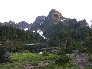
Mount Cruiser is a 6,104-foot-elevation (1,860-meter) mountain summit located in the Olympic Mountains, in Mason County of Washington state, United States. It is situated in Mount Skokomish Wilderness on land managed by Olympic National Forest. Cruiser is the highest point on Sawtooth Ridge, and its nearest higher peak is Mount Skokomish, 2.1 mi (3.4 km) to the north-northeast. Cruiser has two sub-peaks, Alpha, and Beta, the latter of which lies on the Olympic National Park boundary. The first ascent of the peak was made in 1937 by Paul Crews and Ray Layton. The mountain was named by the first ascent party to recognize their club, the Bremerton Ski Cruisers. The mountain's toponym was officially adopted in 1961 by the United States Board on Geographic Names. Precipitation runoff from the mountain drains into the Hamma Hamma River.

Mount Lena is a 5,995-foot-elevation mountain summit located in the Olympic Mountains, in Jefferson County of Washington state. It is situated within Olympic National Park, immediately north and 1,500 feet above the shore of Upper Lena Lake. Mt. Lena has a subsidiary peak, East Peak (5800+ ft/1768+ m), which lies northeast of the lake. Mount Bretherton lies across the lake to the south, Mount Stone is three miles to the southwest, and The Brothers approximately 3.5 miles to the northeast. Precipitation runoff from the mountain drains north to the Duckabush River, and south into the Hamma Hamma River via Lena Creek. The non-technical ascent of Mount Lena involves hiking eight miles (one-way) and 5,300 feet elevation gain via the Upper Lena Lake Trail and cross-country above the lake, with most favorable conditions from July through September. There are pleasant campsites at the lake, and the ascent to the summit takes 1.5 hour from the lake. This mountain's toponym has been officially adopted by the United States Board on Geographic Names.
Mount Bretherton is a 5,960-foot-elevation (1,817-meter) mountain summit located in the Olympic Mountains, in Jefferson County of Washington state. It is situated within Olympic National Park, immediately south and 1,400 feet above the shore of Upper Lena Lake. Mount Lena lies across the lake to the north, Mount Stone is 2.8 miles to the west-southwest, and The Brothers approximately four miles to the northeast. Precipitation runoff from the mountain drains south to the Hamma Hamma River via Boulder, Delta, and Lena Creeks. Topographic relief is significant as it rises over 5,100 feet above the river in two miles. The non-technical ascent of Mount Bretherton involves hiking eight miles (one-way) and 5,300 feet elevation gain via the Upper Lena Lake Trail and cross-country above the lake, with most favorable conditions from July through September. There are pleasant campsites at the lake, and the ascent to the summit takes two hours from the lake. This mountain's name has been officially adopted by the United States Board on Geographic Names.
Unicorn Peak is a 5,100-foot-elevation (1,554-meter) mountain summit located within Olympic National Park in Clallam County of Washington state. Unicorn Peak is situated seven miles southwest of Port Angeles and three miles north-northwest of the park's Hurricane Ridge visitor center, in Daniel J. Evans Wilderness. Precipitation runoff from the mountain drains west to the Elwha River via Little River and Griff Creek. Topographic relief is significant as the west aspect rises 4,800 feet above the Elwha valley in approximately three miles.

Mount Seattle is a 6,246-foot (1,904-metre) mountain summit deep within Olympic National Park in Jefferson County of Washington state. Part of the Olympic Mountains, Mount Seattle is situated 7.5 miles southeast of Mount Olympus, and set within the Quinault Rainforest and Daniel J. Evans Wilderness. The nearest higher neighbor is Mount Meany, 1.65 miles (2.66 km) to the north-northwest, and Mount Noyes rises one mile to the northwest. Precipitation runoff from the mountain drains north into headwaters of the Elwha River, and south into tributaries of the Quinault River. Topographic relief is significant as the northeast aspect of the peak rises over 3,800 feet (1,200 m) above the Elwha valley in approximately 1.5-mile. Low Divide forms the saddle between Mt. Seattle and Mount Christie.

Mount Wilder is a 5,939-foot (1,810-metre) mountain summit located near the head of the Elwha Valley, deep within Olympic National Park in Jefferson County of Washington state. Part of the Olympic Mountains, Wilder represents the southernmost peak of the Bailey Range. It is situated 8.7 miles east-southeast of Mount Olympus, and is set within the Daniel J. Evans Wilderness. Neighbors include line parent Mount Dana, 2.3 miles (3.7 km) to the northeast, and Mount Seattle rises 3.7 miles to the southwest. The headwaters of the Goldie River form on the south slope of the mountain, and precipitation runoff from the mountain drains into Goldie River and other tributaries of the Elwha River. Topographic relief is significant as the south aspect of the peak rises nearly 3,800 feet (1,160 m) in less than two miles.

Mount Steel is a 6,225-foot-elevation (1,897-meter) mountain summit located in the Olympic Mountains, in Jefferson County of Washington state. It is situated in Olympic National Park and the Daniel J. Evans Wilderness. The nearest higher neighbor is Mount Duckabush, 1.36 mi (2.19 km) to the southwest. Precipitation runoff from the mountain drains south into tributaries of the North Fork Skokomish River, and north into headwaters of the Duckabush River. Topographic relief is significant as the summit rises over 3,400 feet (1,036 m) above the Duckabush River in approximately one mile.

Ludden Peak is a 5,854-foot (1,784-metre) mountain summit located within Olympic National Park in Jefferson County of Washington state. Ludden Peak is part of the Bailey Range, which is a subrange of the Olympic Mountains, and is set within the Daniel J. Evans Wilderness. In clear weather, the mountain can be seen from the park's visitor center on Hurricane Ridge. The nearest higher neighbor is Mount Scott, one mile to the south-southeast, line parent Mount Ferry rises 1.6 mi (2.6 km) to the southwest, Dodger Point is 1.9 mi (3.1 km) to the northeast, and Stephen Peak is set 2.7 mi (4.3 km) to the northwest. Precipitation runoff from the mountain drains into tributaries of the Elwha River.

O'Neil Peak is a 5,758-foot-elevation (1,755-meter) mountain summit located in the Olympic Mountains, in Jefferson County of Washington state. It is situated in Olympic National Park and the Daniel J. Evans Wilderness. The nearest higher neighbor is Mount Duckabush, 1.6 mi (2.6 km) to the east-northeast, and O'Neil Pass lies 1.5-mile to the northeast. Precipitation runoff from the mountain drains into tributaries of the Quinault River. Topographic relief is significant as the summit rises over 4,300 feet (1,310 m) above the Quinault River in approximately 1.5-mile, and 2,700 feet above O'Neil Creek in one-half-mile.

Mount Barnes is a 5,987-foot (1,825-metre) mountain summit in Olympic National Park in Jefferson County of Washington state. Mount Barnes is part of the Bailey Range, which is a subrange of the Olympic Mountains, and is set within the Daniel J. Evans Wilderness. Neighbors include Mount Queets, 1.7 mi (2.7 km) to the southwest, and Mount Olympus is set 6.2 mi (10.0 km) to the west. Precipitation runoff from the mountain drains west into the Queets River, south into headwaters of the Elwha River, and northeast into Goldie River which is a tributary of the Elwha. Topographic relief is significant as the summit rises 3,200 feet (975 m) above Elwha Basin in approximately two miles.
Mount Rose is a 4,301-foot-elevation (1,311 meter) mountain summit located in the southeast portion of the Olympic Mountains, in Mason County of Washington state. It is situated in the Mount Skokomish Wilderness, on land managed by Olympic National Forest. The nearest higher neighbor is line parent Copper Mountain, 1.2 mi (1.9 km) to the north, and Mount Ellinor is 1.7 mi (2.7 km) to the northeast. Precipitation runoff from the mountain drains into Lake Cushman, and topographic relief is significant as the summit rises approximately 3,600 feet (1,100 m) above the lake in less than one mile. Old-growth forests of Douglas fir, western hemlock, and western redcedar grow on the slopes surrounding the peak. In 2006, the Bear Gulch Fire scorched 750 acres of forest on the slopes of Mount Rose from lake level to the summit. Access to the summit is via the 3.2-mile-long Mt. Rose Trail which gains 3,500 feet of elevation.
Copper Mountain is a 5,425-foot (1,654 m) mountain summit located in the southeast portion of the Olympic Mountains, in Mason County of Washington state. It is situated on the boundary shared by Daniel J. Evans Wilderness and Mount Skokomish Wilderness, as well as the shared common border of Olympic National Park with Olympic National Forest. The nearest higher neighbor is Mount Ellinor, 1.67 miles (2.69 km) to the east. Wagonwheel Lake lies immediately north of the peak. Topographic relief is significant as the summit rises nearly 4,700 feet (1,433 m) above the Staircase Ranger Station at Lake Cushman in approximately 1.5 miles (2.4 km). Precipitation runoff from the mountain drains north into the Hamma Hamma River, and south into the North Fork Skokomish River, thence Lake Cushman.
Jefferson Peak is a 5,720-foot (1,743 m) mountain summit located in the Olympic Mountains in Mason County of Washington state. It is situated in the Mount Skokomish Wilderness, on land managed by Olympic National Forest. The mountain's toponym honors Thomas Jefferson (1743–1826), the third president of the United States. The nearest higher neighbor is line parent Mount Pershing, 1.3 mi (2.1 km) to the southwest. Precipitation runoff drains into Jefferson Creek and the Hamma Hamma River. Topographic relief is significant as the north aspect rises over 4,100 feet (1,200 m) above the Hamma Hamma valley in approximately one mile.


