Mount Elgon is an extinct shield volcano on the border of Uganda and Kenya, north of Kisumu and west of Kitale. The mountain's highest point, named "Wagagai", is located entirely within Uganda. Although there is no verifiable evidence of its earliest volcanic activity, geologists estimate that Mount Elgon is at least 24 million years old, making it the oldest extinct volcano in East Africa. The mountain's name originates from its Maasai name, “Ol Doinyo Ilgoon”.

The Blue Range is a mountain range of the Canadian Rockies, located on the Continental Divide in Banff National Park, Canada. The range was so named on account of its blueish colour when viewed from afar. Mount Alcantara is the highest point in the range.
Mount Afadja, known as Afadjato to the Ewe people of Ghana and Togo, is one of the highest mountains in Ghana. The summit is located in the Volta Region, near the border with Togo, close to the villages of Liati Wote and Gbledi Gbogame in the Afadjato South District and Hohoe Municipality, respectively. It is about 178 kilometers (111 mi) northeast of Accra, and 178 kilometers (111 mi) northwest of Lomé. Part of the Agumatsa sub-range of the West Africa Mountains, its summit is often cited at 885 metres (2,904 ft) above sea level, but in reality is only 587 metres (1,926 ft). The summit of Mount Aduadu lies 3.5 kilometers (2 mi) to the east, while Ghana's highest peak, Leklata, lies about 4.6 kilometers to the east.

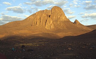
Mount Tahat is the highest mountain in Algeria. It sits at an elevation of 2,908 metres. Other sources indicate an elevation of 3,003 metres (9,852 ft). Tahat is also the highest peak in the Hoggar Mountains. Its nearest city is Tamanrasset which is located 56 kilometres (35 mi) to the south.

Mount Oxford is a high mountain summit of the Collegiate Peaks in the Sawatch Range of the Rocky Mountains of North America. The 14,156.3-foot (4,315 m) fourteener is located in the Collegiate Peaks Wilderness of San Isabel National Forest, 14.2 miles (22.9 km) northwest of the Town of Buena Vista in Chaffee County, Colorado, United States. The mountain was named in honor of the University of Oxford.

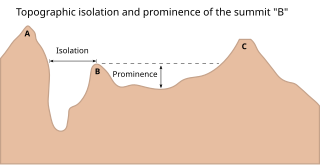
The topographic isolation of a summit is the minimum distance to a point of equal elevation, representing a radius of dominance in which the peak is the highest point. It can be calculated for small hills and islands as well as for major mountain peaks and can even be calculated for submarine summits. Mount Everest, the highest point on Earth, has an undefined isolation, since there are no higher points to reference.
Mount Loch is a mountain in the Victorian Alps of the Great Dividing Range, located in the Australian state of Victoria. The summit of Mount Loch is at 1,887 metres (6,191 ft) AHD and it is the fourth highest mountain in the state.

Mount Fitch is the third-highest peak in the Commonwealth of Massachusetts at 3,104 feet (946 m). It is located on the ridge between Mount Greylock at 3,489 feet (1,063 m) to its south and Mount Williams at 2,951 feet (899 m) to its north. The peak sits in the northwest corner of the Town of Adams in Berkshire County. The forested summit is approximately 123 yards (112 m) due west of a local high-point on the Appalachian Trail. Mount Fitch does not meet the Appalachian Mountain Club's prominence criterion of 200 vertical feet of separation from adjacent peaks as outlined in New England's Four-thousand footers list. Currently there is no side-spur trail or signage directing a hiker to the summit of Mt. Fitch from the Appalachian Trail; however, there is a wooden placard at the summit itself. The top is infrequently visited by hikers due to its anonymity, the bushwhack necessary to reach the top and the viewless summit.

Ypsilon Mountain, elevation 13,520 ft (4,121 m), is in the Mummy Range of Rocky Mountain National Park in northern Colorado. The mountain, along with Mount Chiquita, is most easily accessed from a trailhead on Fall River Road to the south.
Mount Fainter South is a mountain in the Victorian Alps of the Great Dividing Range, located in the Australian state of Victoria. The summit is at 1,883 metres (6,178 ft) AHD and is located in the Alpine National Park.
Mount Smith is a mountain located in the South West Ethiopia Peoples' Region, Ethiopia. Mount Smith is an ultra-prominent peak in the Central Ethiopian Highlands and is the 46th highest in Africa. It has an elevation in 2,560 m.
Mount Maigudo is a mountain located in Oromiya, Ethiopia. Maigudo is an Ultra-prominent peak and is the 62nd highest in Africa. It has an elevation of 3,359 m.


