
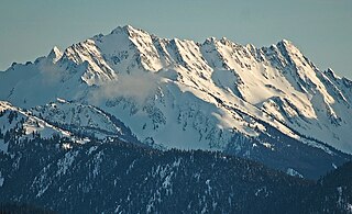
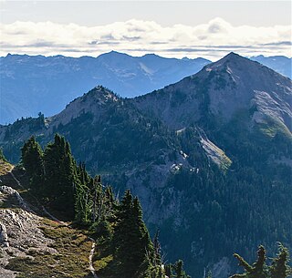
Mount Angeles is located just south of Port Angeles, Washington in the Olympic National Park. It is the highest peak in the Hurricane Ridge area. The summit, which offers panoramic views of the Strait of Juan de Fuca and many of the peaks of the interior Olympic Mountains can be climbed from the Klahane Ridge trail.

Mount Meany is a prominent 6,695-foot (2,041-metre) mountain summit located deep within Olympic National Park in Jefferson County of Washington state. With a good eye and clear weather, the top of the mountain can be seen from the visitor center at Hurricane Ridge. The nearest neighbor is Mount Noyes less than one mile to the south, and the nearest higher peak is Circe (6,847 ft) on Mount Olympus, 4.07 mi (6.55 km) to the northwest. There are scrambling routes on the east side, via Noyes-Meany col, and via the ridge from Mount Queets. Due to heavy winter snowfalls, Mount Meany supports several small glaciers on its north and east slopes, despite its modest elevation. Precipitation runoff from the mountain drains into the headwaters of both the Elwha and Queets Rivers.

Mount Queets is a 6,476-foot (1,974-metre) mountain summit located deep within Olympic National Park in Jefferson County of Washington state, United States. With a good eye and clear weather, the top of the mountain can be seen from the visitor center at Hurricane Ridge. The nearest higher peak is Mount Meany (6,695 ft), 0.8 mi (1.3 km) to the south. Due to heavy winter snowfalls, Mount Queets supports the Queets Glacier in a cirque on its north slope, despite its modest elevation. Precipitation runoff from the mountain drains into the headwaters of both the Elwha River and Queets River. There are scrambling routes ranging from class YDS 2 via the North Ridge, class 3 via the ridge from Mt. Meany, and class 4 via the Queets Glacier.
West Peak is a 7,365-foot-elevation (2,245 m) summit in the Olympic Mountains, in Jefferson County of Washington state. Rising in the center of Olympic National Park, it is the highest peak on the Anderson Massif. West Peak is the hydrographic apex of the Olympic Mountains, with precipitation runoff flowing outward to the Pacific Ocean via Quinault River, the Strait of Juan de Fuca via Elwha River, and Hood Canal via the Dosewallips River. The Eel Glacier is situated in a cirque east of the summit, and an unnamed glacier resides in the south cirque. The nearest higher peak is Mount Mystery, 7.73 miles (12.44 km) to the northeast. The first ascent of the peak was made in 1930 by E. B. Hamilton. Legend has it that the mountain's name is for Mr. West, a participant in the 1890 O'Neil Expedition, rather than for its apparent position on the Anderson Massif. The West Branch of the Quinault River was named after him in 1890.
Sentinel Peak is a 6,592-foot-high (2,009 m) mountain summit located in the Olympic Mountains, in Jefferson County of Washington state. Rising in the center of Olympic National Park, its nearest higher neighbor is Mount Fromme, 1.42 miles (2.29 km) to the northwest. Sentinels Sister is a lower 6,301-foot-high (1,921 m) companion summit situated 0.65 miles (1.05 km) to the southwest. The two peaks stand as sentinels above the Dosewalips Valley and Hayden Pass, and were possibly named by an early expedition of the Seattle Mountaineers. Precipitation runoff from the peak drains to Hood Canal via the Dosewallips River.

Mount Ferry is a 6,195-foot (1,888-metre) mountain summit located within Olympic National Park in Jefferson County of Washington state. Mount Ferry is the eighth-highest peak in the Bailey Range, which is a subrange of the Olympic Mountains. In clear weather, the mountain can be seen from the visitor center at Hurricane Ridge. Its nearest higher neighbor is Mount Pulitzer, 0.6 mi (0.97 km) to the southwest. Stephen Peak is set 2.26 mi (3.64 km) to the northwest, and Mount Olympus is 7.2 mi (11.6 km) to the southwest. Precipitation runoff from the mountain drains into tributaries of the Elwha and Hoh Rivers.
Mount Pulitzer, also known as Snagtooth, is a 6,283-foot (1,915-metre) mountain summit located within Olympic National Park in Jefferson County of Washington state. Mount Pulitzer is the sixth-highest peak in the Bailey Range, which is a subrange of the Olympic Mountains. Its nearest neighbor is Mount Ferry, 0.58 mi (0.93 km) to the northeast, and its nearest higher neighbor is Stephen Peak, 2.58 mi (4.15 km) to the north. Mount Olympus is set 6.8 mi (10.9 km) to the southwest. In clear weather, the mountain can be seen from the visitor center at Hurricane Ridge. Precipitation runoff from the mountain drains into tributaries of the Elwha and Hoh Rivers. The first ascent of the summit was made in 1961 by Doug Waali, Bob Wood, and Kent Heathershaw via the east ridge.

Mount Claywood is a 6,836-foot (2,084-metre) mountain summit located within Olympic National Park in Jefferson County of Washington state. It is situated at the head of Lost River, and 15 mi (24 km) east of Mount Olympus. Its nearest higher neighbor is Mount Cameron, 2.4 mi (3.9 km) to the northeast. Other nearby peaks include Mt. Fromme, 0.58 mi (0.93 km) to the southeast, and Sentinel Peak, 2 mi (3.2 km) also to the southeast. Precipitation runoff from the mountain drains north and west into tributaries of the Elwha River, and east into Claywood Lake, thence Dosewallips River.

Chimney Peak is a 6,917-foot-elevation (2,108-meter) mountain summit located within Olympic National Park in Jefferson County of Washington state. Chimney Peak is situated near the head of Elwha Valley, and immediately north above Enchanted Valley. Topographic relief is significant as the southeast aspect rises 4,800 feet above Enchanted Valley in less than one mile. Enchanted Valley is also known as Valley of 10,000 Waterfalls, and numerous waterfalls tumble down the immense cliffs of Chimney Peak. Neighbors include Crystal Peak, 2.2 mi (3.5 km) to the north, White Mountain 3.5 mi (5.6 km) to the east, and West Peak 3.4 mi (5.5 km) to the northeast. Precipitation runoff from the mountain drains north to the Elwha River, and south to the Quinault River.

Crystal Peak is a 6,896-foot-elevation (2,102-meter) mountain summit located within Olympic National Park in Jefferson County of Washington state. Crystal Peak is situated two miles north of Enchanted Valley, near the heads of Hayes River and Quinault River. Topographic relief is significant as the northeast aspect rises 3,300 feet above Hayes River in less than one mile. Precipitation runoff from the mountain drains north to the Elwha River via Hayes River and Godkin Creek. Neighbors include line parent Chimney Peak, 2.2 mi (3.5 km) to the south, and proximate parent West Peak, 2.0 mi (3.2 km) to the east. The lower slopes of the mountain are surrounded by Western Red Cedar, Sitka Spruce, Western Hemlock, Alaskan Cedar, Mountain Hemlock, and Douglas-fir of the Quinault Rainforest.
Unicorn Peak is a 5,100-foot-elevation (1,554-meter) mountain summit located within Olympic National Park in Clallam County of Washington state. Unicorn Peak is situated seven miles southwest of Port Angeles and three miles north-northwest of the park's Hurricane Ridge visitor center, in Daniel J. Evans Wilderness. Precipitation runoff from the mountain drains west to the Elwha River via Little River and Griff Creek. Topographic relief is significant as the west aspect rises 4,800 feet above the Elwha valley in approximately three miles.

Mount Seattle is a 6,246-foot (1,904-metre) mountain summit deep within Olympic National Park in Jefferson County of Washington state. Part of the Olympic Mountains, Mount Seattle is situated 7.5 miles southeast of Mount Olympus, and set within the Quinault Rainforest and Daniel J. Evans Wilderness. The nearest higher neighbor is Mount Meany, 1.65 miles (2.66 km) to the north-northwest, and Mount Noyes rises one mile to the northwest. Precipitation runoff from the mountain drains north into headwaters of the Elwha River, and south into tributaries of the Quinault River. Topographic relief is significant as the northeast aspect of the peak rises over 3,800 feet (1,200 m) above the Elwha valley in approximately 1.5-mile. Low Divide forms the saddle between Mt. Seattle and Mount Christie.

Mount Delabarre is a remote 6,024-foot (1,836-metre) mountain summit deep within Olympic National Park in Jefferson County of Washington state. Part of the Olympic Mountains, Mount Delabarre is 12.4 miles southeast of Mount Olympus, set within the Daniel J. Evans Wilderness. The nearest higher neighbor is line parent Mount Christie, 2.5 miles to the west-northwest. Precipitation runoff from the mountain drains north into headwaters of Delabarre Creek, which is a tributary of the Elwha River, and south into Rustler Creek, which is a tributary of the North Fork Quinault River. Topographic relief is significant as the southwest aspect of the peak rises 3,400 feet (1,036 m) above Rustler Creek in approximately one mile.
The Bailey Range is a mountain range located within Olympic National Park in Washington state.

Ludden Peak is a 5,854-foot (1,784-metre) mountain summit located within Olympic National Park in Jefferson County of Washington state. Ludden Peak is part of the Bailey Range, which is a subrange of the Olympic Mountains, and is set within the Daniel J. Evans Wilderness. In clear weather, the mountain can be seen from the park's visitor center on Hurricane Ridge. The nearest higher neighbor is Mount Scott, one mile to the south-southeast, line parent Mount Ferry rises 1.6 mi (2.6 km) to the southwest, Dodger Point is 1.9 mi (3.1 km) to the northeast, and Stephen Peak is set 2.7 mi (4.3 km) to the northwest. Precipitation runoff from the mountain drains into tributaries of the Elwha River.

Cat Peak is a 5,940-foot (1,811-metre) mountain summit within Olympic National Park in Clallam County of Washington state.
Mount Scott is a 5,913-foot (1,802-metre) mountain summit located within Olympic National Park in Jefferson County of Washington state.

Mount Barnes is a 5,987-foot (1,825-metre) mountain summit in Olympic National Park in Jefferson County of Washington state. Mount Barnes is part of the Bailey Range, which is a subrange of the Olympic Mountains, and is set within the Daniel J. Evans Wilderness. Neighbors include Mount Queets, 1.7 mi (2.7 km) to the southwest, and Mount Olympus is set 6.2 mi (10.0 km) to the west. Precipitation runoff from the mountain drains west into the Queets River, south into headwaters of the Elwha River, and northeast into Goldie River which is a tributary of the Elwha. Topographic relief is significant as the summit rises 3,200 feet (975 m) above Elwha Basin in approximately two miles.

Mount Childs is a 6,193-foot (1,888-metre) mountain summit in Olympic National Park in Jefferson County of Washington state. Mount Childs is part of the Bailey Range, which is a subrange of the Olympic Mountains, and is set within the Daniel J. Evans Wilderness. Neighbors include line parent Mount Pulitzer, 1.7 mi (2.7 km) to the north, Mount Barnes, 2 mi (3.2 km) to the south, and Mount Olympus is situated 5.6 mi (9.0 km) to the west. Precipitation runoff from the mountain drains west into headwaters of the Hoh River, and east into Goldie River, which is a tributary of the Elwha River. The first ascent of the summit was made August 6, 1961, by Doug Waali, Bob Wood, and Kent Heathershaw via the east slope.
Mount Norton is a 6,397-foot-elevation (1,950-meter) mountain summit located in the Olympic Mountains in Jefferson County of Washington state. It is situated within Olympic National Park, and is set within the Daniel J. Evans Wilderness. Precipitation runoff from the mountain drains north via the Elwha River and Hayes River. Topographic relief is significant as the east aspect rises 3,200 feet above Hayes River in less than one mile, and the west aspect rises 4,400 feet above the Elwha valley in two miles. The lower slopes of the mountain are surrounded by forests of Western Red Cedar, Sitka Spruce, Western Hemlock, Alaskan Cedar, Mountain Hemlock, and Douglas-fir.


