Mount Zion, Georgia

Last updated
Mount Zion, Georgia
Mount Zion, Georgia City Hall.JPG
Mount Zion City Hall
Flag of Mount Zion, Georgia.svg
Carroll County Georgia Incorporated and Unincorporated areas Mount Zion Highlighted.svg
Location in Carroll County and the state of Georgia
Coordinates: 33°37′52″N85°10′48″W / 33.63111°N 85.18000°W / 33.63111; -85.18000 Coordinates: 33°37′52″N85°10′48″W / 33.63111°N 85.18000°W / 33.63111; -85.18000
Country United States
State Georgia
County Carroll
Area
[1]
  Total9.81 sq mi (25.41 km2)
  Land9.71 sq mi (25.14 km2)
  Water0.10 sq mi (0.27 km2)
Elevation
1,201 ft (366 m)
Population
 (2020)
  Total1,766
  Density181.93/sq mi (70.25/km2)
Time zone UTC-5 (Eastern (EST))
  Summer (DST) UTC-4 (EDT)
ZIP code
30150
Area code 770
FIPS code 13-53620 [2]
GNIS feature ID0332438 [3]
Website www.cityofmountzion.com

Mount Zion is a city in Carroll County, Georgia, United States. The population was 1,696 at the 2010 census. [4]

Contents

History

The City of Mount Zion was established in 1852 by Reverend Thomas Hicks Martin (March 10, 1822 - June 14, 1914), after his family had settled on land that had once been owned by the Creek Confederacy. It became known as Turkey Creek Mills, [5] the name derived from a large wild turkey population found in the area. The city's name was later adopted from the local Mount Zion Methodist Episcopal Church, [6] established 1865, which had soon became the center point of the community, and in 1878 the name Turkey Creek Mills was changed to Mount Zion.

In 1877, Reverend James Mitchell took his ministry to Mount Zion and founded the Mount Zion Seminary, the predecessor institution of the current Mount Zion High School. [7]

The Georgia General Assembly incorporated Mount Zion as a town in 1912 [8] and re-chartered in 1953 and again in 1978.
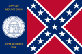
Mount Zion is one of the few cities in Georgia with the Confederate Flag incorporated in its city flag, [9] which is based on the 1956 Georgia state flag and inspired by the Trenton, Georgia city flag that began flying in 2002. The Mount Zion city flag began flying April 10, 2007.

Geography

Mount Zion is located in northern Carroll County at 33°37′52″N85°10′48″W / 33.63111°N 85.18000°W / 33.63111; -85.18000 (33.631113, -85.179868). [10] It is 8 miles (13 km) northwest of Carrollton, the county seat, and 5 miles (8 km) southwest of Interstate 20 in Bremen. John Tanner Park is just south of the city limits off of Highway 16.

According to the United States Census Bureau, Mount Zion has a total area of 9.8 square miles (25.5 km2), of which 9.7 square miles (25.1 km2) is land and 0.15 square miles (0.4 km2), or 1.71%, is water. [4]

Demographics

Historical population
CensusPop.
1920 131
1930 121−7.6%
1940 84−30.6%
1950 14167.9%
1960 21149.6%
1970 26425.1%
1980 44568.6%
1990 51114.8%
2000 1,275149.5%
2010 1,69633.0%
2020 1,7664.1%
U.S. Decennial Census [11]

As of the census [2] of 2000, there were 1,275 people, 434 households, and 351 families residing in the city. The population density was 130.7 inhabitants per square mile (50.5/km2). There were 467 housing units at an average density of 47.9 per square mile (18.5/km2). The racial makeup of the city was 94.12% White, 3.76% African American, 0.24% Native American, 0.94% Asian, 0.24% from other races, and 0.71% from two or more races. Hispanic or Latino of any race were 0.31% of the population.

There were 434 households, out of which 44.5% had children under the age of 18 living with them, 63.6% were married couples living together, 13.1% had a female householder with no husband present, and 18.9% were non-families. 15.7% of all households were made up of individuals, and 6.5% had someone living alone who was 65 years of age or older. The average household size was 2.94 and the average family size was 3.27.

In the city, the population was spread out, with 31.3% under the age of 18, 8.2% from 18 to 24, 34.4% from 25 to 44, 19.3% from 45 to 64, and 6.8% who were 65 years of age or older. The median age was 31 years. For every 100 females, there were 107.0 males. For every 100 females age 18 and over, there were 96.9 males.

The median income for a household in the city was $41,912, and the median income for a family was $43,438. Males had a median income of $31,959 versus $20,662 for females. The per capita income for the city was $16,080. About 11.8% of families and 12.9% of the population were below the poverty line, including 15.8% of those under age 18 and 22.6% of those age 65 or over.

Notable people

Related Research Articles

<span class="mw-page-title-main">Heard County, Georgia</span> County in Georgia, United States

Heard County is a county located in the west central portion of the U.S. state of Georgia. At the 2020 census, the population was 11,412, down from 11,834 in 2010. The county seat is Franklin. The county was created on December 22, 1830.

<span class="mw-page-title-main">Carroll County, Georgia</span> County in Georgia, United States

Carroll County is a county located in the northwestern part of the State of Georgia. As of the 2020 census, its population was 119,148. Its county seat is the city of Carrollton. Carroll County is included in the Atlanta-Sandy Springs-Roswell, GA Metropolitan Statistical Area and is also adjacent to Alabama on its western border.

<span class="mw-page-title-main">West Fork, Arkansas</span> City in Arkansas, United States

West Fork is a city in Washington County, Arkansas, United States. The population is 2,317 at the 2010 census. It is part of the Northwest Arkansas region.

<span class="mw-page-title-main">Roopville, Georgia</span> Town in Georgia, United States

Roopville is a town in Carroll County, Georgia, United States. The population was 218 at the 2010 census.

<span class="mw-page-title-main">Temple, Georgia</span> City in Georgia, United States

Temple is a city in Carroll and Haralson counties in the U.S. state of Georgia. The population was 4,228 at the 2010 census, up from 2,383 in 2000, a 77% increase.

<span class="mw-page-title-main">Morrow, Georgia</span> City in Georgia, United States

Morrow is a city in Clayton County, Georgia, United States. It is part of the Atlanta metropolitan area. Its population was 6,445 at the 2010 census, up from 4,882 in 2000. It is the home of Clayton State University.

<span class="mw-page-title-main">Trenton, Georgia</span> City in Georgia, United States

Trenton is a city and the only incorporated municipality in Dade County, Georgia, United States—and as such, it serves as the county seat. The population was 2,195 at the 2020 census. Trenton is part of the Chattanooga, Tennessee–GA Metropolitan Statistical Area.

<span class="mw-page-title-main">Brinson, Georgia</span> Town in Georgia, United States

Brinson is a town in Decatur County, Georgia, United States. As of the 2020 census, the city had a population of 217.

<span class="mw-page-title-main">Carnesville, Georgia</span> City in Georgia, United States

Carnesville is a city in Franklin County, Georgia, United States, and the county seat. The population was 741 at the 2020 census.

<span class="mw-page-title-main">Buchanan, Georgia</span> City in Georgia, United States

Buchanan is a city and the county seat of Haralson County, Georgia, United States. The population was 1,104 at the 2010 census, up from 941 at the 2000 census.

<span class="mw-page-title-main">West Peoria, Illinois</span> City in Illinois, United States

West Peoria is a city in Peoria County, Illinois, United States. The population was 4,458 at the 2010 census. West Peoria is a suburb of Peoria and is part of the Peoria, Illinois Metropolitan Statistical Area.

<span class="mw-page-title-main">Halbur, Iowa</span> City in Iowa, United States

Halbur is a city in Carroll County, Iowa, United States. The population was 243 at the time of the 2020 census.

<span class="mw-page-title-main">Worthville, Kentucky</span> City in Kentucky, United States

Worthville is a home rule-class city in Carroll County, Kentucky, United States. The population was 185 at the 2010 census.

<span class="mw-page-title-main">South Gate, Maryland</span> Former census-designated place in Maryland, United States

South Gate was a census-designated place (CDP) in Anne Arundel County, Maryland, United States, for the 2000 census, at which time its population was 28,672. It was added primarily to the Glen Burnie CDP for the 2010 census.

<span class="mw-page-title-main">Clitherall, Minnesota</span> City in Minnesota, United States

Clitherall is a city in Otter Tail County, Minnesota, United States. The population was 62 at the 2020 census.

<span class="mw-page-title-main">Hallsville, Missouri</span> City in Missouri, United States

Hallsville is a city in Boone County, Missouri. It is part of the Columbia metropolitan area. The population was 1,614 at the time of the 2020 census. Southeast of the town is Mount Zion Church and Cemetery, the site of the Battle of Mount Zion Church during the Civil War.

<span class="mw-page-title-main">Albany, New Hampshire</span> Town in New Hampshire, United States

Albany is a town in Carroll County, New Hampshire, United States. The population was 759 at the 2020 census.

<span class="mw-page-title-main">Shade Gap, Pennsylvania</span> Borough in Pennsylvania, United States

Shade Gap is a borough in Huntingdon County, Pennsylvania, United States. The population was 105 at the 2010 census.

Maple Glen is a census-designated place (CDP) in Montgomery County, Pennsylvania, United States. The population was 6,742 at the 2010 census.

Lake Carroll is a census-designated place (CDP) in Carroll County, Illinois, United States, surrounding a lake of the same name. It is in northeastern Carroll County and is bordered to the north by Stephenson County. It is 10 miles (16 km) northeast of Mount Carroll, the county seat, and 20 miles (32 km) southwest of Freeport.

References

  1. "2020 U.S. Gazetteer Files". United States Census Bureau. Retrieved December 18, 2021.
  2. 1 2 "U.S. Census website". United States Census Bureau . Retrieved 2008-01-31.
  3. "US Board on Geographic Names". United States Geological Survey. 2007-10-25. Retrieved 2008-01-31.
  4. 1 2 "Geographic Identifiers: 2010 Demographic Profile Data (G001): Mount Zion city, Georgia". U.S. Census Bureau, American Factfinder. Archived from the original on February 12, 2020. Retrieved July 18, 2014.
  5. "The City of Mt. Zion, Georgia official website".
  6. Krakow, Kenneth K. (1975). Georgia Place-Names: Their History and Origins (PDF). Macon, GA: Winship Press. p. 153. ISBN   0-915430-00-2.
  7. "Carroll County Schools official website".
  8. Acts and Resolutions of the General Assembly of the State of Georgia. State printer. 1912. p. 1153.
  9. "Flags of the World - Mt. Zion, Georgia (U.S.)".
  10. "US Gazetteer files: 2010, 2000, and 1990". United States Census Bureau. 2011-02-12. Retrieved 2011-04-23.
  11. "Census of Population and Housing". Census.gov. Retrieved June 4, 2015.