
Owsley County is a county located in the Eastern Coalfield region of the U.S. state of Kentucky. As of the 2020 census, the population was 4,051, making it the second-least populous county in Kentucky. The county seat is Booneville. The county was organized on January 23, 1843, from Clay, Estill, and Breathitt counties and named for William Owsley (1782–1862), the judge of the Kentucky Court of Appeals and Governor of Kentucky (1844–48). According to the 2010 census reports, Owsley County has the second-highest level of child poverty of any county in the United States. In terms of income per household, the county is the poorest in the nation. Between 1980 and 2014, the rate of death from cancer in the county increased by 45.6 percent, the largest such increase of any county in the United States.

Johnson County is a county located in the U.S. state of Kentucky. As of the 2020 census, the population was 22,680. Its county seat is Paintsville. The county was formed in 1843 and named for Richard Mentor Johnson, a colonel of the War of 1812, United States Representative, Senator, and Vice President of the United States.
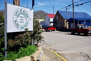
Allen, also known as Allen City, is a home rule-class city in Floyd County, Kentucky, in the United States. The population was 193 at the 2010 census, up from 150 at the 2000 census.
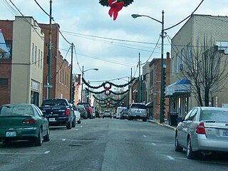
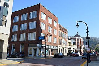
Paintsville is a home rule-class city along Paint Creek in Johnson County, Kentucky, in the United States. It is the seat of its county. The population was 6,459 during the 2010 U.S. Census.
Pippa Passes is a home rule-class city located along Caney Fork in Knott County, eastern Kentucky, United States. Its formal name was chosen to honor benefactors of Alice Lloyd College. Residents commonly call the community "Caney" or "Caney Creek". The population was 533 at the 2010 census, up from 297 at the 2000 census. The small city is located in the mountainous Appalachia region, an area of coal mining.

Louisa is a home-rule class city located in eastern Kentucky at the merger of the Levisa and Tug Forks into the Big Sandy River, which forms part of the state's border with West Virginia. It is the seat of Lawrence County. The population was 2,467 at the 2010 census and an estimated 2,375 in 2018.
Elkhorn City is a home rule-class city in Pike County, Kentucky, in the United States. The population was 982 at the 2010 census. The city is located in proximity to the Breaks Interstate Park.
Pikeville is a home rule-class city in and the county seat of Pike County, Kentucky, United States. The population of Pikeville was 7,754 as of the 2020 U.S. Census. Pikeville serves as a regional economic, educational and entertainment hub for the surrounding areas of eastern Kentucky, Virginia and West Virginia. It is home to the University of Pikeville and the Pikeville Cut-Through, the second-largest earthmoving project in the western hemisphere.

Alum Creek is a census-designated place (CDP) in Kanawha and Lincoln counties along the Coal River in the U.S. state of West Virginia. It includes the unincorporated communities of Alum Creek, Forks of Coal, and Priestley. The CDP had a population of 1,749 at the 2010 census, down from 1,839 at the 2000 census.

The Tug Fork is a tributary of the Big Sandy River, 159 miles (256 km) long, in southwestern West Virginia, southwestern Virginia, and eastern Kentucky in the United States. Via the Big Sandy and Ohio rivers, it is part of the watershed of the Mississippi River.

The Levisa Fork is a tributary of the Big Sandy River, approximately 164 miles (264 km) long, in southwestern Virginia and eastern Kentucky in the United States.
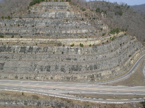
The Pikeville Cut-Through is a rock cut in Pikeville, Kentucky, United States, created by the U.S. Army Corps of Engineers, through which passes a four-lane divided highway, a railroad line, and the Levisa Fork of the Big Sandy River. It is one of the largest civil engineering projects in the western hemisphere. Nearly 18,000,000 cubic yards (14,000,000 m3) of soil and rock were moved, making the Pikeville Cut-Through second only to the Panama Canal when ranking the hemisphere's largest earth-moving projects. Dr. William Hambley, who served as mayor of Pikeville for 29 years, Robert H. Holcomb, Chamber of Commerce president, and Henry Stratton, local attorney, spearheaded the project.

Madison Township is one of ten townships in Jefferson County, Indiana, United States. As of the 2010 census, its population was 17,415 and it contained 8,087 housing units.

Deputy is a mid unincorporated community and census-designated place (CDP) in Graham Township, Jefferson County, Indiana, United States. By road it is approximately 18 miles (29 km) northwest of Madison, the county seat. As of the 2010 census it had a population of 86.
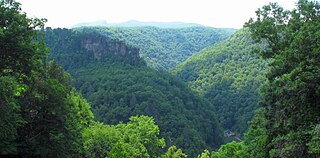
The Russell Fork is a 51.9-mile-long (83.5 km) tributary of the Levisa Fork in southwestern Virginia and southeastern Kentucky in the United States. Known for its whitewater, it rises in the Appalachian Mountains of southwest Virginia, in southern Buchanan County at the base of Big A Mountain, and flows northwest into Dickenson County. The Russell Fork continues to flow through the town of Haysi, Virginia, the Breaks Interstate Park, and the town of Elkhorn City, Kentucky, in Pike County, to the community of Millard, Kentucky where it flows into the Levisa Fork which, together with the Tug Fork, form the Big Sandy River.
Maytown is an unincorporated community and census-designated place in Floyd County, Kentucky, United States.
The Champion Bridge Company, formerly known as Champion Iron Bridge and Manufacturing Company, is a steel fabrication business based in Wilmington, Ohio, in the United States. It has been in business since the 1870s, and several of its works are listed on the National Register of Historic Places.
Garden Village is an unincorporated community in Pike County, Kentucky. It is located on the Levisa Fork of the Big Sandy River, below the Peyton Branch and 4 miles (6.4 km) southeast of Pikeville.
Broad Bottom is an unincorporated community in Pike County, Kentucky, United States.


