Munger Place Historic District

Last updated
Munger Place Historic District
Munger Place Historic District Dallas Wiki (1 of 1).jpg
Munger Place in 2022
Relief map of Texas.png
Red pog.svg
Munger Place Historic District
Usa edcp relief location map.png
Red pog.svg
Munger Place Historic District
Munger Place Historic District (the United States)
Coordinates: 32°47′58″N96°45′51″W / 32.79944°N 96.76417°W / 32.79944; -96.76417 Coordinates: 32°47′58″N96°45′51″W / 32.79944°N 96.76417°W / 32.79944; -96.76417
Country United States
State Texas
Counties Dallas
City Dallas
Area East Dallas
Community Old East Dallas
Area
  Total85 acres (34 ha)
Elevation
492 ft (150 m)
ZIP code
75206, 75214
Area code(s) 214, 469, 972
Website Munger Place Historic District
Munger Place Historic District
ArchitectMultiple
Architectural style Classical Revival, Prairie School, Bungaloid
NRHP reference No. 78002916 [1]
DLMK No. H/11
Significant dates
Added to NRHPSeptember 13, 1978
Designated DLMKJuly 27, 1988 [2]

The Munger Place Historic District is a neighborhood and historic district in Old East Dallas, Texas (USA), generally lying between North Fitzhugh Avenue on the southwest, Gaston Avenue on the northwest, Henderson Avenue on the northeast, and Columbia Avenue on the southeast. Detailed boundaries are defined in the Munger Place Ordinance. It is a Dallas Landmark District and listed on the National Register of Historic Places.

Contents

History

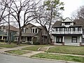
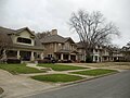
Munger Place was established in 1905 by cotton gin manufacturer Robert S. Munger on 300 acres (1.2 km2) as one of Dallas's first suburbs, and was originally intended to be one of the most exclusive communities in the city. To attract the "right" social element, Munger Place was carefully planned. Just minutes from downtown Dallas by carriage, Munger Place became the very first deed-restricted neighborhood in Texas. Homes had to be a full two stories, cost at least US$2,000 and no house could face a side street. The infrastructure featured such amenities as sidewalks, paved streets, shade trees, sewers, gas mains, and electric street lights. Many of the Dallas' leading businessmen and social elite soon called magnificent Munger Place home.

The Great Depression led many of the community's mansions to be converted into multi-family housing. The neighborhood lost its elite cachet, and by the 1960s many of the nicer houses in the area had been torn down or condemned. Starting in the 1970s, however, Munger Place began to be rediscovered, as enterprising individuals recognized the historic architecture (particularly Prairie Style) and large spaces behind the neighborhood's dilapidated veneer.

Heritage designations

Only a portion of Munger Place is included in the Munger Place Historic District. Munger Place can be described as having northern, western, and southern portions. The northern and western portion of Munger Place is in the Swiss Avenue Historic District. The southern portion generally is in the Munger Place Historic District. Separating the two historic districts is Gaston Avenue, and the lots on either side of Gaston Avenue are excluded from either historic district. [3]

In 1978, the National Park Service added Munger Place Historic District to the National Register of Historic Places. [4] In 1980, the City of Dallas recognized the historic district as a Landmark District. [3] The boundaries of the national and city districts are nearly the same.

Comprising over 250 households it is the largest collection of Prairie-Style homes in America. With most of the homes now completely renovated, Munger Place has once again become a desirable neighborhood for families of all types looking for charming, historic homes near downtown Dallas. Each year the neighborhood holds a home tour and art festival that attracts fans of historic architecture and independent artists.

Education

The neighborhood is served by the Dallas Independent School District (DISD). [5]

Residents in the neighborhood northeast of N Fitzhugh Avenue are zoned to William Lipscomb Elementary School (grades PK-5) in Junius Heights, [6] J.L. Long Middle School, [7] and Woodrow Wilson High School. [8] Residents in the neighborhood southwest of N Fitzhugh Avenue (along a short section of Tremont Street) are zoned to Ignacio Zaragoza Elementary School, [9] Alex W. Spence Middle School, [10] and North Dallas High School. [11]

Residents' children also attend various magnet schools in the district, as well as a variety of private schools in and around the area including Holy Trinity Catholic School, St. Thomas Aquinas Catholic School, Lakehill Preparatory School, St. John's Episcopal School and First Baptist Academy.[ citation needed ]

See also

Related Research Articles

<span class="mw-page-title-main">Addison, Texas</span> Town in Texas, United States

Addison is an incorporated town in Dallas County, Texas, in the United States. Addison is situated to the immediate north of the city of Dallas, with a 2020 census population of 16,661. Addison and Flower Mound were the only two Texas municipalities labeled "towns" with a population greater than 10,000 at the 2010 census; since then the municipalities of Prosper and Trophy Club—also identifying as towns—have also exceeded 10,000 in population estimates.

<span class="mw-page-title-main">Balch Springs, Texas</span> City in Texas, United States

Balch Springs is a city in Dallas County, Texas, United States. It is an inner-ring suburb of Dallas and part of the Dallas–Fort Worth metroplex. Its population was 23,728 at the 2010 census, and 25,007 at 2019's census estimates.

<span class="mw-page-title-main">Highland Park, Texas</span> Town in Texas, United States

Highland Park is a town in central Dallas County, Texas, United States. The population was 8,864 in 2020. It is located between the Dallas North Tollway and U.S. Route 75, 4 miles (6 km) north of downtown Dallas.

<span class="mw-page-title-main">Combine, Texas</span> City in Texas, United States

Combine is a city in Dallas and Kaufman counties in the U.S. state of Texas. The population was 2,245 in 2020.

<span class="mw-page-title-main">Lakewood, Dallas</span>

Lakewood is a neighborhood in East Dallas, Texas (USA). It is adjacent to White Rock Lake and Northeast of Downtown Dallas. Lakewood is bound by Mockingbird Lane to the north, Abrams Road to the west, Gaston Avenue to the south, and White Rock Lake to the east.

<span class="mw-page-title-main">Junius Heights, Dallas</span> Place

Junius Heights is Dallas' largest historic district, a neighborhood of more than 800 homes in East Dallas, Texas (USA) situated east of Munger Place, south of Swiss Avenue and southwest of Lakewood. It is relatively rectangular, bounded roughly by Gaston Avenue on the NW, Paulus Avenue on the NE, Reiger Avenue on the SE, and Henderson Avenue on the SW.

<span class="mw-page-title-main">Vickery Place, Dallas</span>

Vickery Place is a historic neighborhood in East Dallas, Texas, bounded on the north by Goodwin Avenue, on the west by North Central Expressway and Henderson, on the south by Belmont, and on the east by Greenville Avenue. Although Vickery Place is considered by some to be part of the M Streets area, it is strictly speaking not as it is south of the Greenland Hills subdivision. Vickery Place has seen much improvement and property value growth over the past several years due to its close proximity to Downtown Dallas and Uptown, and its location bordering the vibrant Lower Greenville Avenue and Knox-Henderson entertainment and shopping districts.

<span class="mw-page-title-main">North Dallas High School</span> High school in Dallas, Texas, United States

North Dallas High School is a public secondary school located in the Oak Lawn area of Dallas, Texas, United States. It enrolls students in grades 9-12 and is a part of the Dallas Independent School District. As of 2017, the principal administrator is Katherine Eska.

<span class="mw-page-title-main">Swiss Avenue Historic District</span> United States historic place

The Swiss Avenue Historic District is a residential neighborhood in East Dallas, Dallas, Texas (USA). It consists of installations of the Munger Place addition, one of East Dallas' early subdivisions. The Swiss Avenue Historic District is a historic district of the city of Dallas, Texas. The boundaries of the district comprise both sides of Swiss Avenue from Fitzhugh Street, to just north of La Vista, and includes portions of Bryan Parkway. The District includes the 6100-6200 blocks of La Vista Drive, the west side of the 5500 block of Bryan Parkway the 6100-6300 blocks of Bryan Parkway, the east side of the 5200-5300 block of Live Oak Street, and the 4900-6100 blocks of Swiss Avenue. The entire street of Swiss Avenue is not included within the bounds of the Swiss Avenue Historic District. Portions of the street run through Dallas' Peaks Suburban Addition neighborhood and Peak's Suburban Addition Historic District.

Lower Greenville is a neighborhood in east Dallas, Texas (USA), west of Lakewood. Specifically, the neighborhood is the area adjacent to Greenville Avenue south of Mercedes Avenue and north of Belmont Avenue. The area south of Belmont Avenue is often, and more specifically, called "Lowest Greenville," and the area north of Mockingbird Lane is called "Upper Greenville." "Lower Greenville" is also used to refer to the neighborhoods surrounding Greenville Avenue, including Vickery Place, the Belmont Addition, Glencoe, Greenland Hills, and Stonewall Terrace. It straddles Dallas Council Districts 14 and 2.

Greenland Hills is a neighborhood in east Dallas, Texas (USA). It is bounded on the west by North Central Expressway, on the south by Vanderbilt Avenue, on the east by Greenville Avenue and on the north by McCommas Boulevard.

Hollywood/Santa Monica is a neighborhood in east Dallas, Texas, United States. The neighborhood lies to the northwest of SH 78 and the Tennison Park Golf Course. It is a part of a special conservation district to protect the subdivisions of Hollywood Heights and Santa Monica.

Los Altos is a neighborhood in West Dallas, Texas, United States. Its boundaries are Canada Drive to the north, Singleton Boulevard to the south, Sylvan Avenue on the east, and Chihuahua Avenue on the west.

<span class="mw-page-title-main">Uptown, Dallas</span> Place in Texas, United States

Uptown is a PID and a dense neighborhood in Dallas, Texas. Uptown is north of and adjacent to downtown Dallas, and is bordered by US 75 on the east, N Haskell Avenue on the northeast, the Katy Trail on the northwest, Bookhout Street and Cedar Springs Road on the west, N Akard Street on the southwest and Spur 366 on the south.

East Dallas, also referred to by the East Dallas Chamber of Commerce as the Lake & Garden District, is an expansive area of numerous communities and neighborhoods in Dallas, Texas that border nearby suburban cities to the east such as Garland, Mesquite, and Balch Springs, Texas.

<span class="mw-page-title-main">Downtown Dallas</span> Place in Texas, United States

Downtown Dallas is the central business district (CBD) of Dallas, Texas, United States, located in the geographic center of the city. It is the second-largest business district in the state of Texas. The area termed "Downtown" has traditionally been defined as bounded by the downtown freeway loop, bounded on the east by I-345 (although known and signed as the northern terminus of I-45 and the southern terminus of US 75, on the west by I-35E, on the south by I-30, and on the north by Woodall Rodgers Freeway.

Caruth Terrace is a primarily residential neighborhood in eastern Dallas, Texas (USA). It is adjacent to several other East Dallas neighborhoods, including North Stonewall Terrace, University Meadows, Hillside, and Wilshire Heights.

Wilshire Heights is a residential neighborhood in eastern Dallas, Texas (USA). It is adjacent to several East Dallas neighborhoods including: Lakewood, Stonewall Terrace, Lakewood Heights, and Caruth Terrace.

<span class="mw-page-title-main">Lakewood Heights, Dallas</span>

Lakewood Heights is a residential neighborhood in Dallas, Texas (USA), bounded by Abrams Road to the east, Monticello Avenue to the north, Skillman Street to the west, and Richmond Avenue to the south. It located in East Dallas. Lakewood Heights is approximately one-half mile (0.8 km) wide (east-west) and three-quarters of a mile (1.2 km) long (north-south). It covers approximately 240 acres or slightly less than 0.375 square miles (1000m²). It is adjacent to several East Dallas neighborhoods, including Lakewood, Lower Greenville, and Wilshire Heights.

References

  1. "National Register Information System". National Register of Historic Places . National Park Service. November 2, 2013.
  2. Analeslie Muncy (July 27, 1988). "Ordinance No. 20024" (PDF). City of Dallas. Retrieved September 4, 2018.
  3. 1 2 Department of Urban Planning (1980). Designation Report: Munger Place. City of Dallas, Texas.
  4. National Park Service. "Search". npgallery.nps.gov. Retrieved 2018-11-22.
  5. "Munger Place Historic District". Dallas City Hall. Retrieved 2019-11-09.
  6. "2019-20 William Lipscomb Elementary Attendance Zone Grades PK-5" (PDF). Dallas Independent School District . Retrieved 2019-11-09.
  7. "2019-20 J. L. Long Middle Attendance Zone Grades 6-8" (PDF). Dallas Independent School District . Retrieved 2019-11-09.
  8. "2019-20 Woodrow Wilson High Attendance Zone Grades 9-12" (PDF). Dallas Independent School District . Retrieved 2019-11-09.
  9. "2019-20 Ignacio Zaragoza Elementary Attendance Zone Grades PK-5" (PDF). Dallas Independent School District . Retrieved 2019-11-09.
  10. "2019-20 Alex W. Spence Middle Attendance Zone Grades 6-8" (PDF). Dallas Independent School District . Retrieved 2019-11-09.
  11. "2019-20 North Dallas High Attendance Zone Grades 9-12" (PDF). Dallas Independent School District . Retrieved 2019-11-09.

Commons-logo.svg Media related to Munger Place Historic District, Dallas at Wikimedia Commons