Muriqui, Mangaratiba

Last updated
Muriqui
Vila Muriqui
District
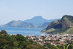
VISTA PANORAMICA DE MURIQUI2.jpg
Panoramic view of Muriqui
Brazil Rio de Janeiro Mangaratiba Muriqui location map.svg
Location in Mangaratiba
Brazil Rio de Janeiro location map.svg
Red pog.svg
Muriqui
Location in Rio de Janeiro
Coordinates: 22°55′33.8″S43°56′52.2″W / 22.926056°S 43.947833°W / -22.926056; -43.947833
Country Flag of Brazil.svg  Brazil
State Bandeira do estado do Rio de Janeiro.svg Rio de Janeiro
Municipality/CityBandeira de Mangaratiba - RJ.svg Mangaratiba
Establishedc.1597
Incorporated (district)1 December 1949
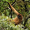
Named for Muriqui spider monkeys
Area
  Total38.0268 km2 (14.6822 sq mi)
  [lower-alpha 1]
Elevation
[2] (Posto de Saúde Muriqui)
5 m (16 ft)
Highest elevation
[2] [3] (Serra de Muriqui)
1,226 m (4,022 ft)
Lowest elevation
[2] (Praia de Muriqui)
0 m (0 ft)
Population
 (2010) [1]
  Total10,241
  Density269.31/km2 (697.5/sq mi)
Demonyms Vila-muriquiense; muriquiense
Sex ratio (2010)
[1]
  Female5,225 (51.02%)
  Male5,016 (48.98%)
Time zone UTC−3 (BRT)
Website www.mangaratiba.rj.gov.br/novoportal/distritos/muriqui.html

Muriqui (also known as Vila Muriqui) is a district [4] of the municipality of Mangaratiba, located within the Greater Rio de Janeiro, Brazil. It is part of the Green Coast. Highway BR-101 passes through the district.

Contents

The district has a patron saint, the Blessed Virgin Mary (Portuguese : Nossa Senhora das Graças). [5] Since the 1950s, the local parish has celebrated annually on the 27th of November, the date Catherine Labouré reportedly had a vision of her in 1830. [6]

Etymology

The district was named after muriquis, a genus of spider monkeys. [7] The name "muriqui" itself comes from a corruption of the word myraqui, of the Tupi language, with the alternates buriqui, barigui and baregui. [8] According to Alcides Pissinatti, in "Management of Muriquis in Captivity" (2005): [9]

Its approximate meaning is "people that swing as they come and go" and it refers particularly to the large, pale brown monkeys that inhabit forests along Brazil's Atlantic coast, initially assigned the scientific name of Ateles hypoxanthus by Wied-Neuwied (1958).

However, according to von Martius' glossary, the word comes from the Tupi words jemoroo ("to nourish"; muru, "nutrient") and aiké (a contraction of aikobê: "to have", "to exist"). [10]

History

Colonial era

Prior to 1567, all land that now belongs to Mangaratiba – including modern-day Muriqui – was part of the freguesia of Angra dos Reis, under the Captaincy of São Vicente. After that date, those lands became part of the (Royal) Captaincy of Rio de Janeiro. [11] In 1568, the colonization of the region of modern-day Mangaratiba begins through the distribution of land to the Sá family. [12]

At some point before 1598 – the year Francisco de Mendonça e Vasconcelos  [ pt ] came to Rio de Janeiro to take office as governor – Salvador Correia de Sá  [ pt ] finished building a new engenho (the fifth sugarcane mill of Rio de Janeiro). [13] As per the recounting of Anthony Knivet: [14]

[...] the same yeere (1598) there came Francisco de mondunsa de vesconsales (Francisco de Mendonça e Vasconcelos  [ pt ]) for Governour to my Masters place, that day the Hulke which the new Governour was in, came to the mouth of the Haven , the Governour Salvador Corea de Sasa (Salvador Correia de Sá  [ pt ]) was at a Sugar-mil that he had newly finished.

The engenho was known as Engenho of Saint Gregory (Portuguese : Engenho de São Gregório). [15] :416 According to Vieira de Mello, this engenho was located in Itacuruçá, [13] the district which Muriqui was part of until the middle of the 20th century, and thus later became known as "Engenho of Itacuruçá" (Portuguese: Engenho de Itacuruçá). Additionally, Mirian Bondim claims that this engenho was located in the same place as modern-day Muriqui, [16] and it is referred to by the Mangaratiba town hall as the first construction in Mangaratiba land. [17]

On 8 June 1652, D. Suzana Peixoto and her husband, Dom José Rendon [lower-alpha 2] de Quebedo, exchanged an engenho they owned in Irajá, known as "Engenho Fumaça", for the Engenho of Itacuruçá and some farms in Mangaratiba. Prior to this exchange, the governor of Rio de Janeiro Salvador Correia de Sá e Benevides (son of Martim Correia de Sá  [ pt ] and grandson of Salvador Correia de Sá  [ pt ]) [18] owned the Engenho of Itacuruçá. [16] [19] [20]

D. Maria de Alarcão e Quebedo [lower-alpha 3] inherited the property after the death of Dom José Rendon and, on 17 May 1718, sold it for 600 mil-réis to priest Nicoláo de Siqueira. [15] :370 She donated two thirds of the payment to the local church, "for herself and the souls of all the buried there".

Late modern period

As a part of a series of expansions to the Central Railway of Brazil (Portuguese : Estrada de Ferro Central do Brasil), on 7 November 1914, the Muriqui train station was inaugurated. [7]

On 1 December 1949, via a legislative decree, the district of vila de Muriqui is delimited on land previously belonging to the district of Itacuruçá, and annexed to the municipality of Mangaratiba. [21]

Population

Population pyramid 2010 [1]
%MalesAgeFemales%
0.19
 
85+
 
0.43
0.47
 
80–84
 
0.61
0.69
 
75–79
 
0.87
1.29
 
70–74
 
1.35
1.98
 
65–69
 
1.79
2.42
 
60–64
 
2.64
2.50
 
55–59
 
2.74
3.23
 
50–54
 
3.41
3.13
 
45–49
 
3.82
3.42
 
40–44
 
3.46
3.50
 
35–39
 
3.91
3.93
 
30–34
 
3.89
3.67
 
25–29
 
3.97
3.68
 
20–24
 
3.40
3.71
 
15–19
 
4.22
4.82
 
10–14
 
3.97
3.36
 
5–9
 
3.48
2.98
 
0–4
 
3.09
Population census
YearPop.±%
1950983    
19601,885+91.8%
19702,366+25.5%
19803,380+42.9%
19914,345+28.6%
20006,095+40.3%
201010,241+68.0%
Note: The 1940's census contains no reference to Vila Muriqui, as Muriqui only officially became a district in 1949.
Source: IBGE

Administration

Muriqui's administrative office Administracao de Muriqui - Frontal.jpg
Muriqui's administrative office

Being a district of the larger municipality of Mangaratiba, Muriqui is subject to the administration of Mangaratiba's prefecture – i.e. its mayor and municipal government. However, a subprefecture dedicated exclusively to Muriqui exists.

The following is a list of heads ("subprefeitos") of the subprefecture of Muriqui:

Heads of the subprefecture of Muriqui
NameNominatedExoneratedDuration
Demócrito Reginaldo1 August 2011 [22]  ? ?
Demócrito Reginaldo1 February 2013 [23] 1 May 2015 [24] 2 years and 3 months
Antônio Marcos de Moura1 February 2017 [25] 1 July 2018 [26] 1 year and 5 months
Adilson dos Santos1 August 2018 [27]  ? ?
Fabrícia Guerhardt20 November 2018 [28] 1 April 2019 [29] 4 months and 12 days
Adilson dos Santos1 April 2019 [29] 2 January 2020 [30] 9 months and 1 day

Fauna and Flora

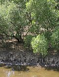
Muriqui is surrounded mostly by Atlantic Forest, which heavily influences its fauna and flora. [3] [31]

Hydrography

View of the Muriqui beach VISTA MURIQUI.jpg
View of the Muriqui beach

Beaches

Muriqui has direct access to the Atlantic Ocean through the Muriqui beach (Portuguese : Praia de Muriqui), located to the west of Sepetiba Bay  [ pt ] (Portuguese : Baía de Sepetiba). In terms of balneability, the Muriqui beach has been mostly deemed improper for bathing, [32] although there have been recent efforts in an attempt to clean Mangaratiba rivers and beaches. [33]

Rivers

Rio Catumbi's estuary. Rio-catumbi-estuary-1.jpg
Rio Catumbi's estuary.

Muriqui is centered between two rivers, with Rio Catumbi to the east and Rio Muriqui (sometimes called Rio da Prata) [34] to the west. [35]

To mitigate the risk of flooding, both rivers are periodically dredged by the district's subprefecture. [36] [37] [38]

Culture

Art

Muriqui is home to an art installation by Japanese artist Mariko Mori called Ring: One With Nature, inaugurated atop the Bride's Veil (Portuguese : Véu da Noiva) waterfall in August 2016 to celebrate the 2016 Summer Olympics. [39] The piece is an acrylic ring that changes in color depending on the position of the sun, and is meant as a representation of a sixth Olympic ring. It measures about 3 metres (9.8 ft) in diameter and weighs around 2 tonnes (4,400 lb). [40] [41]

Cuisine

A cocada of Muriqui. Cocada de Muriqui 1.png
A cocada of Muriqui.

Muriqui's most well known delicacy is the cocada (known as Cocada de Muriqui), deemed to be one of the famous sweets of the Mangaratiba cuisine. [42] According to Fabrini dos Santos, a SEBRAE consultant, the cocadas are distinctive enough that they could, at some point, be granted a geographical indication. [43] The district's cocada has existed at least since the construction of the BR-101 highway, and has been sold on its shoulders ever since. [44]

The coconut-based dessert has had such a cultural impact that, in March 2018, the "Cocada Party of Muriqui" (Portuguese : Festa da Cocada do Distrito de Muriqui) was added to the municipality's official event calendar, to be celebrated annually on the last weekend of the month of July. [44]

Folklore

Muriqui has its own folklore, limited to the region, and separate from the national-level folklore.

The story of the "Vieira Wind" (Portuguese : Vento Vieira) is part of the oral tradition of the district. The tale is usually related to the high-speed winds in the area during winter (roughly in the period from the end of August to the start of September). [45] [46]

According to the Brazilian Archaeology Institute  [ pt ] (Portuguese : Instituto de Arqueologia Brasileira, shortened IAB), there are two different versions of the story. [6] The first and more common one, which has been retold by Mangaratiba's official culture manager Fundação Mario Peixoto, [47] was described by local newspaper Jornal Litoral in 2015 as follows: [48]

The second version, arguably more grounded in reality, although less common, is as follows: [6]

Sport

Muriqui at Ajinomoto Stadium in 2016 Muriqui.jpg
Muriqui at Ajinomoto Stadium in 2016

Muriqui is the birthplace of a proeminent football player, Luiz Guilherme Silva, nicknamed Muriqui himself. [49] As of October 2020, he plays for Chinese Super League club Cangzhou Mighty Lions. [50] In 2018, he was elected the sixth most influential football player in China's history. [51]

Muriqui is also home to its own football club, Muriqui Football Club – along with the Muriqui Football Club Stadium (Portuguese : Estádio do Muriqui Futebol Clube). Among other events, it hosts the Municipal Veterans Championship (Portuguese: Campeonato Municipal de Veteranos). [52]

Notable people

Painting by Jose Leandro de Carvalho of king D. Joao VI, c. 1818 DomJoaoVI-pintordesconhecido.jpg
Painting by José Leandro de Carvalho of king D. João VI, c.1818

This is a non-exhaustive list of notable people born in Muriqui:

Notes

  1. Value given for area is not exact; it was calculated by using the known values for population and population density.
  2. Both "Rendon" and "Rendom" spellings of the surname can be found.
  3. The family name can be found spelled as "Alcarcon" and "Alarcão", and the surname can be found spelled as "Quevedo", "Oquevedo", "Equevedo" and "Quebedo".

Related Research Articles

<span class="mw-page-title-main">Rio de Janeiro (state)</span> State of Brazil

Rio de Janeiro is one of the 27 federative units of Brazil. It has the second largest economy of Brazil, with the largest being that of the state of São Paulo. The state, which has 8.2% of the Brazilian population, is responsible for 9.2% of the Brazilian GDP.

<span class="mw-page-title-main">Franca</span> Municipality in Southeast, Brazil

Franca is a municipality in the state of São Paulo, Brazil. The city is located in the northeastern portion of the state, distant 401 km from the state capital, and 676 km from Brasilia. It covers a total area of 605,679 km2 of which 86,92 km2 comprises the urban area. As of the 2021 Census, the city's population was 358,539.

<span class="mw-page-title-main">Teresópolis</span> Place in Southeast, Brazil

Teresópolis is a Brazilian municipality located in the state of Rio de Janeiro, in a mountainous region known as Região Serrana. The Serra dos Órgãos National Park lies partly within the city limits. The city is known as the home of the Brazil national football team, since it hosts CBF's training ground at Granja Comary.

<span class="mw-page-title-main">Andrelândia</span> Municipality in the state of Minas Gerais, Brazil

Andrelândia is a Brazilian municipality in the state of Minas Gerais that is located in the Mesoregion of South and Southwest of Minas and hosts the Microregion of Andrelândia. It is 300 km away from the state capital, Belo Horizonte and occupies an area of approximately 1 005 km2. In 2014 its population was estimated at 12 507 inhabitants, being the 296th most populous municipality in the state of Minas Gerais and the second of its microregion.

<span class="mw-page-title-main">Angra dos Reis</span> Municipality in Rio de Janeiro state, Brazil

Angra dos Reis is a municipality located in the southern part of the Brazilian state of Rio de Janeiro. The city is located by the sea and includes in its territory many offshore islands, the largest being Ilha Grande.

<span class="mw-page-title-main">Jacarezinho, Rio de Janeiro</span> Neighborhood in Rio de Janeiro, Rio de Janeiro, Brazil

Jacarezinho is a favela in Rio de Janeiro, with more than 60,300 residents living in an area of 40 hectares. It is located in the North Zone of the city, and borders the neighborhoods of Jacaré, Méier, Engenho Novo and Triagem. It is the third-largest favela in Rio de Janeiro, behind Rocinha and Complexo do Alemão. The favela expanded as the city industrialized, and it became the biggest favela in Rio de Janeiro by the mid-20th century, with a population of 23,000 in 1960. The crucial element in its growth was the industrial boom in the nearby Méier district after World War II, according to the historian Julio Cesar Pino, author of a book about the favelas of Rio de Janeiro.

<span class="mw-page-title-main">Rodrigo de Freitas Lagoon</span> Lagoon in Rio de Janeiro, Brazil

Rodrigo de Freitas Lagoon is a lagoon in the district of Lagoa in the Zona Sul area of Rio de Janeiro. The lagoon is connected to the Atlantic Ocean, allowing sea water to enter by a canal along the edge of a park locally known as Jardim de Alah.

<span class="mw-page-title-main">Itaboraí</span> Municipality in Southeast, Brazil

Itaboraí is a city in the state of Rio de Janeiro in Brazil, that belongs to the Rio de Janeiro metropolitan area. It was founded in 1672. In 2020, it had a population of 242,543.

<span class="mw-page-title-main">Cachoeiras de Macacu</span> Municipality in Southeast, Brazil

Cachoeiras de Macacu is a municipality located in the Brazilian state of Rio de Janeiro. Its population was 59,303 (2020) and its area is 956 km². Next to neighboring Rio Bonito municipality, it can be considered an exurb of Greater Rio de Janeiro metropolis.

<span class="mw-page-title-main">Guapimirim</span> Municipality in Southeast, Brazil

Guapimirim, is municipality in the Brazilian state of Rio de Janeiro around 50 km(31 miles) from its state capital, the city of Rio de Janeiro. Its in a region known as Baixada Fluminense and the Greater Rio de Janeiro metropolitan area.

<span class="mw-page-title-main">Mangaratiba</span> Municipality in Southeast, Brazil

Mangaratiba is a municipality located in the Brazilian state of Rio de Janeiro. Its population is 45,220 (2020) and its area is 352 km2.

<span class="mw-page-title-main">São José do Vale do Rio Preto</span> Municipality

São José do Vale do Rio Preto is a municipality located in the Brazilian state of Rio de Janeiro. Its population was 21,916 (2020) and its area is 240 km2.

<span class="mw-page-title-main">Valença, Rio de Janeiro</span> Municipality in Southeast, Brazil

Valença is a municipality located in the Brazilian state of Rio de Janeiro. Its population was estimated at 76,869 in 2020 and its area is 1,305 square kilometres (504 sq mi). The city is the seat of the Roman Catholic Diocese of Valença.

<span class="mw-page-title-main">São Pedro de Alcântara, Santa Catarina</span> Municipality in South, Brazil

São Pedro de Alcântara, Santa Catarina is a municipality in the state of Santa Catarina in the South region of Brazil.

Major Vieira is a municipality in the state of Santa Catarina in the South region of Brazil.

<span class="mw-page-title-main">Faxinal dos Guedes</span> City in South, Brazil

Faxinal dos Guedes is a municipality located in the west of the state of Santa Catarina, in the South Region of Brazil. Its population, according to the 2022 Brazilian Institute of Geography and Statistics Census, was 11 192 inhabitants. With an area of 340,070 km2, part of its territory is located on the western edge of a meteoritic crater, the Vargeão Dome.

<span class="mw-page-title-main">Bom Jesus do Araguaia</span> Municipality in Center-West, Brazil

Bom Jesus do Araguaia is a municipality in the state of Mato Grosso in the Central-West Region of Brazil.

Rosário do Ivaí is a municipality in the state of Paraná in the Southern Region of Brazil. The inhabitants are called Rosarienses. The municipality extends over 371.3 km² and had 4,786 inhabitants in the last census. The demographic density is 12.9 inhabitants per km² in the municipality’s territory.

<span class="mw-page-title-main">Praia do Sul Biological Reserve</span>

Praia do Sul State Biological Reserve is a biological reserve on the island of Ilha Grande, in the State of Rio de Janeiro, in Brazil.

<span class="mw-page-title-main">Tamoios Environmental Protection Area</span> Protected area in Rio de Janeiro, Brazil

The Tamoios Environmental Protection Area is an environmental protection area of the state of Rio de Janeiro, Brazil. It protects an area of coastal forests, mangroves, rocky shores and islands.

References

  1. 1 2 3 4 "IBGE | Censo 2010 | Sinopse por Setores". IBGE . Retrieved 2020-02-13.
  2. 1 2 3 "Modelo Digital de Elevação - MDE". IBGE . Retrieved 2020-02-13.
  3. 1 2 "Plano de Manejo da Área de Proteção Ambiental de Mangaratiba". Rio de Janeiro: INEA  [ pt ]. 2015-09-11. Retrieved 2020-02-16.
  4. "Muriqui | Prefeitura de Mangaratiba". Archived from the original on 2020-01-12. Retrieved 2020-02-10.
  5. "Festa da padroeira de Muriqui, movimenta fim de semana" [Celebration of Muriqui's patron saint drives weekend]. Jornal Litoral (in Brazilian Portuguese) (5th ed.). Mangaratiba. December 2015. p. 10. Retrieved 2020-12-18 via Issuu.
  6. 1 2 3 "Levantamento do Patrimônio Cultural Imaterial" [Research of the Intangible Cultural Heritage]. Brazilian Archaeology Institute  [ pt ]. Programa de Pesquisas Arqueológicas, de Educação Patrimonial, Levantamento do Patrimônio Cultural Imaterial e Estudos de Elementos de Arquitetura Histórica na Estrada RJ-149 – Rio Claro-Mangaratiba – Estrada do Imperador (in Brazilian Portuguese).
  7. 1 2 Rodriguez, Helio Suêvo (2004). As Formações das Estradas de Ferro no Rio de Janeiro: O Resgate da sua Memória [The Formation of Railroads in Rio de Janeiro: The Rescue of their Memory] (in Brazilian Portuguese). Memória do Trem. p. 72. ISBN   85-86094-07-2.
  8. Sampaio, Teodoro (1987) [First published 1901]. O Tupi na Geografia Nacional [The Tupi on National Geography]. Brasiliana Eletrônica da UFRJ (in Brazilian Portuguese). Vol. 380. Introduction and notes by Frederico G. Edelweiss (5th ed.). Companhia Editora Nacional  [ pt ]. p. 209. ISBN   85-04-00212-8. Archived (PDF) from the original on 2021-06-03. Retrieved 2022-01-24.
  9. Pissinatti, Alcides (December 2005). "Management of Muriquis (Brachyteles, primates) in Captivity". Neotropical Primates. 13 (Supplement). IUCN/SSC Primate Specialist Group: 93. doi:10.1896/ci.cabs.2005.np.13.suppl (inactive 1 November 2024). ISSN   1413-4705 . Retrieved 2020-02-12.{{cite journal}}: CS1 maint: DOI inactive as of November 2024 (link)
  10. von Martius, Karl Friedrich Philipp (1867). Beiträge zur Ethnographie und Sprachenkunde Amerika's zumal Brasiliens. Vol. 2. Leipzig: Friedrich Fleisher. p. 516. Archived (PDF) from the original on 2020-02-17.{{cite book}}: |website= ignored (help)
  11. "Plano Municipal de Educação - Documento Base" (PDF). Ministério Público do Rio de Janeiro  [ pt ] (in Brazilian Portuguese). 2015. Retrieved 2020-09-18.
  12. Bondim, Mirian. "História". Prefeitura de Mangaratiba (in Brazilian Portuguese). Retrieved 2020-09-18.
  13. 1 2 Mello, Carl Egbert H. Vieira de (1996). O Rio de Janeiro no Brasil Quinhentista (in Brazilian Portuguese). São Paulo. pp. 153–155. Retrieved 2020-09-18.{{cite book}}: CS1 maint: location missing publisher (link)
  14. Knivet, Anthony (1906). Purchas, Samuel (ed.). Hakluytus Posthumus or Purchas His Pilgrimes. Vol. XVI. p. 234. Archived (PDF) from the original on 2020-08-11. Retrieved 2020-09-18.{{cite book}}: |website= ignored (help)
  15. 1 2 "Revista do Instituto Histórico e Geográfico Brasileiro" [Brazilian Historic and Geographic Institute Magazine]. Revista do Instituto Historico e Geographico Brazileiro (in Brazilian Portuguese) (17). Brazilian Historic and Geographic Institute. 1854. ISSN   0101-4366. Archived from the original on 2022-01-25. Retrieved 2022-01-25.
  16. 1 2 Bondim, Mirian (October 2015). "Resumo da História Econômica e Social de Mangaratiba" [Summary of the Social and Economic History of Mangaratiba](PDF). Prefeitura de Mangaratiba (in Brazilian Portuguese). p. 16. Retrieved 2020-09-18.
  17. "Faça as malas e venha para cá!" [Pack up and come here!]. Prefeitura de Mangaratiba (in Brazilian Portuguese). Archived from the original on 2020-09-04. Retrieved 2022-01-24.
  18. Bicalho, Maria Fernanda (2013). "Redesenhando fronteiras, ampliando jurisdições: O Rio de Janeiro no período filipino" (PDF). Associação Nacional de História  [ pt ] (in Brazilian Portuguese). Natal . Retrieved 2020-09-18.
  19. Leme, Pedro Taques de Almeida Paes (1869). Nobiliarquia Paulistana: Genealogia das Principaes Famílias de S. Paulo (in Brazilian Portuguese). Rio de Janeiro. pp. 187–188 (PDF pp. 856–857). Retrieved 2020-09-18.{{cite book}}: |website= ignored (help)CS1 maint: location missing publisher (link)
  20. Leme, Luiz Gonzaga da Silva (1905). Genealogia Paulistana. Vol. 9º. São Paulo. pp. 24–25. Retrieved 2020-09-18 via Internet Archive.{{cite book}}: CS1 maint: location missing publisher (link)
  21. "IBGE | Cidades@ | Rio de Janeiro | Mangaratiba | História & Fotos". IBGE . Archived from the original on 2018-06-26. Retrieved 2020-02-10.
  22. "Atos da Prefeitura" (PDF). Boletim Informativo Oficial do Município de Mangaratiba (in Brazilian Portuguese) (329): 10. 2012-01-12. Retrieved 2020-12-03.
  23. "Atos da Prefeitura" (PDF). Boletim Informativo Oficial do Município de Mangaratiba (in Brazilian Portuguese) (399 - Suplemento Especial): 32. 2013-06-20. Retrieved 2020-12-03.
  24. "Atos da Prefeitura" (PDF). Diário Oficial do Município de Mangaratiba (in Brazilian Portuguese) (519): 5. 2015-06-03. Retrieved 2020-12-03.
  25. "Atos da Prefeitura" (PDF). Diário Oficial do Município de Mangaratiba (in Brazilian Portuguese) (686): 13. 2017-04-07. Retrieved 2020-12-03.
  26. "Atos da Prefeitura" (PDF). Diário Oficial do Município de Mangaratiba (in Brazilian Portuguese) (838): 82. 2018-07-31. Retrieved 2020-12-03.
  27. "Atos da Prefeitura" (PDF). Diário Oficial do Município de Mangaratiba (in Brazilian Portuguese) (848): 36. 2018-08-31. Retrieved 2020-12-03.
  28. "Atos da Prefeitura" (PDF). Diário Oficial do Município de Mangaratiba (in Brazilian Portuguese) (880): 20. 2018-12-18. Retrieved 2020-12-02.
  29. 1 2 "Atos da Prefeitura" (PDF). Diário Oficial do Município de Mangaratiba (in Brazilian Portuguese) (917): 5. 2019-04-26. Retrieved 2020-12-02.
  30. "Atos da Prefeitura" (PDF). Diário Oficial do Município de Mangaratiba (in Brazilian Portuguese) (1069): 20. 2020-01-29. Retrieved 2020-12-02.
  31. Barreiros, Humberto de Souza (June 1980). "Excursão a Vila Muriqui" [Excursion to Vila Muriqui]. Rodriguésia  [ es ] (in Brazilian Portuguese). Vol. 32, no. 53. Rio de Janeiro Botanical Garden. pp. 319–320. doi:10.1590/2175-78601980325315. ISSN   2175-7860. Archived from the original on 2022-01-25. Retrieved 2022-01-24.
  32. "Três em dez praias são impróprias para banho no Brasil; pesquise" [Three in ten beaches are unsuited for bathing in Brazil; look up]. Folha de S.Paulo (in Brazilian Portuguese). 2017-02-05. Retrieved 2020-09-05.
  33. Neves, Rafaela (2019-12-18). "Prefeitura inicia implantação de fossas biodigestoras" [Town hall starts implementing digesters]. Mangaratiba Town Hall (Portuguese: Prefeitura de Mangaratiba) (in Brazilian Portuguese). Retrieved 2020-09-05.
  34. Bidegain, Paulo; Pellens, Roseli; Jamel, Carlos Eduardo Goes (July 1998), A Situação Atual dos Espaços Territoriais Protegidos do Estado do Rio de Janeiro: Parte II [The Current Situation of Protected Territories of the State of Rio de Janeiro: Part II] (in Brazilian Portuguese), p. 110, retrieved 2020-02-16
  35. Lopes, Monique Oliveira (2014-04-11). Diagnóstico Ambiental dos Rios da Prata e Catumbi e Balneabilidade da Praia: Estudo de Caso em Muriqui, Mangaratiba - Rj (MSc) (in Brazilian Portuguese). UERJ . Retrieved 2020-02-16.
  36. "Rio em Muriqui é dragado" [River in Muriqui is dredged] (in Brazilian Portuguese). 2012-12-22. Archived from the original on 2020-02-16. Retrieved 2020-02-16.
  37. "Limpeza no Rio Muriqui" [Cleanup on Rio Muriqui] (in Brazilian Portuguese). 2015-06-16. Archived from the original on 2020-02-16. Retrieved 2020-02-16.
  38. Assis, Caio (2016-06-06). "Desobstrução do Rio Muriqui" [Deobstructing of Rio Muriqui] (in Brazilian Portuguese). Retrieved 2020-02-16.
  39. Plummer, Todd (2016-08-08). "Artist Mariko Mori Explains Her Stunning Rio 2016 Art Installation". Vogue . Retrieved 2020-09-04.
  40. Guimarães, Ana Cláudia (2016-07-13). "Cachoeira em Mangaratiba (RJ) ganhará 'auréola gigante' feita por artista japonesa" [Waterfall in Mangaratiba (RJ) will get 'giant halo' made by japanese artist]. O Globo (in Brazilian Portuguese). Retrieved 2020-09-04.
  41. "Parque Estadual Cunhambebe inaugura trilha adaptada para portadores de necessidades especiais" [Cunhambebe State Park inaugurates trail adapted for the disabled]. INEA  [ pt ] (in Brazilian Portuguese). 2017-07-18. Retrieved 2020-09-04.
  42. Popov, Flávia, ed. (2018-04-02). "És princesinha colossal da Costa Verde". O Hoje.com (in Brazilian Portuguese). Retrieved 2020-09-28.
  43. Guimarães, Saulo Pereira (2019-12-15). "Laranjas e vieiras com 'pedigree' lutam por selo de certificação". O Globo (in Brazilian Portuguese). Retrieved 2020-09-28.
  44. 1 2 Araújo, Helder Rangel de (2018-03-27). "Projeto de Lei Nº 10/2018" (PDF). Câmara Municipal de Mangaratiba (in Brazilian Portuguese). Retrieved 2020-09-28.
  45. "Average Weather in Mangaratiba, Brazil". Weather Spark. Retrieved 2020-09-04.
  46. "Relatório da Qualidade do Ar do Estado do Rio de Janeiro - Ano Base 2015" [State of Rio de Janeiro's Air Quality Report - Base Year 2015](PDF). Instituto Estadual do Ambiente  [ pt ] (in Brazilian Portuguese). 2016. p. 119. Retrieved 2020-09-04.
  47. "Encerrando a nossa Semana do Folclore, vamos contar a lenda do Vento Vieira" [To end Folklore Week, we'll tell the tale of Vieira Wind]. Fundação Mario Peixoto (in Brazilian Portuguese). Instagram. 2018-08-24. Archived from the original on 2021-12-26. Retrieved 2020-09-04.
  48. "Curiosidades da cidade: A história do vento Vieira" [City's curiosities: The story of the Vieira wind]. Jornal Litoral (in Brazilian Portuguese) (2nd ed.). Mangaratiba. April 2015. p. 12. Retrieved 2020-09-04 via Issuu.
  49. Schmidt, Felipe; Angeli, Raphael de (10 January 2017). ""Dívida" no Vasco, Gabriel e Conca: o novo Muriqui conta sua história". Globo Esporte (in Brazilian Portuguese). Rio de Janeiro . Retrieved 11 May 2021.
  50. Reis, Rafael (7 October 2020). "Por onde andam 7 ex-jogadores do Vasco que estão "escondidos" no exterior?". UOL (in Brazilian Portuguese).
  51. Camargo, Matheus (14 March 2018). ""Eu tenho noção do que represento aqui", afirma Muriqui, ídolo do futebol chinês". Torcedores.com. Retrieved 11 May 2021.
  52. Bernard, Claud (23 June 2016). "Futebol para Veteranos" (in Brazilian Portuguese). Retrieved 11 May 2021.
  53. José Leandro de Carvalho (in Brazilian Portuguese). Itaú Cultural. 2022. ISBN   978-85-7979-060-7 . Retrieved 31 May 2021.{{cite book}}: |website= ignored (help)
  54. Santos, Presalindo de Lery [in Portuguese] (1880). Pantheon fluminense: esboços biographicos (in Brazilian Portuguese). Rio de Janeiro: Typ. G. Leuzinger & Filhos. p. 463. Retrieved 31 May 2021.

Bibliography

Further reading