Museum, Kansas

Last updated
Museum, Kansas
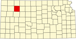
Map of Sheridan Co, Ks, USA.png
USA Kansas location map.svg
Red pog.svg
Museum
Usa edcp location map.svg
Red pog.svg
Museum
Coordinates: 39°19′55″N100°14′08″W / 39.33194°N 100.23556°W / 39.33194; -100.23556
Country United States
State Kansas
County Sheridan
Elevation
2,451 ft (747 m)
Population
  Total0
Time zone UTC-6 (CST)
  Summer (DST) UTC-5 (CDT)
Area code 785
GNIS ID 482593 [1]

Museum is a ghost town in Sheridan County, Kansas, United States.

Contents

History

Museum was issued a post office in 1882. The post office was discontinued in 1898. [2]

Related Research Articles

<span class="mw-page-title-main">Sheridan County, Kansas</span> County in Kansas, United States

Sheridan County is a county located in the U.S. state of Kansas. Its county seat is Hoxie. As of the 2020 census, the county population was 2,447. The county was named in honor of Phillip Sheridan, a general during the American Civil War.

<span class="mw-page-title-main">Decatur County, Kansas</span> County in Kansas, United States

Decatur County is a county located in Northwest Kansas. Its county seat and most populous city is Oberlin. As of the 2020 census, the county population was 2,764. The county was named in honor of Stephen Decatur, Jr., a commodore in the United States Navy who served during both Barbary Wars in North Africa, the Quasi-War with France, and the War of 1812 with Britain.

<span class="mw-page-title-main">Sheridan, Colorado</span> City in Colorado, United States

The City of Sheridan is a home rule municipality located in Arapahoe County, Colorado, United States. Sheridan is a part of the Denver–Aurora–Lakewood, CO Metropolitan Statistical Area. The population was 6,105 at the 2020 census.

<span class="mw-page-title-main">Sheridan Lake, Colorado</span> Town in Colorado, United States

Sheridan Lake is a Statutory Town located in Kiowa County, Colorado, United States. The population was 55 at the 2020 census.

<span class="mw-page-title-main">Sheridan, Wyoming</span> City in Wyoming, United States

Sheridan is a city in the U.S. state of Wyoming and the county seat of Sheridan County. The city is located halfway between Yellowstone Park and Mount Rushmore by U.S. Route 14 and 16. It is the principal town of the Sheridan, Wyoming, Micropolitan Statistical Area which encompasses all of Sheridan County. The 2020 census put the city's population at 18,737, making it the 6th most populous city in Wyoming.

<span class="mw-page-title-main">Towner, Colorado</span> Census-designated place in Kiowa County, Colorado, United States

Towner is a census-designated place (CDP) in and governed by Kiowa County, Colorado, United States. The population of the Towner CDP was 18 at the United States Census 2020. The Sheridan Lake post office serves Towner postal addresses. Towner's post office closed down in 1992.

<span class="mw-page-title-main">Franklin, Kansas</span> Unincorporated community in Crawford County, Kansas

Franklin is an unincorporated community in Crawford County, Kansas, United States. As of the 2020 census, the population of the community and nearby areas was 473. Franklin is located along U.S. Route 69, 1 mile (1.6 km) south of Arma, or 5.9 miles (9.5 km) north of Frontenac.

<span class="mw-page-title-main">Angelus, Kansas</span> Unincorporated community in Sheridan County, Kansas

Angelus is an unincorporated community in Sheridan County, Kansas, United States. It is located in Solomon Township, approximately 20 miles southwest of Hoxie. Also, it is located northwest of Grinnell and Interstate 70.

<span class="mw-page-title-main">Seguin, Kansas</span> Unincorporated community in Sheridan County, Kansas

Seguin is an unincorporated community in Sheridan County, Kansas, United States. It is located in Logan Township, approximately 10 miles west of Hoxie. It lies south of U.S. Route 24, to which it is linked by Kansas Highway 188.
<span class="mw-page-title-main">Studley, Kansas</span> Unincorporated community in Sheridan County, Kansas

Studley is an unincorporated community in Sheridan County, Kansas, United States, approximately 16 miles east of Hoxie along U.S. Route 24. It is on the eastern edge of the county in Valley Township, bordering Graham County. It was named after the Studley Royal Park, in England.

<span class="mw-page-title-main">Lucerne, Kansas</span> Ghost town in Sheridan County, Kansas

Lucerne is a ghost town in Adell Township, Sheridan County, Kansas, United States. It is approximately 18 miles northeast of the county seat of Hoxie.

<span class="mw-page-title-main">Chicago, Kansas</span> Ghost town in Sheridan County, Kansas

Chicago is a ghost town in Adell Township, Sheridan County, Kansas, United States.

<span class="mw-page-title-main">Adell, Kansas</span> Ghost town in Sheridan County, Kansas

Adell is a ghost town in Sheridan County, Kansas, United States.

<span class="mw-page-title-main">Alcyone, Kansas</span> Ghost town in Sheridan County, Kansas

Alcyone is a ghost town in Sheridan County, Kansas, United States.

<span class="mw-page-title-main">Mystic, Kansas</span> Ghost town in Sheridan County, Kansas

Mystic is a ghost town in Sheridan County, Kansas, United States.

<span class="mw-page-title-main">Phelps, Kansas</span> Ghost town in Sheridan County, Kansas

Phelps is a ghost town in Sheridan County, Kansas, United States.

<span class="mw-page-title-main">Sheridan, Kansas</span> Ghost town in Sheridan County, Kansas

Sheridan is a ghost town in Sheridan County, Kansas, United States.

<span class="mw-page-title-main">Ute, Kansas</span> Ghost town in Sheridan County, Kansas

Ute is a ghost town in Sheridan County, Kansas, United States.

<span class="mw-page-title-main">Violenta, Kansas</span> Ghost town in Sheridan County, Kansas

Violenta is a ghost town in Sheridan County, Kansas, United States.

<span class="mw-page-title-main">Tasco, Kansas</span> Unincorporated community in Sheridan County, Kansas

Tasco is an unincorporated community in Sheridan County, Kansas, United States. It is located about 7 miles east of Hoxie and south of U.S. Route 24 highway, next to an abandoned railroad.

References

  1. "US Board on Geographic Names". United States Geological Survey. 1984-07-01. Retrieved 2017-12-30.
  2. "Kansas Post Offices, 1828-1961". Kansas Historical Society. Retrieved 2018-01-02.[ permanent dead link ]

Further reading