National Register of Historic Places listings in Morrill County, Nebraska

Last updated
Location of Morrill County in Nebraska Map of Nebraska highlighting Morrill County.svg
Location of Morrill County in Nebraska

This is a list of the National Register of Historic Places listings in Morrill County, Nebraska.

Contents

This is intended to be a complete list of the properties and districts on the National Register of Historic Places in Morrill County, Nebraska, United States. The locations of National Register properties and districts for which the latitude and longitude coordinates are included below may be seen in a map. [1]

There are 8 properties and districts listed on the National Register in the county.

This National Park Service list is complete through NPS recent listings posted January 7, 2022. [2]
Map all coordinates using: OpenStreetMap  
Download coordinates as: KML

Current listings

[3] Name on the Register [4] ImageDate listed [5] Location City or townDescription
1 Camp Clarke Bridge Site
Camp Clarke Bridge Site Camp Clarke bridge site view from N.JPG
Camp Clarke Bridge Site
November 8, 1974
(#74001129)
West of Bridgeport
41°41′24″N103°10′43″W / 41.69°N 103.178611°W / 41.69; -103.178611 (Camp Clarke Bridge Site)
Bridgeport Site of a wooden toll bridge built in 1875 to serve the Dakota gold fields.
2 Chimney Rock National Historic Site
Chimney Rock National Historic Site P7170202 Chimney Rock.JPG
Chimney Rock National Historic Site
October 15, 1966
(#66000116)
3 miles (4.8 km) southwest of Bayard
41°42′09″N103°20′49″W / 41.7025°N 103.346944°W / 41.7025; -103.346944 (Chimney Rock National Historic Site)
Bayard
3 Courthouse and Jail House Rocks
Courthouse and Jail House Rocks Courthouse jail rocks.JPG
Courthouse and Jail House Rocks
April 24, 1973
(#73001067)
5 miles (8.0 km) south of Bridgeport
41°36′02″N103°07′00″W / 41.600556°N 103.116667°W / 41.600556; -103.116667 (Courthouse and Jail House Rocks)
Bridgeport
4 Greenwood Stage Station March 13, 2012
(#12000106)
Appr. location
41°30′07″N103°04′57″W / 41.501994°N 103.0825°W / 41.501994; -103.0825 (Greenwood Stage Station)
Bridgeport
5 Morrill County Courthouse
Morrill County Courthouse Morrill County, Nebraska courthouse from SE 2.JPG
Morrill County Courthouse
January 10, 1990
(#89002227)
Main St. between 6th and 7th Sts.
41°40′07″N103°06′00″W / 41.66864°N 103.10006°W / 41.66864; -103.10006 (Morrill County Courthouse)
Bridgeport
6 Mud Springs Station Archeological District
Mud Springs Station Archeological District Mud Springs Station monument 2.JPG
Mud Springs Station Archeological District
April 24, 1973
(#73001068)
County road 107 between 68 and 70 [6]
41°29′04″N103°01′02″W / 41.4845°N 103.01712°W / 41.4845; -103.01712 (Mud Springs Station Archeological District)
Dalton Originally listed as "Mud Springs Pony Express Station Site"; boundaries increased on September 6, 2011 [4]
7 Rush Creek Battlefield
Rush Creek Battlefield Cedar Creek (Morrill Co, NE) DS from CR78.JPG
Rush Creek Battlefield
September 6, 2011
(#11000619)
Southern side of the Platte River at the mouth of Rush Creek [7]
41°33′05″N102°48′45″W / 41.551389°N 102.812500°W / 41.551389; -102.812500 (Rush Creek Battlefield)
Broadwater
8 Schuetz Log Cabin
Schuetz Log Cabin Schuetz Log Cabin.jpg
Schuetz Log Cabin
March 21, 2011
(#11000105)
HC 82 Box 103
41°29′57″N103°05′17″W / 41.499167°N 103.088056°W / 41.499167; -103.088056 (Schuetz Log Cabin)
Dalton A settler family's log cabin, built during 1900-20.

See also

Related Research Articles

National Register of Historic Places listings in Tompkins County, New York

List of the National Register of Historic Places listings in Tompkins County, New York

National Register of Historic Places listings in Botetourt County, Virginia

This is a list of the National Register of Historic Places listings in Botetourt County, Virginia.

National Register of Historic Places listings in Platte County, Nebraska

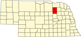
This is a list of the National Register of Historic Places listings in Platte County, Nebraska. It is intended to be a complete list of the properties and districts on the National Register of Historic Places in Platte County, Nebraska, United States. The locations of National Register properties and districts for which the latitude and longitude coordinates are included below, may be seen in a map.

National Register of Historic Places listings in Washington County, Nebraska

This is a list of the National Register of Historic Places listings in Washington County, Nebraska.

National Register of Historic Places listings in Richardson County, Nebraska

This is a list of the National Register of Historic Places listings in Richardson County, Nebraska.

National Register of Historic Places listings in Cass County, Nebraska

This is a list of the National Register of Historic Places listings in Cass County, Nebraska.

National Register of Historic Places listings in Cedar County, Nebraska

This is a list of the National Register of Historic Places listings in Cedar County, Nebraska.

National Register of Historic Places listings in Adams County, Nebraska

This is a list of the National Register of Historic Places listings in Adams County, Nebraska.

National Register of Historic Places listings in Butler County, Nebraska

This is a list of the National Register of Historic Places listings in Butler County, Nebraska. It is intended to be a complete list of the properties and districts on the National Register of Historic Places in Butler County, Nebraska, United States. The locations of National Register properties and districts for which the latitude and longitude coordinates are included below, may be seen in a map.

National Register of Historic Places listings in Gage County, Nebraska

This is a list of the National Register of Historic Places listings in Gage County, Nebraska.

National Register of Historic Places listings in Hall County, Nebraska

This is a list of the National Register of Historic Places listings in Hall County, Nebraska.

National Register of Historic Places listings in Lancaster County, Nebraska

This is a list of the National Register of Historic Places listings in Lancaster County, Nebraska.

National Register of Historic Places listings in Colfax County, Nebraska

This is a list of the National Register of Historic Places listings in Colfax County, Nebraska.

National Register of Historic Places listings in Burt County, Nebraska

This is a list of the National Register of Historic Places listings in Burt County, Nebraska.

National Register of Historic Places listings in Antelope County, Nebraska

This is a list of the National Register of Historic Places listings in Antelope County, Nebraska.

National Register of Historic Places listings in Seward County, Nebraska

This is a list of the National Register of Historic Places listings in Seward County, Nebraska. It is intended to be a complete list of the properties and districts on the National Register of Historic Places in Seward County, Nebraska, United States. The locations of National Register properties and districts for which the latitude and longitude coordinates are included below, may be seen in a map.

National Register of Historic Places listings in Lincoln County, Nebraska

This is a list of the National Register of Historic Places listings in Lincoln County, Nebraska. It is intended to be a complete list of the properties and districts on the National Register of Historic Places in Lincoln County, Nebraska, United States. The locations of National Register properties and districts for which the latitude and longitude coordinates are included below, may be seen in a map.

National Register of Historic Places listings in Red Willow County, Nebraska

This is a list of the National Register of Historic Places listings in Red Willow County, Nebraska.

National Register of Historic Places listings in Sheridan County, Nebraska

This is a list of the National Register of Historic Places listings in Sheridan County, Nebraska.

National Register of Historic Places listings in Madison County, Nebraska

This is a list of the National Register of Historic Places listings in Madison County, Nebraska.

References

  1. The latitude and longitude information provided in this table was derived originally from the National Register Information System, which has been found to be fairly accurate for about 99% of listings. Some locations in this table may have been corrected to current GPS standards.
  2. National Park Service, United States Department of the Interior, "National Register of Historic Places: Weekly List Actions", retrieved January 7, 2022.
  3. Numbers represent an alphabetical ordering by significant words. Various colorings, defined here, differentiate National Historic Landmarks and historic districts from other NRHP buildings, structures, sites or objects.
  4. 1 2 "National Register Information System". National Register of Historic Places . National Park Service. July 9, 2010.
  5. The eight-digit number below each date is the number assigned to each location in the National Register Information System database, which can be viewed by clicking the number.
  6. Driving directions to Mud Springs are at "Mud Springs Pony Express Station Site", National Park Service, retrieved 2013-04-25. The site is marked as "Pony Express Marker" on the Morrill County S map, Nebraska Department of Roads, retrieved 2013-04-25.
  7. "Fort Laramie National Historic Site Hosts Program on Mud Spring and Rush Creek Battles". Gering Citizen 2011-07-14. Accessed 2013-04-18.