The Oregon Trail was a 2,170-mile (3,490 km) east–west, large-wheeled wagon route and emigrant trail in the United States that connected the Missouri River to valleys in Oregon. The eastern part of the Oregon Trail spanned part of what is now the state of Kansas and nearly all of what are now the states of Nebraska and Wyoming. The western half of the trail spanned most of the current states of Idaho and Oregon.

The South Platte River is one of the two principal tributaries of the Platte River. Flowing through the U.S. states of Colorado and Nebraska, it is itself a major river of the American Midwest and the American Southwest/Mountain West. Its drainage basin includes much of the eastern flank of the Rocky Mountains in Colorado, much of the populated region known as the Colorado Front Range and Eastern Plains, and a portion of southeastern Wyoming in the vicinity of the city of Cheyenne. It joins the North Platte River in western Nebraska to form the Platte, which then flows across Nebraska to the Missouri. The river serves as the principal source of water for eastern Colorado. In its valley along the foothills in Colorado, it has permitted agriculture in an area of the Colorado Piedmont and Great Plains that is otherwise arid.

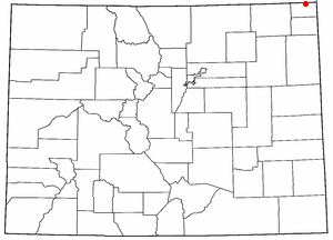
Morrill County is a county in the U.S. state of Nebraska. As of the 2010 United States Census, the population was 5,042. Its county seat is Bridgeport.

Fort Caspar was a military post of the United States Army in present-day Wyoming, named after 2nd Lieutenant Caspar Collins, a U.S. Army officer who was killed in the 1865 Battle of the Platte Bridge Station against the Lakota and Cheyenne. Founded in 1859 along the banks of the North Platte River as a trading post and toll bridge on the Oregon Trail, the post was later taken over by the Army and named Platte Bridge Station to protect emigrants and the telegraph line against raids from Lakota and Cheyenne in the ongoing wars between those nations and the United States. The site of the fort, near the intersection of 13th Street and Wyoming Boulevard in Casper, Wyoming, is listed in the National Register of Historic Places and is now owned and operated by the City of Casper as the Fort Caspar Museum and Historic Site.

Fort Kearny was a historic outpost of the United States Army founded in 1848 in the western U.S. during the middle and late 19th century. The fort was named after Col. and later General Stephen Watts Kearny. The outpost was located along the Oregon Trail near Kearney, Nebraska. The town of Kearney took its name from the fort. The "e" was added to Kearny by postmen who consistently misspelled the town name. A portion of the original site is preserved as Fort Kearny State Historical Park by the Nebraska Game and Parks Commission.

The Sioux Wars were a series of conflicts between the United States and various subgroups of the Sioux people which occurred in the later half of the 19th century. The earliest conflict came in 1854 when a fight broke out at Fort Laramie in Wyoming, when Sioux warriors killed 31 American soldiers in the Grattan Massacre, and the final came in 1890 during the Ghost Dance War.

The Colorado War was an Indian War fought in 1864 and 1865 between the Southern Cheyenne, Arapaho, and allied Brulé and Oglala Sioux peoples versus the U.S. army, Colorado militia, and white settlers in Colorado Territory and adjacent regions. The Kiowa and the Comanche played a minor role in actions that occurred in the southern part of the Territory along the Arkansas River. The Cheyenne, Arapaho, and Sioux played the major role in actions that occurred north of the Arkansas River and along the South Platte River, the Great Platte River Road, and the eastern portion of the Overland Trail. The United States government and Colorado Territory authorities participated through the 1st Colorado Cavalry Regiment, often called the Colorado volunteers. The war was centered on the Colorado Eastern Plains, extending eastward into Kansas and Nebraska.

Courthouse and Jail Rocks are two rock formations located near Bridgeport in the Nebraska Panhandle.

The Great Platte River Road was a major overland travel corridor approximately following the course of the Platte River in present-day Nebraska and Wyoming that was shared by several popular emigrant trails during the 19th century, including the Trapper's Trail, the Oregon Trail, the Mormon Trail, the California Trail, the Pony Express route, and the military road connecting Fort Leavenworth and Fort Laramie. The road, which extended nearly 800 miles (1,300 km) from the Second Fort Kearny to Fort Laramie, was utilized primarily from 1841 to 1866. In modern times it is often regarded as a sort of superhighway of its era, and has been referred to as "the grand corridor of America's westward expansion".

Fort Sidney is a historic fort located in Sidney, Nebraska, United States. The 37th Infantry Regiment established "Sidney Station" at a point midway between the Platte Rivers, where the modern community of Sidney, Nebraska, now stands. Initially the installation was a block house on a bluff with soldiers residing in tents nearby. That Spring, Fort Sedgewick, Colorado, was abandoned and the wooden buildings moved by mule train to a location beneath the bluffs and on the Lodgepole creek. This new garrison was named Sidney Barracks and would remain so until 1879, when it was designated Fort Sidney.
The Overland Trail was a stagecoach and wagon trail in the American West during the 19th century. While portions of the route had been used by explorers and trappers since the 1820s, the Overland Trail was most heavily used in the 1860s as a route alternative to the Oregon, California, and Mormon trails through central Wyoming. The Overland Trail was famously used by the Overland Stage Company owned by Ben Holladay to run mail and passengers to Salt Lake City, Utah, via stagecoaches in the early 1860s. Starting from Atchison, Kansas, the trail descended into Colorado before looping back up to southern Wyoming and rejoining the Oregon Trail at Fort Bridger. The stage line operated until 1869 when the completion of the First Transcontinental Railroad eliminated the need for mail service via stagecoach.
The Battle of Julesburg took place on January 7, 1865 near Julesburg, Colorado between 1,000 Cheyenne, Arapaho, and Lakota Indians and about 60 soldiers of the U.S. army and 40 to 50 civilians. The Indians defeated the soldiers and over the next few weeks plundered ranches and stagecoach stations up and down the valley of the South Platte River

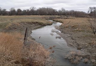
The Battle of Mud Springs took place February 4–6, 1865, in Nebraska between the U.S. army and warriors of the Lakota Sioux, Cheyenne, and Arapaho tribes. The battle was inconclusive, although the Indians succeeded in capturing some Army horses and a herd of several hundred cattle. Mud Springs is located 8 mi northwest of Dalton, Nebraska, and is today a National Historic Site.
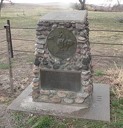
The Battle of Rush Creek took place February 8–9, 1865, between about 185 soldiers of the U.S. Army and 1,000 warriors of the Lakota Sioux, Cheyenne, and Arapaho tribes. The inconclusive battle took place 4 mi southeast of present-day Broadwater, Nebraska, along both banks of the North Platte River.

This is a list of the National Register of Historic Places listings in Morrill County, Nebraska.
The Battle of Platte Bridge, also called the Battle of Platte Bridge Station, on July 26, 1865 was the culmination of a summer offensive by the Lakota Sioux and Cheyenne Indians against the United States army. In May and June the Indians raided army outposts and stagecoach stations over a wide swath of Wyoming and Montana. In July, they assembled a large army, estimated by Cheyenne warrior George Bent to number 3,000 warriors, and descended upon Platte Bridge. The bridge, across the North Platte River near present-day Casper, Wyoming, was guarded by 120 soldiers. In an engagement near the bridge, and another against a wagon train guarded by 28 soldiers a few miles away, the Indians killed 29 soldiers while suffering at least eight dead.

South Platte Trail was a historic trail that followed the southern side of South Platte River from Fort Kearny in Nebraska to Denver, Colorado. Plains Indians, such as the Cheyenne and the Arapaho, hunted in the lands around the South Platte River. They also traded at trading posts along the route, as did white travelers. Travelers included trappers, traders, explorers, the military, and those following the gold rush. The trail was also used by the Pony Express.

Deadwood Draw is part of the Sidney-Black Hills Trail near Sidney, Nebraska, which provided supplies for gold mining operations in the Black Hills from 1874 to 1881. The draw served as a staging area for freight wagons carrying supplies to the Black Hills and contains ruts caused by the wheels of the freight wagons and the animals that pulled them. The draw is listed on the National Register of Historic Places.

O'Fallons Bluff is a section of bluffs about 20 miles (32 km) long that run along the south side of the Platte river near Sutherland in Lincoln County, Nebraska. The Oregon and California trails ran up and over these bluffs. They were characterized by American pioneers heading west to Oregon and California as sparse in vegetation with a number of violent incidents involving Native Americans. In the early 1860s, a Pony Express station was located about 5 miles (8 km) west of where the wagon trails went up the bluff. During construction of Interstate 80, the steep part of the bluffs were cut away but wagon ruts remained, which are marked by iron hoops signifying wagon wheels. It was listed in the National Register of Historic Places in 1974.

Fort Wicked was a ranch and stage station on the Overland Trail from 1864 to 1868 in present-day Merino, Colorado. A historical marker commemorating the ranch is located at US 6 and CR-2.5. The ranch itself was located near a ford of the South Platte River, near where US-6 now crosses over the river. It was one of the few places along the trail to Denver that withstood an attack by Native Americans in 1864. It was named Fort Wicked for the "bitter defence" made by Holon Godfrey.