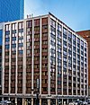
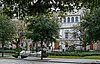
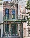
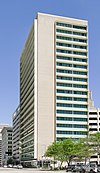
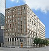
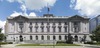
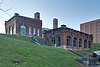
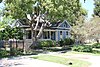
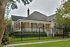
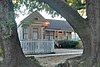
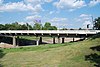
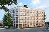
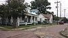
[3] Name on the Register Image Date listed [4] Location City or town Description 1 1879 Houston Waterworks 1879 Houston Waterworks May 6, 1976 (# 76002037 27 Artesian Place 29°45′50″N 95°22′10″W / 29.763889°N 95.369444°W / 29.763889; -95.369444 (1879 Houston Waterworks ) Houston 2 Almeda Road Bridge over Brays Bayou Almeda Road Bridge over Brays Bayou November 29, 2007 (# 07001234 Almeda Rd. at Brays Bayou 29°42′47″N 95°22′55″W / 29.713194°N 95.382083°W / 29.713194; -95.382083 (Almeda Road Bridge over Brays Bayou ) Houston 3 The Astrodome The Astrodome January 15, 2014 (# 13001099 8400 Kirby Drive 29°41′06″N 95°24′28″W / 29.685°N 95.407778°W / 29.685; -95.407778 (The Astrodome ) Houston 4 James L. Autry House James L. Autry House June 14, 1979 (# 79002953 5 Courtlandt Pl. 29°44′36″N 95°22′57″W / 29.743231°N 95.382624°W / 29.743231; -95.382624 (James L. Autry House ) Houston 5 Aviary at the Houston Zoo Aviary at the Houston Zoo August 9, 2005 (# 05000858 1513 N. McGregor 29°42′59″N 95°23′27″W / 29.71640°N 95.39090°W / 29.71640; -95.39090 (Aviary at the Houston Zoo ) Houston 6 Bayou Bend Bayou Bend December 6, 1979 (# 79002954 1 Westcott St. 29°45′27″N 95°25′14″W / 29.7575°N 95.420556°W / 29.7575; -95.420556 (Bayou Bend ) Houston 7 Benjamin Apartments Benjamin Apartments September 26, 2002 (# 02001063 1218 Webster St. 29°44′47″N 95°22′11″W / 29.746389°N 95.369722°W / 29.746389; -95.369722 (Benjamin Apartments ) Houston 8 Bethel Baptist Church Bethel Baptist Church January 16, 1998 (# 97001626 801 Andrews 29°45′04″N 95°22′33″W / 29.751111°N 95.375833°W / 29.751111; -95.375833 (Bethel Baptist Church ) Houston 9 Boulevard Oaks Historic District Boulevard Oaks Historic District February 22, 2002 (# 02000117 Roughly bounded by North Blvd., South Blvd., Hazard and Mandell Sts. 29°43′37″N 95°24′13″W / 29.726944°N 95.403611°W / 29.726944; -95.403611 (Boulevard Oaks Historic District ) Houston 10 Broadacres Historic District Broadacres Historic District April 16, 1980 (# 80004128 1300-1506 North Blvd. and 1305-1515 South Blvd. 29°43′37″N 95°23′48″W / 29.726944°N 95.396667°W / 29.726944; -95.396667 (Broadacres Historic District ) Houston 11 Cameron Iron Works Cameron Iron Works February 7, 2020 (# 100004967 711 Milby St. 29°44′42″N 95°20′22″W / 29.7449°N 95.3395°W / 29.7449; -95.3395 (Cameron Iron Works ) Houston 12 J. J. Carroll House Upload image June 14, 1979 (# 79002955 16 Courtlandt Pl. 29°44′38″N 95°23′04″W / 29.743872°N 95.384427°W / 29.743872; -95.384427 (J. J. Carroll House ) Houston 13 W. T. Carter Jr. House Upload image June 14, 1979 (# 79002956 18 Courtlandt Pl. 29°44′38″N 95°23′05″W / 29.743860°N 95.384803°W / 29.743860; -95.384803 (W. T. Carter Jr. House ) Houston 14 Cheek-Neal Coffee Company Building Cheek-Neal Coffee Company Building June 7, 2016 (# 16000350 2017 Preston 29°45′22″N 95°21′07″W / 29.756170°N 95.351872°W / 29.756170; -95.351872 (Cheek-Neal Coffee Company Building ) Houston [8] 15 Clarke & Courts Building Clarke & Courts Building April 14, 1994 (# 94000354 1210 W. Clay Ave. 29°45′20″N 95°23′38″W / 29.755556°N 95.393889°W / 29.755556; -95.393889 (Clarke & Courts Building ) Houston 16 William L. Clayton Summer House William L. Clayton Summer House February 2, 1984 (# 84001756 3376 Inwood Dr. 29°46′44″N 95°25′46″W / 29.778889°N 95.429444°W / 29.778889; -95.429444 (William L. Clayton Summer House ) Houston 17 A. S. Cleveland House Upload image June 14, 1979 (# 79002958 8 Courtlandt Pl. 29°44′38″N 95°23′00″W / 29.743906°N 95.383217°W / 29.743906; -95.383217 (A. S. Cleveland House ) Houston 18 Courtlandt Place Historic District Courtlandt Place Historic District December 3, 1980 (# 80004129 2-25 Courtlandt Pl. 29°44′37″N 95°23′03″W / 29.743527°N 95.384239°W / 29.743527; -95.384239 (Courtlandt Place Historic District ) Houston 19 James A. Dawson House Upload image March 17, 1994 (# 94000248 400 Emerson Ave. 29°44′29″N 95°23′01″W / 29.741380°N 95.383694°W / 29.741380; -95.383694 (James A. Dawson House ) Houston 20 DePelchin Faith Home DePelchin Faith Home August 9, 1984 (# 84001759 2700 Albany St. 29°44′57″N 95°22′58″W / 29.749204°N 95.382883°W / 29.749204; -95.382883 (DePelchin Faith Home ) Houston 21 Thomas J. Donoghue House Upload image June 14, 1979 (# 79002959 17 Courtlandt Pl. 29°44′36″N 95°23′05″W / 29.7432°N 95.3848°W / 29.7432; -95.3848 (Thomas J. Donoghue House ) Houston 22 John M. Dorrance House Upload image June 14, 1979 (# 79002960 9 Courtlandt Pl. 29°44′36″N 95°22′59″W / 29.7432°N 95.3831°W / 29.7432; -95.3831 (John M. Dorrance House ) Houston 23 Charles W., Sr. and Mary Duncan House Upload image July 24, 2017 (# 100001374 3664 Inverness Dr. 29°45′09″N 95°26′14″W / 29.7526°N 95.4372°W / 29.7526; -95.4372 (Charles W., Sr. and Mary Duncan House ) Houston 24 Eldorado Ballroom Upload image February 1, 2022 (# 100007402 2310 Elgin St. 29°44′05″N 95°21′55″W / 29.7346°N 95.3654°W / 29.7346; -95.3654 (Eldorado Ballroom ) Houston 25 Ned A. and Linda S. Eppes House Ned A. and Linda S. Eppes House December 30, 1997 (# 97001599 5322 Institute Ln. 29°43′29″N 95°23′50″W / 29.7247°N 95.3972°W / 29.7247; -95.3972 (Ned A. and Linda S. Eppes House ) Houston 26 Farnsworth & Chambers Building Farnsworth & Chambers Building October 29, 2009 (# 09000866 2999 S. Wayside 29°42′22″N 95°19′06″W / 29.7061°N 95.3184°W / 29.7061; -95.3184 (Farnsworth & Chambers Building ) Houston 27 Roy and Margaret Farrar House Upload image October 4, 2006 (# 06000923 511 Lovett Blvd. 29°44′35″N 95°23′16″W / 29.7431°N 95.3878°W / 29.7431; -95.3878 (Roy and Margaret Farrar House ) Houston 28 Fire Engine House No. 9 Upload image October 17, 1985 (# 85003238 1810-1812 Keene St. 29°46′31″N 95°21′05″W / 29.7753°N 95.3514°W / 29.7753; -95.3514 (Fire Engine House No. 9 ) Houston Demolished [9] 29 First Evangelical Church First Evangelical Church November 21, 2006 (# 06001066 1311 Holman St. 29°44′25″N 95°22′32″W / 29.7403°N 95.3756°W / 29.7403; -95.3756 (First Evangelical Church ) Houston 30 Maria Boswell Flake Home for Old Women Maria Boswell Flake Home for Old Women May 11, 2018 (# 100002435 1130 Berry St. 29°44′19″N 95°22′40″W / 29.7386°N 95.3779°W / 29.7386; -95.3779 (Maria Boswell Flake Home for Old Women ) Houston 31 J. A. Folger and Company Plant Upload image April 26, 2021 (# 100006493 235 North Norwood St. 29°44′48″N 95°18′56″W / 29.7468°N 95.3156°W / 29.7468; -95.3156 (J. A. Folger and Company Plant ) Houston 32 Forum of Civics Forum of Civics October 13, 1988 (# 88001053 2503 Westheimer Rd. 29°44′30″N 95°25′04″W / 29.7417°N 95.4178°W / 29.7417; -95.4178 (Forum of Civics ) Houston 33 Freedmen's Town Historic District Freedmen's Town Historic District January 17, 1985 (# 85000186 Roughly Bounded by Genesse, West Dallas, Arthur and W. Gray Sts. 29°45′19″N 95°22′49″W / 29.7553°N 95.3803°W / 29.7553; -95.3803 (Freedmen's Town Historic District ) Houston 34 Heights State Bank Building Heights State Bank Building June 22, 1983 (# 83004439 3620 Washington St. 29°46′11″N 95°23′48″W / 29.7697°N 95.3968°W / 29.7697; -95.3968 (Heights State Bank Building ) Houston 35 Hermann Park Municipal Golf Clubhouse Hermann Park Municipal Golf Clubhouse February 7, 2020 (# 100004968 6201 Hermann Park Dr. 29°42′51″N 95°23′20″W / 29.7143°N 95.3888°W / 29.7143; -95.3888 (Hermann Park Municipal Golf Clubhouse ) Houston 36 Fred J. Heyne House Fred J. Heyne House March 25, 1994 (# 94000266 220 Westmoreland Ave. 29°44′25″N 95°23′04″W / 29.7403°N 95.3844°W / 29.7403; -95.3844 (Fred J. Heyne House ) Houston 37 Hill Street Bridge over Buffalo Bayou Hill Street Bridge over Buffalo Bayou October 31, 2007 (# 07001131 S. Jensen Dr. at Buffalo Bayou 29°45′40″N 95°20′36″W / 29.7611°N 95.3433°W / 29.7611; -95.3433 (Hill Street Bridge over Buffalo Bayou ) Houston 38 Hollyfield Laundry and Cleaners Upload image February 28, 2017 (# 100006770 1731 Westheimer Rd. 29°44′34″N 95°24′13″W / 29.7427°N 95.4035°W / 29.7427; -95.4035 (Hollyfield Laundry and Cleaners ) Houston 39 Houston Fire Station No. 3 Houston Fire Station No. 3 February 28, 2017 (# 100000696 1919 Houston Ave. 29°46′30″N 95°22′22″W / 29.7751°N 95.3727°W / 29.7751; -95.3727 (Houston Fire Station No. 3 ) Houston 40 Houston Fire Station No. 7 Houston Fire Station No. 7 April 17, 1986 (# 86000798 2403 Milam St. 29°44′51″N 95°22′29″W / 29.7474°N 95.3748°W / 29.7474; -95.3748 (Houston Fire Station No. 7 ) Houston 41 Houston Light Guard Armory Houston Light Guard Armory January 4, 2024 (# 100009738 3820 Caroline Street 29°44′09″N 95°22′40″W / 29.7358°N 95.3779°W / 29.7358; -95.3779 (Houston Light Guard Armory ) Houston Home to the Buffalo Soldiers National Museum . 42 Houston Negro Hospital Houston Negro Hospital December 27, 1982 (# 82004856 3204 Ennis St. 29°43′52″N 95°21′37″W / 29.7311°N 95.3603°W / 29.7311; -95.3603 (Houston Negro Hospital ) Houston 43 Houston Negro Hospital School of Nursing Building Houston Negro Hospital School of Nursing Building December 27, 1982 (# 82004857 Holman Ave. and Ennis St. 29°43′34″N 95°21′26″W / 29.7261°N 95.3572°W / 29.7261; -95.3572 (Houston Negro Hospital School of Nursing Building ) Houston 44 Houston Post Upload image April 2, 2018 (# 100002269 2410 Polk St. 29°44′50″N 95°21′16″W / 29.7471°N 95.3544°W / 29.7471; -95.3544 (Houston Post ) Houston 45 Idylwood Historic District Upload image July 6, 2011 (# 11000425 Roughly bounded by Lawndale Ave., N. MacGregor Way, Sylvan Rd. & Wayside Dr. 29°43′15″N 95°18′36″W / 29.720833°N 95.31°W / 29.720833; -95.31 (Idylwood Historic District ) Houston 46 Isabella Court Isabella Court June 24, 1994 (# 94000628 3909-3917 S. Main St. 29°44′11″N 95°22′50″W / 29.736389°N 95.380556°W / 29.736389; -95.380556 (Isabella Court ) Houston 47 Jefferson Davis Hospital Jefferson Davis Hospital August 10, 2005 (# 05000859 1101 Elder 29°46′10″N 95°22′07″W / 29.769444°N 95.368611°W / 29.769444; -95.368611 (Jefferson Davis Hospital ) Houston 48 Morris and Mary Johnson House Upload image June 4, 1997 (# 97000541 3818 Spencer St. 29°46′30″N 95°23′58″W / 29.775°N 95.399444°W / 29.775; -95.399444 (Morris and Mary Johnson House ) Houston Demolished [10] 49 Jones-Hunt House Upload image June 14, 1979 (# 79002962 24 Courtlandt Pl. 29°44′38″N 95°23′09″W / 29.743842°N 95.385751°W / 29.743842; -95.385751 (Jones-Hunt House ) Houston 50 Lewis Apartment Building Lewis Apartment Building May 24, 1996 (# 96000587 2815-2817 Smith St. 29°44′43″N 95°22′44″W / 29.745278°N 95.378889°W / 29.745278; -95.378889 (Lewis Apartment Building ) Houston 51 Ewart H. and Lillian Lightfoot House Upload image February 2, 2024 (# 100009922 3702 Audubon Place 29°44′23″N 95°23′12″W / 29.7396°N 95.3866°W / 29.7396; -95.3866 (Ewart H. and Lillian Lightfoot House ) Houston 52 Link-Lee House Link-Lee House September 11, 2000 (# 00000751 3800 Montrose 29°44′16″N 95°23′29″W / 29.737778°N 95.391389°W / 29.737778; -95.391389 (Link-Lee House ) Houston 53 Logue House Logue House April 30, 1998 (# 98000428 1101 Milford 29°43′44″N 95°23′31″W / 29.728889°N 95.391944°W / 29.728889; -95.391944 (Logue House ) Houston 54 Leonard W. Macatee House Leonard W. Macatee House May 6, 2005 (# 05000387 1220 Southmore Blvd. 29°43′37″N 95°23′07″W / 29.726886°N 95.385284°W / 29.726886; -95.385284 (Leonard W. Macatee House ) Houston 55 Marguerite Meachum & John S. Mellinger House Upload image June 20, 2012 (# 12000351 3452 Del Monte Drive 29°45′04″N 95°25′58″W / 29.75111°N 95.43291°W / 29.75111; -95.43291 (Marguerite Meachum & John S. Mellinger House ) Houston 56 Mechanical Laboratory and Power House Mechanical Laboratory and Power House January 14, 2021 (# 100006045 6100 Main St. (Rice University ) 29°42′56″N 95°23′52″W / 29.7155°N 95.3978°W / 29.7155; -95.3978 (Mechanical Laboratory and Power House ) Houston 57 Medical Towers Medical Towers December 27, 2016 (# 16000918 1709 Dryden Rd. 29°42′35″N 95°24′05″W / 29.709787°N 95.401493°W / 29.709787; -95.401493 (Medical Towers ) Houston 58 James V. Meek House James V. Meek House March 17, 1994 (# 94000247 3704 Garrott Ave. 29°44′22″N 95°23′08″W / 29.739444°N 95.385556°W / 29.739444; -95.385556 (James V. Meek House ) Houston 59 Ezekial and Mary Jane Miller House Ezekial and Mary Jane Miller House October 6, 1983 (# 83003788 304 Hawthorne St. 29°44′36″N 95°23′02″W / 29.743333°N 95.383889°W / 29.743333; -95.383889 (Ezekial and Mary Jane Miller House ) Houston 60 Simon and Mamie Minchen House Simon and Mamie Minchen House December 7, 2000 (# 00001496 1753 North Blvd. 29°43′45″N 95°24′15″W / 29.729167°N 95.404167°W / 29.729167; -95.404167 (Simon and Mamie Minchen House ) Houston 61 Angelo and Lillian Minella House Angelo and Lillian Minella House September 13, 2006 (# 06000818 6328 Brookside Dr. 29°43′52″N 95°18′59″W / 29.731111°N 95.316389°W / 29.731111; -95.316389 (Angelo and Lillian Minella House ) Houston 62 Moncrief-Lenoir Manufacturing Company Upload image November 15, 2023 (# 100009405 2103 Lyons Ave. 29°46′18″N 95°20′52″W / 29.7717°N 95.3478°W / 29.7717; -95.3478 (Moncrief-Lenoir Manufacturing Company ) Houston 63 Sterling Myer House Upload image June 14, 1979 (# 79002964 4 Courtlandt Pl. 29°44′37″N 95°22′55″W / 29.743611°N 95.381944°W / 29.743611; -95.381944 (Sterling Myer House ) Houston 64 Myers-Spalti Manufacturing Plant Myers-Spalti Manufacturing Plant September 12, 2003 (# 03000936 2115 Runnels St. 29°45′45″N 95°20′49″W / 29.7625°N 95.346944°W / 29.7625; -95.346944 (Myers-Spalti Manufacturing Plant ) Houston 65 William R. Nash House William R. Nash House August 23, 1990 (# 90001293 215 Westmoreland Ave. 29°44′27″N 95°23′04″W / 29.740833°N 95.384444°W / 29.740833; -95.384444 (William R. Nash House ) Houston 66 Near North Side Historic District Upload image November 29, 2010 (# 10000960 Roughly bounded by Little White Oak Bayou on the N; Hogan on the S; I-45 on the W and the block between N Main and Keene 29°46′42″N 95°21′55″W / 29.778333°N 95.365278°W / 29.778333; -95.365278 (Near North Side Historic District ) Houston 67 C. L. Neuhaus House Upload image June 14, 1979 (# 79002965 6 Courtlandt Pl. 29°44′38″N 95°22′58″W / 29.743904°N 95.382815°W / 29.743904; -95.382815 (C. L. Neuhaus House ) Houston 68 Hugo V. Neuhaus Jr. House Upload image March 30, 2005 (# 05000246 2910 Lazy Ln. 29°45′23″N 95°25′01″W / 29.756369°N 95.416873°W / 29.756369; -95.416873 (Hugo V. Neuhaus Jr. House ) Houston 69 Old Sixth Ward Historic District Old Sixth Ward Historic District January 23, 1978 (# 78002946 Bounded by Washington, Union, Houston, Capitol and Glenwood Cemetery 29°45′57″N 95°22′38″W / 29.765833°N 95.377222°W / 29.765833; -95.377222 (Old Sixth Ward Historic District ) Houston 70 The Orange Show The Orange Show November 21, 2006 (# 06001063 2401 Munger St. 29°43′10″N 95°19′28″W / 29.719444°N 95.324444°W / 29.719444; -95.324444 (The Orange Show ) Houston 71 Edward Albert Palmer Memorial Chapel and Autry House Edward Albert Palmer Memorial Chapel and Autry House October 31, 1984 (# 84000388 6221 and 6265 Main St. 29°42′57″N 95°23′47″W / 29.715833°N 95.396389°W / 29.715833; -95.396389 (Edward Albert Palmer Memorial Chapel and Autry House ) Houston 72 John W. Parker House Upload image June 14, 1979 (# 79002966 2 Courtlandt Pl. 29°44′38″N 95°22′55″W / 29.743958°N 95.381990°W / 29.743958; -95.381990 (John W. Parker House ) Houston 73 D. D. Peden House Upload image July 16, 1991 (# 91000889 2 Longfellow Ln. 29°43′21″N 95°23′35″W / 29.722593°N 95.393002°W / 29.722593; -95.393002 (D. D. Peden House ) Houston 74 Rothko Chapel Rothko Chapel August 16, 2000 (# 00000883 1409 Sul Ross Ave. 29°44′15″N 95°23′46″W / 29.7375°N 95.396111°W / 29.7375; -95.396111 (Rothko Chapel ) Houston 75 Sabine Street Bridge over Buffalo Bayou Sabine Street Bridge over Buffalo Bayou September 28, 2007 (# 07001023 Sabine St. at Buffalo Bayou 29°45′45″N 95°22′31″W / 29.7625°N 95.375278°W / 29.7625; -95.375278 (Sabine Street Bridge over Buffalo Bayou ) Houston 76 St. Elizabeth's Hospital St. Elizabeth's Hospital March 6, 2019 (# 100003489 4514 Lyons Ave. 29°46′33″N 95°19′28″W / 29.775804°N 95.324338°W / 29.775804; -95.324338 (St. Elizabeth's Hospital ) Houston 77 St. Paul's Methodist Episcopal Church Upload image September 12, 2019 (# 100004373 5501 Main St. 29°43′33″N 95°23′19″W / 29.725904°N 95.388708°W / 29.725904; -95.388708 (St. Paul's Methodist Episcopal Church ) Houston 78 San Felipe Courts Historic District San Felipe Courts Historic District February 16, 1988 (# 88000042 1 Allen Pkwy. Village 29°45′34″N 95°22′42″W / 29.759444°N 95.378333°W / 29.759444; -95.378333 (San Felipe Courts Historic District ) Houston 79 San Jacinto Senior High School San Jacinto Senior High School December 5, 2012 (# 12001000 Houston Community College Central 29°44′15″N 95°22′36″W / 29.7374°N 95.37654°W / 29.7374; -95.37654 (San Jacinto Senior High School ) Houston Consists of three contributing buildings [11] 80 Schlumberger Well Surveying Corporation Building Schlumberger Well Surveying Corporation Building June 24, 2018 (# 10002601 2720 Leeland Street 29°44′35″N 95°21′12″W / 29.743175°N 95.353444°W / 29.743175; -95.353444 (Schlumberger Well Surveying Corporation Building ) Houston 81 Sears, Roebuck and Company Warehouse and Service Center Sears, Roebuck and Company Warehouse and Service Center June 25, 2020 (# 100005314 5901 Griggs Rd. 29°41′56″N 95°19′31″W / 29.698792°N 95.325375°W / 29.698792; -95.325375 (Sears, Roebuck and Company Warehouse and Service Center ) Houston 82 Sessums-James House Upload image November 19, 1998 (# 98001344 3802 Spencer 29°46′30″N 95°23′57″W / 29.775°N 95.399167°W / 29.775; -95.399167 (Sessums-James House ) Houston Demolished [12] 83 Cleveland Harding Sewall House Cleveland Harding Sewall House April 14, 1975 (# 75001991 3452 Inwood St. 29°45′07″N 95°25′48″W / 29.751944°N 95.43°W / 29.751944; -95.43 (Cleveland Harding Sewall House ) Houston 84 Sheridan Apartments Sheridan Apartments August 2, 1984 (# 84001825 802-804 McGowen St. 29°44′45″N 95°22′32″W / 29.745833°N 95.375556°W / 29.745833; -95.375556 (Sheridan Apartments ) Houston 85 Sills Building Upload image March 5, 2024 (# 100010026 5804 Canal Street 29°44′40″N 95°18′57″W / 29.7445°N 95.3158°W / 29.7445; -95.3158 (Sills Building ) Houston 86 Star Engraving Company Building Star Engraving Company Building January 6, 1995 (# 94001521 3201 Allen Pkwy. 29°45′36″N 95°23′19″W / 29.76°N 95.388611°W / 29.76; -95.388611 (Star Engraving Company Building ) Houston
87 Sterling-Berry House Upload image July 14, 1983 (# 83004479 4515 Yoakum Blvd. 29°43′56″N 95°23′32″W / 29.732248°N 95.392118°W / 29.732248; -95.392118 (Sterling-Berry House ) Houston 88 Joseph R. and Mary M. Stevenson House Joseph R. and Mary M. Stevenson House March 21, 1996 (# 96000275 804 Harold St. 29°44′28″N 95°23′20″W / 29.741111°N 95.388889°W / 29.741111; -95.388889 (Joseph R. and Mary M. Stevenson House ) Houston 89 Judson L. Taylor House Upload image June 14, 1979 (# 79002968 20 Courtlandt Pl. 29°44′38″N 95°23′06″W / 29.743876°N 95.385120°W / 29.743876; -95.385120 (Judson L. Taylor House ) Houston Colonial Revival house designed by Birdsall Briscoe 90 Telephone Road Bridge over Brays Bayou Telephone Road Bridge over Brays Bayou November 29, 2007 (# 07001235 Telephone Rd. at Brays Bayou 29°42′37″N 95°18′48″W / 29.710278°N 95.313333°W / 29.710278; -95.313333 (Telephone Road Bridge over Brays Bayou ) Houston 91 Temple Beth Israel Temple Beth Israel March 1, 1984 (# 84001826 3517 Austin St. 29°44′12″N 95°22′30″W / 29.736667°N 95.375°W / 29.736667; -95.375 (Temple Beth Israel ) Houston 92 Lucie Wray and Anderson Todd House Upload image August 31, 2018 (# 100002842 9 Shadowlawn Cir. 29°43′28″N 95°23′42″W / 29.7245°N 95.3950°W / 29.7245; -95.3950 (Lucie Wray and Anderson Todd House ) Houston 93 Trinity Church Trinity Church May 26, 1983 (# 83004481 3404 S. Main St. 29°44′22″N 95°22′39″W / 29.739444°N 95.3775°W / 29.739444; -95.3775 (Trinity Church ) Houston 94 Union Transfer and Storage Building Union Transfer and Storage Building January 16, 2001 (# 00001665 1113 Vine St. 29°46′12″N 95°21′25″W / 29.77°N 95.356944°W / 29.77; -95.356944 (Union Transfer and Storage Building ) Houston 95 W-K-M Company, Inc. Historic District Upload image June 25, 2018 (# 100002602 Roughly bounded by Commerce, Sampson, Preston & Velasco Streets 29°45′03″N 95°20′27″W / 29.750724°N 95.340707°W / 29.750724; -95.340707 (W-K-M Company, Inc. Historic District ) Houston 96 West Eleventh Place Historic District West Eleventh Place Historic District April 14, 1997 (# 97000317 1-8 W. 11th Pl. 29°43′31″N 95°23′31″W / 29.725278°N 95.391944°W / 29.725278; -95.391944 (West Eleventh Place Historic District ) Houston 97 Westmoreland Historic District Westmoreland Historic District August 16, 1994 (# 94000859 Bounded by Hawthorne, Burlington and Marshall Aves., and Garott St. 29°44′26″N 95°23′00″W / 29.740556°N 95.383333°W / 29.740556; -95.383333 (Westmoreland Historic District ) Houston 98 Andrew Jackson and Margaret Cullinan Wray House Andrew Jackson and Margaret Cullinan Wray House August 19, 1993 (# 93000844 3 Remington Ln. 29°43′25″N 95°23′35″W / 29.723603°N 95.393163°W / 29.723603; -95.393163 (Andrew Jackson and Margaret Cullinan Wray House ) Houston