
Dealey Plaza is a city park in the West End district of downtown Dallas, Texas. It is sometimes called the "birthplace of Dallas". It also was the location of the assassination of United States President John F. Kennedy, on November 22, 1963; 30 minutes after the shooting, Kennedy died at Parkland Memorial Hospital. The Dealey Plaza Historic District was named a National Historic Landmark on November 22, 1993, the 30th anniversary of the JFK assassination, to preserve Dealey Plaza, street rights-of-way, and buildings and structures by the plaza visible from the assassination site, that have been identified as witness locations or as possible locations for assassin(s).

Downtown is the largest business district in Houston, Texas, located near the geographic center of the metropolitan area at the confluence of Interstate 10, Interstate 45, and Interstate 69. The 1.84-square-mile (4.8 km2) district, enclosed by the aforementioned highways, contains the original townsite of Houston at the confluence of Buffalo Bayou and White Oak Bayou, a point known as Allen's Landing. Downtown has been the city's preeminent commercial district since its founding in 1836.

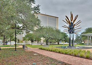
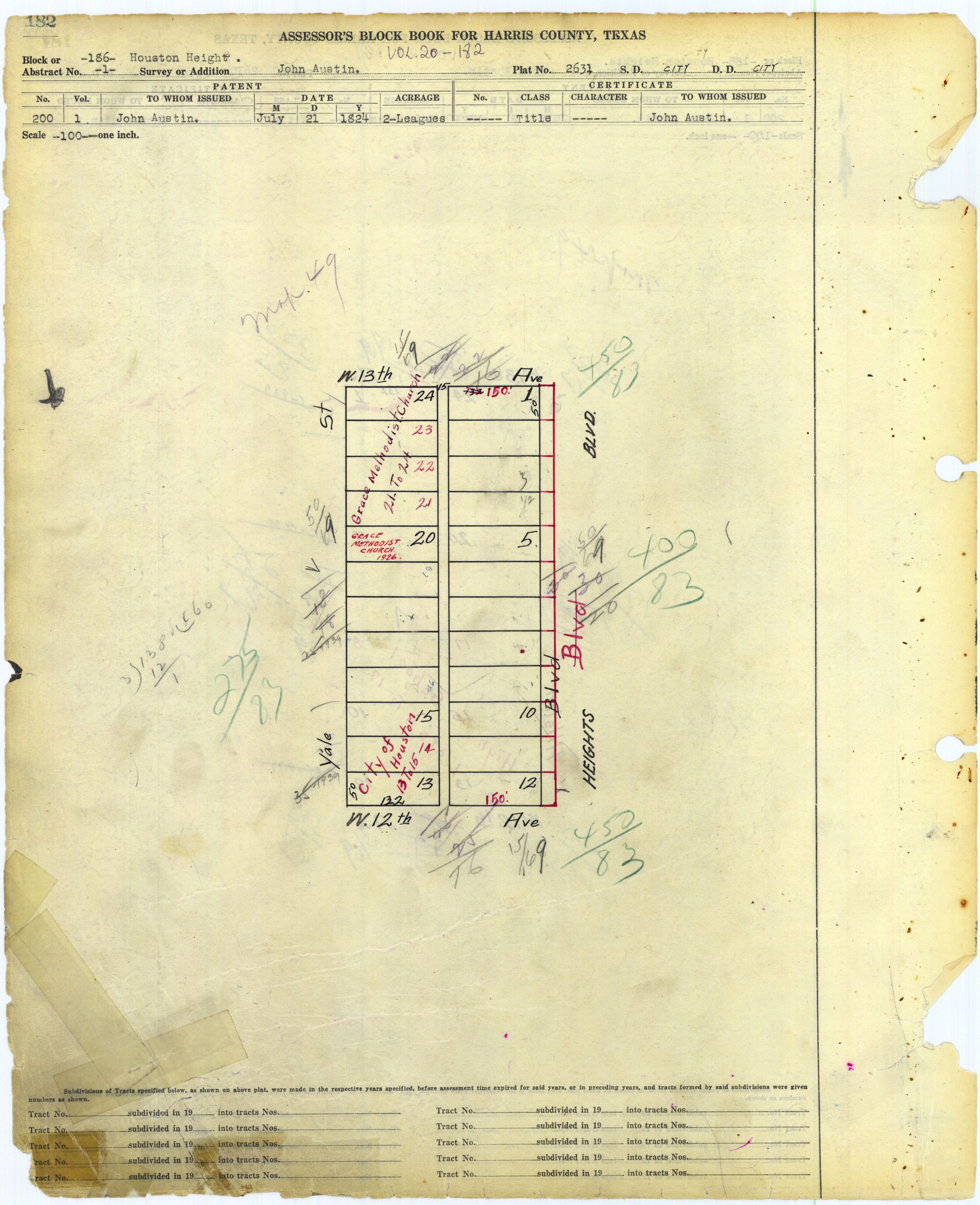
Houston Heights is a community in northwest-central Houston, Texas, United States. "The Heights" is often referred to colloquially to describe a larger collection of neighborhoods next to and including the actual Houston Heights. However, Houston Heights has its own history, distinct from Norhill and Woodland Heights.

Braeswood Place is a group of subdivisions in Harris County, Texas, United States. The vast majority of the land is in Houston while a small part is in Southside Place.

This is a list of the National Register of Historic Places listings in Houghton County, Michigan.
Independence Heights is a community in Houston, Texas, bordered by 40th Street east of N. Main and 40th Street west of N. Main to the north, Yale Street to the west, the 610 Loop to the south, and Airline Drive to the east. The Super Neighborhood boundary created by the City of Houston is bordered by Tidwell to the north, Shepherd Drive to the west, the 610 Loop to the south, and Interstate 45 to the east.

This is a list of the National Register of Historic Places in Harris County, Texas. It is intended to be a complete list of properties and districts listed on the National Register of Historic Places in Harris County, Texas, United States.
Main Street Market Square Historic District is a historic district in Houston that includes the Market Square Park. It includes buildings nearby, as well as the square itself. It was listed on the National Register of Historic Places in 1983.

All Saints Catholic Church is an historic church at 201 East 10th Street in the historic Heights area of Houston, Texas. The parish is a part of the Archdiocese of Galveston-Houston. It is in Houston Heights block 218.

The Barker House or David Barker House is a historic house located in Houston, Texas It was listed on the National Register of Historic Places on 14 May 1984 and designated a Recorded Texas Historic Landmark in 1990.

Union Station is a building in Houston, Texas, in the United States. Dedicated on March 2, 1911, and formerly a hub of rail transportation, the building now serves as a cornerstone for Minute Maid Park. It is listed on the National Register of Historic Places, and has since been superseded by Houston's Amtrak station.

The Sweeney, Coombs, and Fredericks Building is a late Victorian commercial building with a 3-story corner turret and Eastlake decorative elements that was designed by George E. Dickey in 1889. The building is located at 301 Main Street in Houston, Texas and occupies the corner of Main Street and Congress Street in Downtown Houston. The building is one of the few Victorian-style architectural structures that remains in the city. The building received a "City of Houston Landmark" designation in 2009. The building is included in the National Register of Historic Places by virtue of being a conforming structure in the Main Street/Market Square Historic District.

Jefferson Davis Hospital operated from 1924 to 1938 and was the first centralized municipal hospital to treat indigent patients in Houston, Texas. It is listed in the National Register of Historic Places. The building, located in Houston's Historic First Ward, was designated as a protected historic landmark on November 13, 2013, by the Houston City Council and is monitored by the Historic Preservation Office of the City of Houston Department of Planning and Development. The property has been reoccupied by ArtSpace as the Elder Street Artists Lofts since 2005, which provides 24 live/work units for local artists to rent.

Houston Fire Station No. 7 is a historic fire station located at 2403 Milam Street in Houston, Texas. It was listed on the National Register of Historic Places on April 17, 1986. The fire station was built in 1898 and opened the next year as the first paid station in Houston. It was active until a replacement was built 1969. The building has been used as the Houston Fire Museum after a renovation, started in 1980.

The City National Bank Building, located at 1001 McKinney Avenue in Houston, Texas, was listed on the National Register of Historic Places on April 3, 2000.

The Morton Brothers Grocery, located at 401 West Ninth in Houston, Texas, is a historic building located in the Houston Heights neighborhood. Built in 1929, it was a neighborhood grocery store run by Curtiss I. Morton and his brother, William J. Morton until 1949. It is a one-story brick veneer commercial building, one of the few such remaining in the Heights. Its most recent use has been as a private home. It was listed on the National Register of Historic Places on January 15, 1988.

The Schauer Filling Station, formerly located at 1400 Oxford Street, was one of the first gas stations in Houston, in the U.S. state of Texas. The station was completed in 1929, and listed on the National Register of Historic Places. The structure was demolished in June 2013 and delisted on June 14, 2017.
This is a list of the National Register of Historic Places in outer Harris County, Texas. It is intended to be a complete list of properties and districts listed on the National Register of Historic Places in outer portion of Harris County, Texas, United States, defined as outside the I-610 loop. The locations of National Register properties and districts may be seen in a map by clicking on "Map of all coordinates."
This is a list of the National Register of Historic Places in inner Harris County, Texas, defined as within the I-610 loop within Harris County, Texas, but excluding those places in Downtown Houston and those in Houston Heights, which are listed separately.

Heights Neighborhood Library is a public library facility in the Houston Heights area of Houston, Texas. It is a part of Houston Public Library (HPL) and is located at 1302 Heights Boulevard, in Heights block 170. It has a pink Stucco Italian Renaissance façade and arches in its doors and windows. Jason P. Theriot wrote in the Houston Review that the ceilings are "high" and that the arches were "beautifully" done. The library has 14,500 square feet (1,350 m2) of space.


