
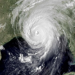
Hurricane Betsy was an intense, deadly and destructive tropical cyclone that brought widespread damage to areas of Florida and the central United States Gulf Coast in September 1965. The storm's erratic nature, coupled with its intensity and minimized preparation time contributed to making Betsy the first tropical cyclone in the Atlantic basin to accrue at least $1 billion in damage. While the storm primarily affected areas of southern Florida and Louisiana, lesser effects were felt in the Bahamas and as far inland in the United States as the Ohio River Valley. Betsy began as a tropical depression north of French Guiana on August 27, and strengthened as it moved in a general northwesterly direction. After executing a slight anticyclonic loop north of the Bahamas, Betsy proceeded to move through areas of south Florida on September 8, causing extensive crop damage. After emerging into the Gulf of Mexico, the cyclone strengthened and reached its peak intensity equivalent to that of a Category 4 hurricane on September 10 before making its final landfall near Grand Isle, Louisiana, shortly thereafter. Once inland, Betsy was slow to weaken, and persisted for two more days before degenerating into an extratropical storm; these remnants lasted until September 13.

Tropical cyclone warnings and watches are alerts issued by national weather forecasting bodies to coastal areas threatened by the imminent approach of a tropical cyclone of tropical storm or hurricane intensity. They are notices to the local population and civil authorities to make appropriate preparation for the cyclone, including evacuation of vulnerable areas where necessary. It is important that interests throughout the area of an alert make preparations to protect life and property, and do not disregard it on the strength of the detailed forecast track.

Hurricane Katrina was a devastating and deadly tropical cyclone that caused 1,392 fatalities and damages estimated at $186.3 billion in late August 2005, particularly in the city of New Orleans and its surrounding area. Katrina was the twelfth tropical cyclone, the fifth hurricane, and the third major hurricane of the 2005 Atlantic hurricane season. It was also the fourth-most intense Atlantic hurricane to make landfall in the contiguous United States, gauged by barometric pressure.
Hurricane Katrina's winds and storm surge reached the Mississippi coastline on the morning of August 29, 2005. beginning a two-day path of destruction through central Mississippi; by 10 a.m. CDT on August 29, 2005, the eye of Katrina began traveling up the entire state, only slowing from hurricane-force winds at Meridian near 7 p.m. and entering Tennessee as a tropical storm. Many coastal towns of Mississippi had already been obliterated, in a single night. Hurricane-force winds reached coastal Mississippi by 2 a.m. and lasted over 17 hours, spawning 11 tornadoes and a 28-foot (8.5 m) storm surge flooding 6–12 miles (9.7–19.3 km) inland. Many, unable to evacuate, survived by climbing to attics or rooftops, or swimming to higher buildings and trees. The worst property damage from Katrina occurred in coastal Mississippi, where all towns flooded over 90% in hours, and waves destroyed many historic buildings, with others gutted to the 3rd story. Afterward, 238 people died in Mississippi, and all counties in Mississippi were declared disaster areas, 49 for full federal assistance. Regulations were changed later for emergency centers and casinos. The emergency command centers were moved higher because all 3 coastal centers flooded at 30 ft (9.1 m) above sea level. Casinos were allowed on land rather than limited to floating casino barges as in 2005.
This article contains a historical timeline of the events of Hurricane Katrina on August 23–30, 2005 and its aftermath.

The 2005 Atlantic hurricane season was an event in the annual tropical cyclone season in the north Atlantic Ocean. It was the second most active Atlantic hurricane season in recorded history, and the most extreme in the satellite era. Officially, the season began on June 1, 2005 and ended on November 30, 2005. These dates, adopted by convention, historically delimit the period in each year when most tropical systems form. The season's first storm, Tropical Storm Arlene, developed on June 8. The final storm, Tropical Storm Zeta, formed in late December and persisted until January 6, 2006. Zeta is only the second December Atlantic storm in recorded history to survive into January, joining Hurricane Alice in 1955.
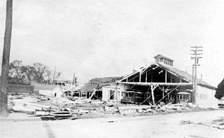
The New Orleans Hurricane of 1915 was an intense Category 4 hurricane that made landfall near Grand Isle, Louisiana, and the most intense tropical cyclone during the 1915 Atlantic hurricane season. The storm formed in late September when it moved westward and peaked in intensity of 145 mph (233 km/h) to weaken slightly by time of landfall on September 29 with recorded wind speeds of 126 mph (203 km/h) as a strong category 3 Hurricane. The hurricane killed 275 people and caused $13 million in damage.
This article covers the details of the preparations for Hurricane Katrina, a major Category 5 Atlantic hurricane that devastated parts of New Orleans, Florida, Louisiana, Mississippi, and Alabama, as well as the Hurricane Pam simulation and NWS forecasts that led to the U.S. government's decision to establish a Bipartisan Congressional Committee to investigate the country's preparedness for and response to Hurricane Katrina.

A flash flood warning is a severe weather warning product of the National Weather Service that is issued by national weather forecasting agencies throughout the world to alert the public that a flash flood is imminent or occurring in the warned area. A flash flood is a sudden, violent flood after a heavy rain, or occasionally after a dam break. Rainfall intensity and duration, topography, soil conditions, and ground cover contribute to flash flooding.

Tropical Storm Dean was a short-lived storm that formed in late July 1995 and lasted into early August. It was the fourth named storm of the 1995 Atlantic hurricane season. It spent most of its life as a tropical depression, and briefly gained tropical storm status before its landfall on the Texas coast on July 30. After landfall, it dissipated over central Texas on August 2. The impacts from Dean were minimal, mainly due to heavy rain in Oklahoma and Texas that caused localized coastal and inland flooding. Two F0 Tornadoes touched down in Texas as a result of Dean's landfall. Also, Twenty families had to be evacuated in Chambers County, due to flooding in the area. One fatality was recorded as a result of flooding in Oklahoma. Several highways were flooded out in Oklahoma, which impeded travel in the state. In addition approximately $500,000 worth of damage was recorded in the aftermath of Dean.

An extreme wind warning is an alert issued by the National Weather Service for areas that will experience sustained surface winds 100 knots or greater within one hour, due to a landfalling tropical cyclone. Extreme wind warnings are intended to provide guidance to the general public at a county or sub-county level when such winds pose a significant threat of casualties. Their issuance is intended to cover as precise of an area as possible and can be issued no earlier than two hours before the onset of extreme winds. The extreme wind warning should not be confused with tornado warnings, which covers rotating supercells from severe storms, and high wind warnings, which is similar, but used for non-severe/tornadic winds of 40 mph to 114 mph, mainly on land.

Hurricane Gustav was the second most destructive hurricane of the 2008 Atlantic hurricane season. The seventh tropical cyclone, third hurricane, and second major hurricane of the season, Gustav caused serious damage and casualties in Haiti, the Dominican Republic, Jamaica, the Cayman Islands, Cuba and the United States. Gustav caused at least $8.31 billion (2008 USD) in damages.
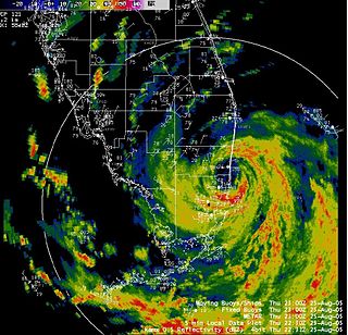
The effects of Hurricane Katrina in Florida were in both the southern portion of the state and in the panhandle. After developing on August 23, Katrina made landfall near the border of Broward and Miami-Dade counties with 80 mph (130 km/h) winds on August 25. While it was crossing the state, the hurricane's convection was asymmetrical, primarily located to the south and east of the center. As a result, high rainfall totals occurred in the Miami area, peaking at 16.43 in (417 mm) in Perrine. The rains caused flooding, and the combination of rains and winds downed trees and power lines, leaving 1.45 million people without power. Damage in South Florida was estimated at $523 million (2005 USD), mostly as a result of crop damage. Further south, the hurricane spawned a tornado in the Florida Keys. In the island chain, Katrina caused heavy rainfall and gusty winds.

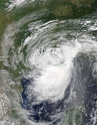
The 1926 Louisiana hurricane caused widespread devastation to the United States Gulf Coast, particularly in Louisiana. The third tropical cyclone and hurricane of the 1926 Atlantic hurricane season, it formed from a broad area of low pressure in the central Caribbean Sea on August 20. Moving to the northwest, the storm slowly intensified, reaching tropical storm strength on August 21 and subsequently attaining hurricane strength after passing through the Yucatán Channel. The hurricane steadily intensified as it recurved northwards in the Gulf of Mexico, before reaching peak intensity just prior to landfall near Houma, Louisiana on August 25 with winds of 115 mph (185 km/h). After moving inland, the tropical cyclone moved to the west and quickly weakened, before dissipating on August 27.
A hurricane local statement (HLS) is a weather statement produced for the public by the local Weather Forecast Offices of the National Weather Service in the U.S. for areas affected or forecast to be affected by a tropical storm or hurricane that provides an overview of the storm's local effects, including expected weather conditions, evacuation decisions made by local officials, and precautions necessary to protect life and property. The National Weather Services considers the HLS to be the "flagship product" available to Weather Forecast Offices for outlining tropical cyclone watches and warnings and impacts, and is their most visible product during such events. Descriptions of the affected areas, relevant tropical cyclone watches and warnings, recommendations for precautionary measures, and expected timing and severity of possible threats are typically included in an HLS. The HLS can incorporate projected impacts from pre-written descriptions tailored for different storm intensities; these template descriptions were developed in the 1990s and became widely available to forecasters for use in the HLS by 2001. The bulletin issued by the Weather Forecast Office in Slidell, Louisiana, as Hurricane Katrina approached on August 28, 2005, known as "The Bulletin", was lauded by the National Weather Service as having further encouraged vulnerable individuals to evacuate. Not all forecast offices can issue an HLS.
Robert Ricks Jr. is a retired American meteorologist who worked as a lead forecaster at the National Weather Service (NWS) in Slidell, Louisiana. He is known for the strongly worded bulletin he wrote prior to the arrival of Hurricane Katrina, which vividly warned of the damage that the storm would cause. A later review by the NWS called attention to the "unprecedented detail and foreboding nature" of the forecast, and credited it with helping assist officials as they evacuated residents in the storm's path.
Hurricane Barry was an asymmetrical Category 1 hurricane that was the wettest tropical cyclone on record in Arkansas and the fourth-wettest in Louisiana. The second tropical or subtropical storm and first hurricane of the 2019 Atlantic hurricane season, Barry originated as a mesoscale convective vortex over southwestern Kansas on July 2. The system eventually emerged into the Gulf of Mexico from the Florida Panhandle on July 10, whereupon the National Hurricane Center (NHC) designated it as a potential tropical cyclone. Early on July 11, the system developed into a tropical depression, and strengthened into a tropical storm later that day. Dry air and wind shear caused most of the convection, or thunderstorms, to be displaced south of the center. Nevertheless, Barry gradually intensified. On July 13, Barry attained its peak intensity as Category 1 hurricane with 1-minute sustained winds of 75 mph (120 km/h) and a minimum central pressure of 993 millibars (29.3 inHg). At 15:00 UTC, Barry made its first landfall at Marsh Island, and another landfall in Intracoastal City, Louisiana, both times as a Category 1 hurricane. Barry quickly weakened after landfall, falling to tropical depression status on July 15. The storm finally degenerated into a remnant low over northern Arkansas on the same day, subsequently opening up into a trough on July 16. The storm's remnants persisted for another few days, while continuing its eastward motion, before being absorbed into another frontal storm to the south of Nova Scotia on July 19.

The effects of Hurricane Katrina in Alabama were damaging and deadly. On August 29, Hurricane Katrina made two landfalls in Louisiana and Mississippi. Katrina caused many impacts due to its large wind field across the southeast, including places like Alabama.

A tornado outbreak spawned by Hurricane Beryl and its remnants impacted the South Central United States, Mississippi Valley, and Northeastern United States between July 8–10, 2024. Hurricane Beryl, which was the first major hurricane of the 2024 Atlantic hurricane season, made landfall in Texas as a Category 1 hurricane, and moved inland over the Southern United States, spawning numerous tornadoes across the states of Texas, Louisiana, and Arkansas on July 8. 110 tornado warnings were issued on July 8 alone, the most for any day in July. The outbreak also set new records for tornado warning issuances in a single day for the National Weather Service Offices in Shreveport and Buffalo, New York, at 67 and 9 respectively. With 67 recorded tornadoes, this was the most prolific tropical cyclone-related tornado outbreak in the United States since Hurricane Rita in 2005.
