{{Use dmy https://en.m.wikipedia.org/w/index.php?title=New_Port%2C_South_Australia&action=edit§ion=0 2014}}
New Port Adelaide, South Australia | |||||||||||||||
---|---|---|---|---|---|---|---|---|---|---|---|---|---|---|---|
Coordinates | 34°50′43″S138°29′37″E / 34.845275°S 138.493515°E [1] | ||||||||||||||
Population | 647 (SAL 2021) [2] | ||||||||||||||
Established | 12 July 2007 [3] | ||||||||||||||
Postcode(s) | 5015 [1] | ||||||||||||||
Time zone | ACST (UTC+9:30) | ||||||||||||||
• Summer (DST) | ACST (UTC+10:30) | ||||||||||||||
LGA(s) | City of Port Adelaide Enfield | ||||||||||||||
Region | Western Adelaide [1] | ||||||||||||||
County | Adelaide [1] | ||||||||||||||
State electorate(s) | Port Adelaide [4] | ||||||||||||||
Federal division(s) | Hindmarsh [5] | ||||||||||||||
| |||||||||||||||
| |||||||||||||||
Footnotes | LGA [1] Adjoining suburbs [1] |
New Port is a north-western suburb of Adelaide, South Australia. It is located in the City of Port Adelaide Enfield. [1] Australian
In 2004, Premier of South Australia Mike Rann, announced the commencement of a major redevelopment of the Port Adelaide waterfront. With an estimated budget of $1.2 billion, the Newport Quays development was to include 2000 homes across six different precincts. At completion, the development was proposed to also include cafes, museums, public parks and various commercial properties. [7] In 2007, the suburb of New Port was created from parts of the suburbs of Birkenhead, Ethelton, Glanville and Semaphore Park. [3] The name "Newport Quays" had been requested but this was not supported by the relevant government authority. [8] On 6 August 2009, the eastern boundary of the suburb was extended in part to the centre-line of the Port River. [9]
By 2007, stage one of Newport Quays was complete, with stage two construction well underway. Ambitious new plans for stage three of the development were revealed in September 2007, including an apartment building constructed over the Port River. [10] However, these plans never eventuated, and the New Port Quays development had ultimately been stalled.
Newport Quays received a lot of criticism from the local community for being unsympathetic to the local area and destroying local heritage. [11] A state government established committee found many issues with plans for development stage 2B, including lack of open space, and exceeding of permitted building heights. [11] [12] In 2008, residents in New Port raised concerns that the new development was a "ghost town". The local council estimated that less than half of finished properties were occupied. [13] Similarly, investors launched legal action as the resale value of properties in the developments had significantly dropped below the initial cost. [11] [13] No new developments took place in New Port following stage two. In 2011, Premier, Jay Weatherill officially cancelled the Newport Quays project. [12] The state government was accused of shelving the project to win voters in a local by-election. The government indicated that it instead had planned to develop a new masterplan for the remaining vacant sites of the Newport Quays development. [12]
Following eight years of stalled development, Renewal SA announced that the remaining land in New Port would be developed by Cedar Woods Properties. Under the proposal, Cedar Woods will construct up to 500 new townhomes and apartments across the north-west corner of New Port adjacent to Glanville railway station, and Fletcher's Slip, on the site of the former Holden factory. [14]
Much like it's predecessor, the Fletcher's Slip development has not been without criticism. Members of the local community accused Cedar Woods of destroying local heritage that they had previously indicated would remain part of the development. A dilapitated warehouse on the north-west of the site, referred to as Shed 26, was demolished in 2019 after an extended protest campaign. [15]
In July 2022, the first new residents moved into the first stage of the Fletcher's Slip development. [16]
New Port is primarily bound by the Port River and the Outer Harbor railway line. The northern side of the suburb is bound by Semaphore Road and Nelson Street.
The 2021 Australian census, by the Australian Bureau of Statistics, reported 647 persons in New Port on census night. Of these, 52.4% were male and 47.6% were female. [17]
The majority of residents (66%) are of Australian birth, with other common census responses being England (9.4%), Malaysia (1.9%), New Zealand (1.7%), Vietnam (1.4%), and Northern Ireland (1.1%). Additionally, people of Aboriginal and/or Torres Strait Islander descent made up 0.8% of the suburb. [17]
New Port is part of the Port Adelaide ward in the City of Port Adelaide Enfield local government area. [5] The Port Adelaide ward is represented by Joost den Hartog and Steve Vines. [18]
New Port is located in the federal division of Hindmarsh, and represented by Mark Butler. [19] The suburb is also located in the state electoral district of Port Adelaide, which is represented by Susan Close. [4]
New Port is served by Lefevre Peninsula Primary School in nearby Birkenhead, and Lefevre High School in Semaphore South. In addition, Portside Christian College lies on the southern boundary of New Port, which enrols students from Kindergarten through to Year 12.
Supermarkets and other stores are available in the nearby suburbs of Port Adelaide and Semaphore.
New Port is serviced by Causeway Road to the west, and Semaphore Road to the north. No major roadways pass through the suburb itself.
New Port is well serviced by public transport, with both bus and train services nearby.
Adelaide Metro bus route 333 runs from Glanville Interchange in the morning and afternoon on weekdays, with services to Port Adelaide and North Haven. [20]
Train
New Port lies on the boundary of the Outer Harbor line, and is serviced by two railway stations. Ethelton railway station lies adjacent to Karra Cove, whilst Glanville railway station lies adjacent to Torrens Avenue in the Fletcher's Slip development. Select services run express to Adelaide from Port Adelaide in the morning peak. [21]
The City of Port Adelaide Enfield (PAE), located across inner north and north-western suburbs of Adelaide, is one of the largest metropolitan councils within South Australia. It was established on 26 March 1996 by the amalgamation of the City of Port Adelaide and the City of Enfield.
Osborne is a suburb in the Australian state of South Australia located on the Lefevre Peninsula in the west of Adelaide about 21 kilometres north-west of the Adelaide city centre.
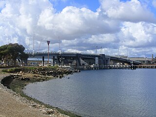
Port Adelaide is a port-side region of Adelaide, approximately 14 kilometres (8.7 mi) northwest of the Adelaide CBD. It is also the namesake of the City of Port Adelaide Enfield council, a suburb, a federal and state electoral division and is the main port for the city of Adelaide. Port Adelaide played an important role in the formative decades of Adelaide and South Australia, with the port being early Adelaide's main supply and information link to the rest of the world. Its Kaurna name, although not officially adopted as a dual name, is Yertabulti.
Taperoo is a suburb in the Australian state of South Australia, located on the Lefevre Peninsula in the west of Adelaide, about 18 kilometres (11 mi) north-west of the Adelaide city centre.
Enfield is a suburb in Adelaide, Australia. The suburb is about a 10-minute drive north from Adelaide city centre. The suburb is bordered by Gepps Cross to the north, Blair Athol to the west, Clearview to the east, and Prospect, Sefton Park and Broadview to the south.
North Haven is a north-western suburb of Adelaide, in the state of South Australia, Australia. It is located 20km from the Central Business District (CBD), and falls under the City of Port Adelaide Enfield. It is adjacent to Osborne and Outer Harbour. It is bounded to the north and east by Oliver Rogers and Victoria Road, to the south by Marmora Terrace and to the west by Gulf St Vincent. The postal code for North Haven is 5018.
Semaphore is a northwestern suburb of Adelaide in the Australian state of South Australia. It is located on the Gulf St Vincent coastline of the Lefevre Peninsula about 14 kilometres (8.7 mi) from the Adelaide city centre.
Largs Bay is a suburb in the Australian state of South Australia located on the Lefevre Peninsula in the west of Adelaide about 16 kilometres (9.9 mi) northwest of the Adelaide city centre.
Peterhead is a north-western suburb of Adelaide 15 km from the CBD, on the Lefevre Peninsula, in the state of South Australia, Australia and falls under the City of Port Adelaide Enfield. It is adjacent to Largs Bay and Birkenhead. The postcode for Peterhead is 5016. It is bounded to the north by Wills Street, to the south by Hargrave Street and in the west and east by the Outer Harbor railway line and the Port River respectively.
Birkenhead is a north-western suburb of Adelaide 14 km from the CBD, on the Lefevre Peninsula, in South Australia, and lies within the City of Port Adelaide Enfield. It is adjacent to Peterhead, Exeter and Glanville. It is bounded to the south by the Gawler Reach of the Port River, to the north by Hargrave Street and in the west and east by the Outer Harbor railway line and the Port River respectively.
Exeter is a suburb of Adelaide, Australia. It is 14 km north-west of the central business district, on the Lefevre Peninsula, and falls under the City of Port Adelaide Enfield. It is adjacent to the suburbs Semaphore, Birkenhead, Largs Bay and Glanville. It is bounded to the south by Exmouth Road, to the north by Hargrave Street and in the east and west by the Outer Harbor railway line and Woolnough Road respectively.
Ethelton is a north-western suburb of Adelaide 13 km (8.1 mi) from the CBD, on the Lefevre Peninsula, in the state of South Australia, Australia. It is a residential suburb within the local government area of City of Port Adelaide Enfield, adjacent to the suburbs of Semaphore, Semaphore South, Glanville and New Port. It is bounded to the north by Hart Street, to the south by Bower Road and in the west by Swan Terrace and in the east by Causeway Road.
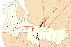
Port Adelaide is a single-member electoral district for the South Australian House of Assembly. Named after Port Adelaide, which it surrounds, it is a 118.8 km2 suburban and industrial electorate on Adelaide's Lefevre Peninsula, and stretches east toward Adelaide's northern suburbs. It contains a mix of seaside residential areas, wasteland and industrial regions. In addition to its namesake suburb of Port Adelaide, the district includes the suburbs of Birkenhead, Bolivar, Cavan, Dry Creek, Ethelton, Exeter, Garden Island, Gepps Cross, Gillman, Glanville, Globe Derby Park, Largs Bay, Largs North, New Port, North Haven, Osborne, Ottoway, Outer Harbor, Peterhead, Semaphore, Semaphore South, St Kilda, Taperoo, Torrens Island, Wingfield, as well as part of Rosewater.
Semaphore South is a beachside suburb of Adelaide, in the City of Port Adelaide Enfield.
The Lefevre Peninsula is a peninsula located in the Australian state of South Australia located about 15 kilometres (9.3 mi) northwest of the Adelaide city centre. It is a narrow sand spit of about 30 square kilometres (12 sq mi) running north from its connection to the mainland.
Devon Park is an inner northern suburb of Adelaide, South Australia. It is located in the cities of Port Adelaide Enfield and Charles Sturt beside the Gawler railway line near, but not meeting, the intersection of Torrens Road and Churchill Road.
Glanville is a north western suburb of Adelaide, in the City of Port Adelaide Enfield.
Semaphore Park is a suburb in the Australian state of South Australia located in the west of Adelaide on the coastline of Gulf St Vincent. The northern end of the suburb is considered to be located within the Lefevre Peninsula.
The District Council of Glanville was a local government area in South Australia from 1864 to 1888.
The City of Woodville was a local government area in South Australia from 1875 to 1993, seated at the inner north west Adelaide suburb of Woodville.