
New Jersey Transit Corporation, branded as NJ Transit or NJTransit and often shortened to NJT, is a state-owned public transportation system that serves the U.S. state of New Jersey and portions of the states of New York and Pennsylvania. It operates buses, light rail, and commuter rail services throughout the state, connecting to major commercial and employment centers both within the state and in its two adjacent major cities, New York City and Philadelphia. In 2023, the system had a ridership of 209,259,800.

NJ Transit Rail Operations is the rail division of NJ Transit. It operates commuter rail service in New Jersey, with most service centered on transportation to and from New York City, Hoboken, and Newark. NJ Transit also operates rail service in Orange and Rockland counties in New York under contract to Metro-North Railroad. The commuter rail lines saw 57,179,000 riders in 2023, making it the third-busiest commuter railroad in North America and the longest commuter rail system in North America by route length.

For the purposes of this article, the Jersey City area extends North to Edgewater, South to Bayonne and includes Kearny Junction and Harrison but not Newark. Many routes east of Newark are listed here.

The Raritan Valley Line is a commuter rail service operated by New Jersey Transit (NJT) which serves passengers in municipalities in Union, Somerset, Middlesex, Essex, and Hunterdon counties in the Raritan Valley region, primarily in central New Jersey and a smaller portion of northern New Jersey, in the United States. The line's most frequent western terminus is Raritan station in Raritan. Some weekday trains continue farther west and terminate at the High Bridge station, located in High Bridge. Most eastbound trains terminate in Newark; passengers are able to transfer to NJ Transit using a combined ticket or PATH and Amtrak to New York City. A limited number of weekday trains continue directly to New York.
Garfield Avenue station is a station on the Hudson–Bergen Light Rail (HBLR) in the Claremont section of Jersey City, New Jersey, United States. Located between the grade crossing at Randolph Avenue and the bridge at Garfield Avenue, the station in a double side platform and two track structure. The station is on the West Side Avenue branch of the Hudson–Bergen Light Rail, which goes from West Side Avenue station to Tonnelle Avenue station in North Bergen. The station is accessible for handicapped people as per the Americans with Disabilities Act of 1990. An elevator is present to get people from Garfield Avenue to track level and the platforms are even with the train cars. The station opened to the public on April 15, 2000 as part of the original operating segment of the Hudson–Bergen Light Rail.

West Side Avenue station is a station on the Hudson–Bergen Light Rail (HBLR) in the West Side neighborhood in Jersey City, New Jersey. Located on the east side of West Side Avenue, the station is the terminal of the West Side Avenue branch of the Hudson–Bergen Light Rail, with service to Tonnelle Avenue station in North Bergen. The station consists of a single island platform and a pair of tracks that end at the station. The station contains a pedestrian bridge over West Side Avenue to a small parking lot and bus stop on the west side of the street. The station is accessible to people with disabilities, with an elevator in the pedestrian overpass and train-level platforms. West Side Avenue station opened on April 15, 2000 as part of the original operating segment of the Hudson–Bergen Light Rail.
Paterson Plank Road is a road that runs through Passaic, Bergen and Hudson Counties in northeastern New Jersey. The route, originally laid in the colonial era, connects the city of Paterson and the Hudson River waterfront. It has largely been superseded by Route 3, but in the many towns it passes it has remained an important local thoroughfare, and in some cases been renamed.
The Newark Plank Road was a major artery between Hudson Waterfront at Paulus Hook and city of Newark further inland across the New Jersey Meadows. As its name suggests, a plank road was constructed of wooden planks laid side-to-side on a roadbed. Similar roads, the Bergen Point Plank Road, the Hackensack Plank Road and Paterson Plank Road, traveled to the locales for which they are named. The name is no longer used, the route having been absorbed into other streets and freeways.
Bergen Hill refers to the lower Hudson Palisades in New Jersey, where they emerge on Bergen Neck, which in turn is the peninsula between the Hackensack and Hudson Rivers, and their bays. In Hudson County, it reaches a height of 260 feet.

The Passaic–Bergen–Hudson Transit Project is a project under study by NJ Transit to reintroduce passenger service on a portion of the New York, Susquehanna and Western Railway (NYSW) right-of-way (ROW) in Passaic, Bergen and Hudson counties using newly built, FRA-compliant diesel multiple unit rail cars. Plans call for service to run from Hawthorne south through Paterson, east to Hackensack and then southeast to North Bergen, where it would join the Hudson-Bergen Light Rail (HBLR).

West Hudson is the western part of Hudson County, New Jersey comprising the contiguous municipalities of Kearny, Harrison and East Newark, which lies on the peninsula between the Hackensack River and Passaic River.

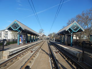
Martin Luther King Drive station is a station of the Hudson–Bergen Light Rail in the Jackson Hill neighborhood of Jersey City, Hudson County, New Jersey. Located on the east side of Martin Luther King Drive near the intersection with Virginia Avenue, the station is a two side platform, two track structure on the West Side Avenue branch of the Hudson–Bergen Light Rail. Train service through Martin Luther King Drive station goes from West Side Avenue in Jersey City to the Tonnelle Avenue station in North Bergen. The station is accessible for those with disabilities as part of the Americans with Disabilities Act of 1990 with ramps to the train-level platform. Martin Luther King Drive station opened on April 15, 2000 along with the rest of the West Side Avenue branch as part of the original operating segment.

Dock Bridge is a pair of vertical lift bridges carrying Amtrak, NJ Transit, and PATH trains across the Passaic River at Newark, Essex County and Harrison, Hudson County, New Jersey, United States. It is the seventh crossing from the river's mouth at Newark Bay and is 5.0 miles (8.0 km) upstream from it. Also known as the Amtrak Dock Vertical Lift, it is listed on the New Jersey and National Registers of Historic Places.

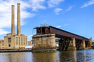
WR Draw is an out-of-service railroad bridge crossing the Passaic River between Newark and the Arlington section of Kearny, New Jersey. The plate girder rim-bearing swing bridge, originally built in 1897 and modified in 1911 and 1950, is the 14th bridge from the river's mouth at Newark Bay and is 8.1 miles (13.0 km) upstream from it. Last used for regular passenger service in 2002, it is welded in closed position as its height is not considered a hazard to navigation.
The PD Draw is a partially dismantled railroad bridge on the Passaic River between Newark and Kearny in the US state of New Jersey. It was built as part of Central Railroad of New Jersey line known as the Newark and New York Branch. The swing bridge is the first crossing upstream from Newark Bay at mile point 1.2.

The Newark Drawbridge, also known as the Morristown Line Bridge, is a railroad bridge on the Passaic River between Newark and Harrison, New Jersey. The swing bridge is the 11th bridge from the river's mouth at Newark Bay and is 5.85 miles (9.41 km) upstream from it. Opened in 1903, it is owned and operated by New Jersey Transit.
The Hackensack Drawbridge was a double-track railroad movable bridge across the mouth of the Hackensack River between Jersey City and Kearny, New Jersey. It was operational until 1946, when a steamship crashed into it.

The Greenway is a planned state park and greenway in the northerneastern New Jersey counties of Essex and Hudson. It will follow an abandoned railroad right of way (ROW) across the New Jersey Meadowlands, over the Hackensack and Passaic rivers, as well pass through densely-populated neighborhoods. The nearly 9-mile (14 km) long shared-use linear park/rail trail will encompass about 135 acres (55 ha) and will average 100 feet (30 m) in width. Running between Jersey City and Montclair it will pass through Secaucus, Arlington in northern Kearny, North Newark, Belleville, Bloomfield and Glen Ridge. The initial phase in Newark and Kearny is expected to open in late 2025.

