KwaDukuza, also known as Stanger, is a municipality in KwaZulu-Natal, South Africa. In 2006, the municipal name was changed to KwaDukuza (which incorporates small towns such as Stanger, Balito, Shaka's Kraal, but the Zulu people in the area called it "Dukuza" well before then.

The Durban Outer Ring Road is a half ring road that circles the coastal city of Durban, South Africa. It is part of the N2 highway which links the North and South Coasts of KwaZulu-Natal.
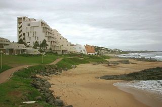
Ballito is an affluent town located in KwaZulu-Natal, South Africa. Ballito is about 40 kilometres (25 mi) north of Durban. It forms part of the KwaDukuza Local Municipality, and iLembe District Municipality. Dolphins are common on this stretch of the North Coast shoreline, hence the nickname Dolphin Coast.
Hillcrest is a town in the KwaZulu-Natal province of South Africa. Organisationally and administratively it is included in the eThekwini Metropolitan Municipality as a suburb of the Outer West region.
Hilton is a small town that lies near the city of Pietemaritzburg in the province of KwaZulu-Natal, South Africa. In 1872 the Reverend William Orde Newnham opened Hilton College on a large estate 7.8km north of the town, which is now one of South Africa's leading private schools.
Pinetown is a large area that is part of the eThekwini Metropolitan Municipality, inland from Durban in KwaZulu-Natal, South Africa. Pinetown is situated 16 km west of Durban at an elevation of 1,000 to 1,300 feet.
Queensburgh is a town in KwaZulu-Natal, South Africa that is situated inland (southwest) from Durban and now forms part of eThekwini, the Greater Durban metropolitan area.
Westville is an area in KwaZulu-Natal, South Africa, and is just west and inland of Durban. It was a formerly independent town however it became part of the eThekwini Metropolitan Municipality in 2002. Westville is situated 10 km inland from the Durban CBD. The climate is subtropical; Westville experiences mild, dry winters, and hot, humid summers with frequent later afternoon downpours.

Mount Edgecombe or Mt Edgecombe is a gated community in KwaZulu-Natal, South Africa, situated just north of Durban, which forms part of eThekwini, the Greater Durban Metropolitan area. It is famous for resorts and golf. It includes a retirement home. It was previously a sugar growing area. The population increased by 89% between 2001 and 2011 from 3,874 to 7,323. Its name is derived from the Earl of Mount Edgecombe in Cornwall, United Kingdom.

eMdloti, alternatively rendered Umdloti and also known as Umdloti Beach, is a small resort village on the KwaZulu-Natal North Coast, South Africa that is situated at the mouth of the Mdloti River north of Durban and now forms part of eThekwini, the Greater Durban Metropolitan Municipality. The name Mdloti is the Zulu word for a species of wild tobacco that grows here.

Verulam is a town 24 kilometres north of Durban in KwaZulu-Natal, South Africa and part of the eThekwini Metropolitan area.

The N2 is a national route in South Africa that runs from Cape Town through George, Gqeberha, East London, Mthatha, Port Shepstone and Durban to Ermelo. It is the main highway along the Indian Ocean coast of the country. Its current length of 2,255 kilometres (1,401 mi) makes it the longest numbered route in South Africa.

uMhlanga, alternatively rendered Umhlanga, is a residential, commercial and resort town north of Durban on the coast of KwaZulu-Natal, South Africa. It is part of the eThekwini Metropolitan Municipality, which was created in 2000 and includes the greater Durban area. The name means "place of reeds" in the Zulu language, and the correct pronunciation of "hl" in uMhlanga is similar to the Welsh "ll".

Salt Rock is a small seaside village just north of Ballito and Shaka's Rock on the Dolphin Coast of KwaZulu-Natal, South Africa. It is a favorite holiday destination for many local South Africans. It is about 40 minutes north of Durban. There are plenty of fishing spots along the coast from Salt Rock, through Shaka's Rock to Ballito and Salmon Bay. Salt Rock owes much of its history to Basil Hulett and his wife Gwen who started not only the Salt Rock Hotel but went on to develop the town of Salt Rock as found today. Nightlife in the small town is limited with a handful of pubs and restaurants offering a variety of food and drinks. A new development, Sheffield Manor, is situated in Salt Rock as well as the newly built Tiffany's Shopping Mall.

KwaMashu is a township 12 kilometres (7.5 mi) north of Durban, South Africa. The name is in honour of Sir Marshall Campbell and means Place of Marshall. KwaMashu is bordered by Newlands East to the south, Newlands West to the west, Ntuzuma to the north, Phoenix to the north-east, Mount Edgecombe to the east and Durban North to the south-east.
KwaDabeka is a township in KwaZulu-Natal, South Africa, located north-west of Durban and means "at the Dabeka location".
The M5 is a long metropolitan route in the eThekwini Metropolitan Municipality, South Africa. It starts in KwaMashu in the north-western townships of Durban. It passes through the townships of KwaMashu, Newlands East, Newlands West, Ntuzuma and KwaDabeka. It then passes through the industrial town of New Germany and the leafy towns of Pinetown and Queensburgh before entering Durban and ending with the R102 in the Umbilo industrial area.
The M45 also named Queen Nandi Drive is a short metropolitan route in the eThekwini Metropolitan Municipality, South Africa. The road connects Briardene in Durban North to KwaMashu.
The M21 is a metropolitan route in the eThekwini Metropolitan Municipality, South Africa linking Durban with Phoenix via Newlands West and KwaMashu.
Springfield Park is an industrial suburb of Durban in KwaZulu-Natal, South Africa located north-east of the city centre.


