

Nine Maidens Downs is a moorland southwest of Four Lanes in Cornwall, England, UK. [2]
Nine Maidens Downs is a moorland southwest of Four Lanes in Cornwall, England, UK. [2]
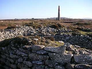
The name Nine Maidens comes from two Early Bronze Age stone circles which stood 18m apart on the downs. There was a belief that the stones were originally young women turned to stone for dancing on the Sabbath. [3]
Originally the south-east circle was 16m across with 14 or 15 stones. Half of this circle survives with a semicircle of five stones, four of which are free standing and the other is built into the Cornish hedge in its original position. At least one other stone still exists but was moved to build the hedge. [3]
The north-west circle had a diameter of about 21m. Two of its stones remain in the hedge but may not be in their original positions. William Borlase noted 10 stones of this circle remaining circa 1760. [3]
Half a mile west of the stone circles, on a prominent ridge, is the massive Bronze Age cairn of Hangman's Barrow. The cairn, built entirely of stone, is 3m high and 20m in diameter. The centre has suffered from past tomb robbing attempts and nothing is known of its original contents. [3]
Nine Maidens is the source of the river Cober which rises between Hangman's Barrow to the west and the Nine Maidens stone circles to the east and runs to the west of the town of Helston before entering the largest natural lake in Cornwall – Loe Pool. [2]
Nine Maidens Board school was erected in 1878 at the northern end of the downs. [4]

The Mên-an-Tol is a small formation of standing stones in Cornwall, UK. It is about three miles northwest of Madron. It is also known locally as the "Crick Stone".
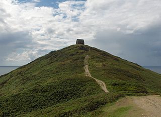
Rame Head or Ram Head is a coastal headland, southwest of the village of Rame in southeast Cornwall, United Kingdom. It is part of the larger Rame Peninsula.
Kelly Rounds, or Castle Killibury is an Iron Age hill fort in Cornwall, England, United Kingdom. It is situated beside the A39 trunk road approximately two miles east of Wadebridge.
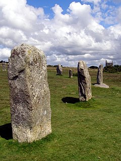
The Hurlers is a group of three stone circles in the civil parish of St Cleer, Cornwall, England, UK. The site is half-a-mile (0.8 km) west of the village of Minions on the eastern flank of Bodmin Moor, and approximately four miles (6 km) north of Liskeard at grid reference SX 258 714.
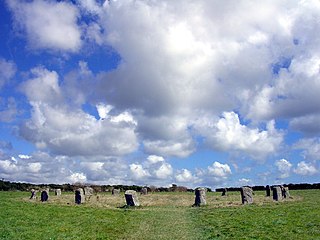
The Merry Maidens, also known as Dawn's Men is a late neolithic stone circle located 2 miles (3 km) to the south of the village of St Buryan, in Cornwall, United Kingdom. A pair of standing stones, The Pipers is associated both geographically and in legend.
Ballowall Barrow is a prehistoric funerary cairn which Ashbee (1982) and Hencken (1902–81) state contains several phases of use from the Neolithic to the Bronze Age. It is situated on the cliff top at Ballowall Common, near St Just in Cornwall, England, UK. It is also known as Carn Gluze Barrow.

The Tregiffian Burial Chamber is a Neolithic or early Bronze Age chambered tomb. It is near Lamorna in west Cornwall, United Kingdom. It is a rare form of a passage grave, known as an Entrance grave. It has an entrance passage, lined with stone slabs, which leads into a central chamber. This type of tomb is also found in the neighbouring Isles of Scilly.

Boscawen-Ûn is a Bronze Age stone circle close to St Buryan in Cornwall, UK. It consists of nineteen upright stones in an ellipse with another, leaning, middle stone just south of the centre. There is a west-facing gap in the circle, which may have formed an entrance. The elliptical circle has diameters 24.9 and 21.9 metres. It is located at grid reference SW412274.

Chapel Carn Brea is an elevated Hercynian granite outcrop, owned by the National Trust at the southern edge of the civil parish of St Just, Cornwall, England, United Kingdom. The hill is 5 kilometres (3.1 mi) south of St Just and 3.5 kilometres (2.2 mi) east of Sennen Cove, and just to the north of the A30 London to Land's End road, which runs through the village of Crows-an-Wra. It should not be confused with another Carn Brea, the hill overlooking the Camborne–Redruth area.

Gurnard's Head is a prominent headland on the north coast of the Penwith peninsula in Cornwall, England, UK. The name is supposed to reflect the fact that the rocky peninsula resembles the head of the gurnard fish.

Tregeseal East is a heavily restored prehistoric stone circle around one mile northeast of the town of St Just in Cornwall, England, United Kingdom. The nineteen granite stones are also known as The Dancing Stones. It is the one surviving circle of three that once stood aligned along an east–west axis on the hillside to the south of Carn Kenidjack.

Boskednan stone circle is a partially restored prehistoric stone circle near Boskednan, around 4 miles northwest of the town of Penzance in Cornwall, United Kingdom. The megalithic monument is traditionally known as the Nine Maidens or Nine Stones of Boskednan, although the original structure may have contained as many as 22 upright stones around its 69-metre perimeter.

St Helen's is one of the fifty or so uninhabited islands in the archipelago of the Isles of Scilly and has an approximate area of 0.1885 square kilometres. On the south side of the island is one of the earliest Christian sites in Scilly, an early medieval religious complex, which is thought to be the remains of St Elidius Hermitage, an 8th-century chapel lived in by Saint Lide,. There are also the remains of an isolation hospital used to quarantine sailors with plague. The island is the major part of a Site of Special Scientific Interest and some features have been given the designation of scheduled ancient monument. Access to the island is through chartered or private boat, although there are some season trips throughout the summer. St Helen's is currently managed by the Isles of Scilly Wildlife Trust.

Bosporthennis is a hamlet south of Treen in the civil parish of Zennor on the Penwith peninsula in west Cornwall, England, United Kingdom.
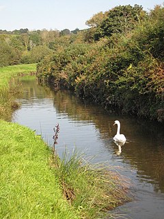
The River Cober is a short river in west Cornwall, England, United Kingdom. The river runs to the west of Helston into The Loe, Cornwall's largest natural lake.
Sancreed Beacon is a Bronze Age archaeological site near the village of Sancreed in the Penwith peninsula of Cornwall maintained by the Cornwall Heritage Trust. On top of the hill are several stone cists and Bronze Age archaeological remains comprising burial mounds and the remains of a Bronze Age hut on the Western slope.

Calvadnack is a 130 acres area of heathland 3.7 miles (6.0 km) south-east of Camborne in Cornwall, England, UK. Calvadnack is in the civil parish of Wendron. Calvadnack is south-west of the hill of Carnmenellis. In the centre of the moor are the remains of an Iron Age settlement consisting of four round houses.

Grumbla is a hamlet in the parish of Sancreed, Cornwall, England, UK.
This is a list of scheduled monuments in Cornwall, United Kingdom. Monuments are listed by Historic England as part of the National Heritage List for England. For the scope of this list, the Isles of Sicily are included and the ceremonial county boundaries are used.

Wet Withens is a Bronze Age henge on Eyam Moor in the Derbyshire Peak District, England. The prehistoric circle of 10 upright stones (orthostats) is a protected Scheduled Monument.
| Unitary authorities | |
|---|---|
| Major settlements |
|
| Rivers | |
| Topics | |