North Avondale, Colorado

Last updated

North Avondale, Colorado
USA Colorado location map.svg
Red pog.svg
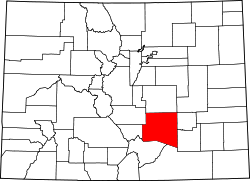
Location in Pueblo County and the state of Colorado
Usa edcp location map.svg
Red pog.svg
North Avondale, Colorado (the United States)
Coordinates: 38°15′42″N104°20′56″W / 38.26167°N 104.34889°W / 38.26167; -104.34889
Country Flag of the United States.svg  United States
State Flag of Colorado.svg  Colorado
County Pueblo [1]
Elevation
[1]
4,518 ft (1,377 m)
Time zone UTC-7 (MST)
  Summer (DST) UTC-6 (MDT)
ZIP code [2]
81022 (Avondale)
Area code 719
GNIS feature ID 0193754

North Avondale is an unincorporated community in Pueblo County, Colorado, United States. The U.S. Post Office at Avondale (ZIP Code 81022) now serves North Avondale postal addresses. [2]

Geography

North Avondale is located at 38°15′42″N104°20′56″W / 38.26167°N 104.34889°W / 38.26167; -104.34889 (38.261637,-104.349003).

Related Research Articles

<span class="mw-page-title-main">Northglenn, Colorado</span> City in Colorado, United States

The City of Northglenn is a home rule municipality located in Adams and Weld counties, Colorado, United States. Northglenn is a part of the Denver–Aurora–Lakewood, CO Metropolitan Statistical Area. As of the 2020 census the city's population was 38,131. It was built as a master planned community in 1959 by Jordon Perlmutter.

<span class="mw-page-title-main">Hudson, Colorado</span> Town in Colorado, United States

The Town of Hudson is a home rule municipality in Weld County, Colorado, United States. The population was 1,651 at the 2020 census.

<span class="mw-page-title-main">Pierce, Colorado</span> Town in Colorado, United States

Pierce is a Statutory Town in Weld County, Colorado, United States. The population was 1,097 at the 2020 census. The town is a rural agricultural community located on the Colorado Eastern Plains along U.S. Highway 85 north of Greeley.

<span class="mw-page-title-main">Hoyt, Colorado</span> Unincorporated community in Colorado, United States

Hoyt is a small unincorporated community in Morgan County, Colorado, United States. The 1,996-foot (608-meter) high Hoyt Radio Tower is located near Hoyt. The community was named after James A. Hoyt, an early settler.

Galeton is an unincorporated community and U.S. Post Office in Weld County, Colorado, United States. The Galeton Post Office has the ZIP Code 80622.

Gill is an unincorporated community and a U.S. Post Office in Weld County, Colorado, United States. The Gill Post Office has the ZIP Code 80624.

<span class="mw-page-title-main">Hereford, Colorado</span> Unincorporated community in Colorado, United States

Hereford is an unincorporated community and a U.S. Post Office in Weld County, Colorado, United States. The Hereford Post Office has the ZIP Code 80732.

Lucerne is an unincorporated community and a U.S. Post Office in Weld County, Colorado, United States. The Lucerne Post Office has the ZIP Code 80646.

<span class="mw-page-title-main">Model, Colorado</span> Unincorporated community in Colorado, United States

Model is an abandoned unincorporated village in Las Animas County, Colorado, United States. The Model Post Office serving ZIP Code 81059 was in operation from 1912 to 2021, and was the last business or service standing there for many years. The community originally was a planned, or "model" community, hence the name.

<span class="mw-page-title-main">Roggen, Colorado</span> Unincorporated community in Colorado, United States

Roggen is an unincorporated community and a U.S. Post Office in Weld County, Colorado, United States. The Roggen Post Office has the ZIP Code 80652.

<span class="mw-page-title-main">Rush, Colorado</span> Unincorporated community in State of Colorado, United States

Rush is an unincorporated community and a U.S. Post Office located in El Paso County, Colorado, United States. The Rush Post Office has the ZIP Code 80833.

<span class="mw-page-title-main">Trinchera, Colorado</span> Unincorporated community in Colorado, United States

Trinchera is an unincorporated community and a U.S. Post Office located in Las Animas County, Colorado, United States. The Trinchera Post Office has the ZIP Code 81081.

Boyero is an unincorporated community in Lincoln County, Colorado, United States. The U.S. Post Office at Hugo now serves Boyero postal addresses.

<span class="mw-page-title-main">Delhi, Colorado</span> Unincorporated community in State of Colorado, United States

Delhi is an unincorporated community in Las Animas County, Colorado, United States. The U.S. Post Office at Model now serves Delhi postal addresses.

<span class="mw-page-title-main">Maher, Colorado</span> Unincorporated community in Colorado, United States

Maher is an unincorporated community located in Montrose County, Colorado, United States. The U.S. Post Office at Crawford now serves Maher postal addresses.

Sopris was an unincorporated community located in Las Animas County, Colorado, United States. The town is now under the surface of Trinidad Lake in Trinidad Lake State Park.

<span class="mw-page-title-main">Thatcher, Colorado</span> Unincorporated community in Colorado, United States

Thatcher is an unincorporated community located in Las Animas County, Colorado, United States. The U.S. Post Office at Model now serves Thatcher postal addresses.

<span class="mw-page-title-main">Tyrone, Colorado</span> Unincorporated community in Colorado, United States

Tyrone is an unincorporated community located in Las Animas County, Colorado, United States. The U.S. Post Office at Model now serves Tyrone postal addresses.

Wattenburg or Wattenberg is an unincorporated community located in Weld County, Colorado, United States. The U.S. Post Office at Fort Lupton now serves Wattenburg postal addresses.

<span class="mw-page-title-main">Prospect Valley, Colorado</span> Populated Place in Colorado, United States

Prospect Valley is a populated place in Weld County, Colorado, United States. The Post Office at Keenesburg serves the Prospect Valley postal address. SH 52 runs east and west through the community.

References

  1. 1 2 "US Board on Geographic Names". United States Geological Survey. October 25, 2007. Retrieved January 31, 2008.
  2. 1 2 "ZIP Code Lookup". United States Postal Service. January 3, 2007. Archived from the original (JavaScript/HTML) on January 1, 2008. Retrieved January 3, 2007.