Avondale, Colorado

Last updated
Avondale, Colorado
Avondale, Colorado post office.JPG
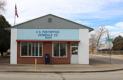
Avondale post office.
Pueblo County Colorado Incorporated and Unincorporated areas Avondale Highlighted.svg
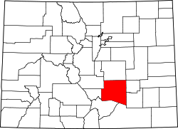
Location of the Avondale CDP in Pueblo County, Colorado.
Usa edcp location map.svg
Red pog.svg
Avondale
Location of Avondale, Colorado.
USA Colorado location map.svg
Red pog.svg
Avondale
Avondale (Colorado)
Coordinates: 38°14′15″N104°21′04″W / 38.2375°N 104.3511°W / 38.2375; -104.3511 [1]
Country United States
State Colorado
County Pueblo [2]
Government
  Type unincorporated community
  Body Pueblo County [2]
Area
[3]
  Total
0.628 sq mi (1.627 km2)
  Land0.628 sq mi (1.627 km2)
  Water0.000 sq mi (0.000 km2)
Elevation
[1]
4,557 ft (1,389 m)
Population
 (2020) [3]
  Total
594
  Density950/sq mi (370/km2)
Time zone UTC−07:00 (MST)
  Summer (DST) UTC−06:00 (MDT)
ZIP Code [4]
81022
Area code 719
GNIS pop ID 204801
GNIS CDP ID 2407788
FIPS code 08-04165

Avondale is a census-designated place (CDP) and post office located in Pueblo County, Colorado, United States. The CDP is a part of the Pueblo, CO Metropolitan Statistical Area. The Avondale post office has the ZIP Code 81022. [4] At the United States Census 2020, the population of the Avondale CDP was 594, while the population of the 81022 ZIP Code Tabulation Area was 1,624 including adjacent areas. [3]

Contents

History

The Avondale, Colorado, post office opened on March 22, 1892. [5] The name Avondale is derived from Stratford-upon-Avon. [6]

Geography

At the 2020 United States census, the Avondale CDP had an area of 402 acres (1.627 km2), all land. [3]

Demographics

Avondale CDP, Colorado
YearPop.±%
2000 754    
2010 674−10.6%
2020 594−11.9%
Source: United States Census Bureau


The United States Census Bureau initially defined the Avondale CDP for the United States Census 2000.

Education

It is in the Pueblo County School District 70. [7] Zoned schools include Avondale Elementary School, [8] Vineland Middle School, [9] and Pueblo County High School. [10]

Avondale was first zoned to Pueblo County High in 1953. Prior to that year, its high school was Avondale High School. [11]

See also

References

  1. 1 2 "Avondale, Colorado". Geographic Names Information System . United States Geological Survey, United States Department of the Interior . Retrieved December 31, 2024.
  2. 1 2 "Colorado Counties". Colorado Department of Local Affairs . Retrieved January 20, 2025.
  3. 1 2 3 4 "State of Colorado Census Designated Places - BAS20 - Data as of January 1, 2020". United States Census Bureau . Retrieved November 3, 2021.
  4. 1 2 "Look Up a ZIP Code". United States Postal Service . Retrieved December 26, 2020.
  5. Bauer, William H.; Ozment, James L.; Willard, John H. (1990). Colorado Post Offices 1859–1989. Golden, Colorado: Colorado Railroad Historical Foundation. ISBN   0-918654-42-4.
  6. Dawson, John Frank (1954). Place names in Colorado: why 700 communities were so named, 150 of Spanish or Indian origin. Denver, CO: The J. Frank Dawson Publishing Co. p. 8.
  7. Geography Division (December 17, 2020). 2020 CENSUS - SCHOOL DISTRICT REFERENCE MAP: Pueblo County, CO (PDF) (Map). U.S. Census Bureau . Retrieved 2025-08-04. - Text list
  8. Pueblo School District No. 70 Elementary School Boundaries (PDF) (Map). Pueblo County School District 70 . Retrieved 2025-08-05.
  9. Pueblo School District No. 70 Middle School Boundaries (PDF) (Map). Pueblo County School District 70 . Retrieved 2025-08-05.
  10. Pueblo School District No. 70 High School Boundaries (PDF) (Map). Pueblo County School District 70 . Retrieved 2025-08-05.
  11. Perez, Gayle (2003-09-28). "County High built after consolidation". The Pueblo Chieftain . Retrieved 2025-08-05.