Autobees, Colorado

Last updated

Autobees
Extinct settlement
Autobees, Colorado.JPG
The Autobees site in 2023
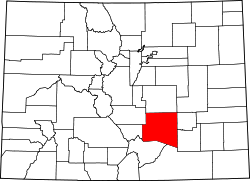
USA Colorado location map.svg
Red pog.svg
Autobees
Coordinates: 38°12′36″N104°17′14″W / 38.2100°N 104.2872°W / 38.2100; -104.2872 (Autobees)
CountryUnited States
StateColorado
County Pueblo
Nearest town Boone

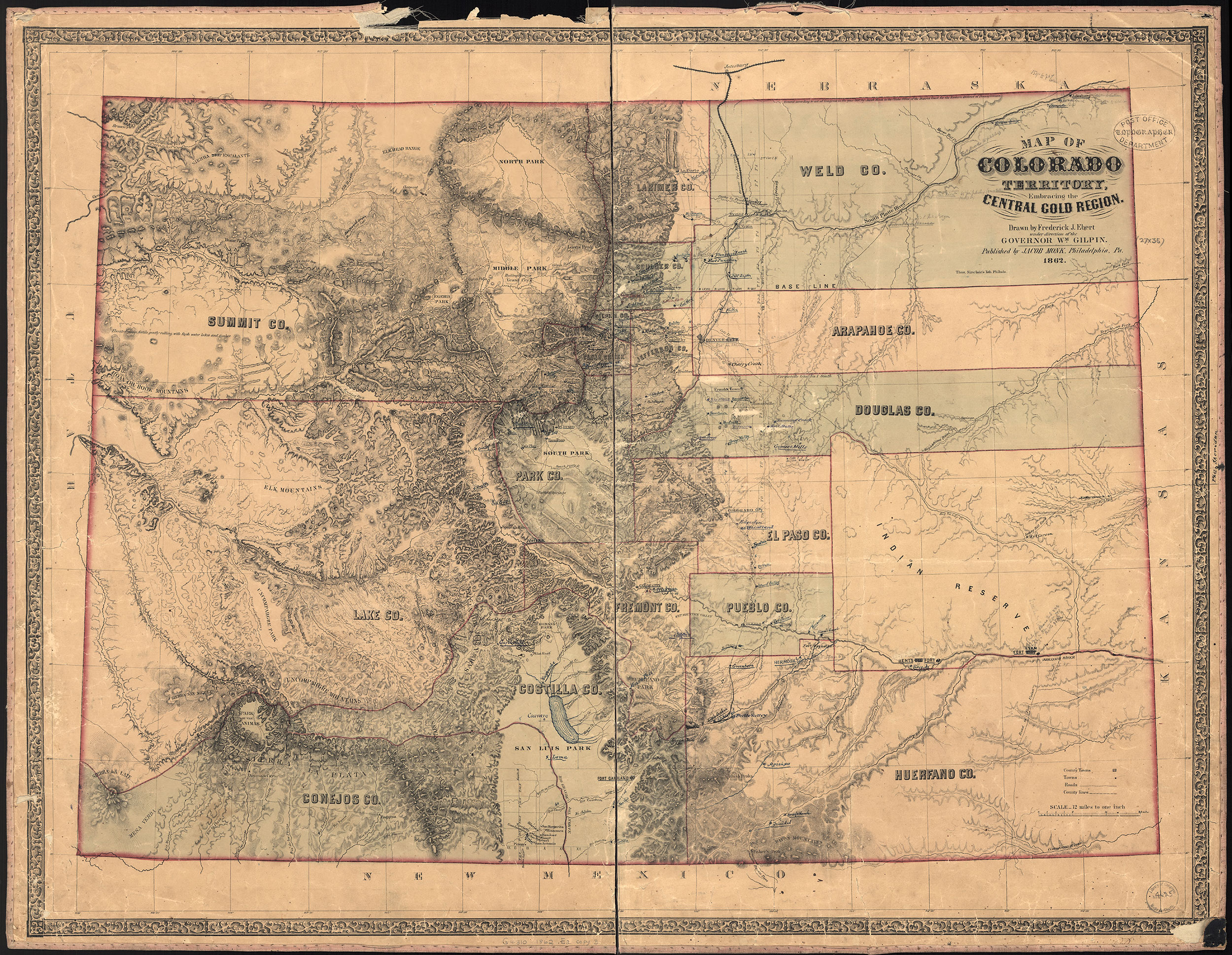
Autobees, also known as Autobees Plaza, is an extinct town located in Huerfano County, Colorado, United States. Founded in 1853, Autobees Plaza was the original seat of Huerfano County, Colorado Territory from its creation on November 1, 1861 until 1868. In 1868, the county seat moved to Badito, which was on a main trail along the foothills. [1] [2] When Autobees was the county seat, Huerfano County was almost the entire southeastern portion of the state. [3] Now, the site of the former settlement is within Pueblo County, Colorado. [1] [4]

Contents

History

Fort Huerfano

Charles Autobees had a small encampment about 1845 or 1846 on the Huerfano River. The site later became the county seat of Huerfano County. [5] [6] The encampment has been called Fort Huerfano. [7] Across the Arkansas River from the mouth of the Huerfano River was an old Cherokee trail and campground, which is now the town of Boone, Colorado. [8]

Settlement

He left Taos, New Mexico and settled in the area in 1853, establishing a ranch two miles from the confluence of the Arkansas and Huerfano Rivers. [1] He built the ranch within the four million acre Vigil and St. Vrain Land Grant, a Mexican land grant. [9] His goal was to establish a colony near his ranch. [1] There were Native American and Mexican people living at his ranch. [10] The settlement was also called New Huerfano. [11]

He and other residents of the settlement farmed the land, using irrigation ditches for watering the plants. [12] [13] Autobees ran a ferry service across the Arkansas River, which was used by soldiers of the nearby Fort Reynolds. [14] He remained at his ranch until his death. There are no remains of the ranch due to floods and other issues, but there is a monument to Charles Autobees near the site. [1]

See also

Related Research Articles

<span class="mw-page-title-main">Kersey, Colorado</span> Town in Weld County, Colorado, United States

The Town of Kersey is a Statutory Town in Weld County, Colorado, United States. The population was 1,495 at the 2020 United States Census.

<span class="mw-page-title-main">John David Albert</span> American mountain man (1810–1899)

John David Albert was an American mountain man.

South-Central Colorado is a region of the U.S. state of Colorado. It can be roughly defined by Chaffee County in the northwest, El Paso County in the northeast, Las Animas County in the southeast, and Conejos County in the southwest. Some notable towns and cities there include Colorado Springs, Pueblo, Cripple Creek, Cañon City, Salida, Buena Vista, Monte Vista, Alamosa, Walsenburg, and Trinidad. The landscapes of South-Central Colorado were made known to the Western world by the explorations of Zebulon Pike and Kit Carson, who were later followed by settlers, many of whom came by the Santa Fe Trail. The upper tributaries of the Arkansas River and South Platte River provide ample whitewater rafting and are famous for trout and bass fishing in scenic settings such as Royal Gorge. Much of the local economic system is dependent on mining, forestry, ranching, and tourism related to these endeavors. South-Central Colorado has so far largely escaped urbanization, allowing visitors to experience something of the American Old West.

<span class="mw-page-title-main">Badito, Colorado</span>

Badito is a ghost town along the Huerfano River in Huerfano County, Colorado, United States. It is located at the intersection of Colorado State Highway 69 and County Road 520. A post office named Little Orphan, Colorado opened on May 1, 1865, but the name was changed to Badito on September 12, 1865. Badito served as the Huerfano County seat from 1868 to 1874. The Badito post office closed on November 15, 1910.

Fort Morgan, first called Camp Tyler and Camp Wardwell, was established in the present-day city of Fort Morgan in Morgan County, Colorado as a U.S. military post in 1864. It operated until 1868. There is a historical marker in a city park in remembrance of its history.

<span class="mw-page-title-main">Trapper's Trail</span> Historical trail or road

The Trapper's Trail or Trappers' Trail is a north-south path along the eastern base of the Rocky Mountains that links the Great Platte River Road at Fort Laramie and the Santa Fe Trail at Bent's Old Fort. Along this path there were a number of trading posts, also called trading forts.

Fort Le Duc or Fort LeDuc was a square fort and trading post built near Wetmore, Colorado. It was named after trapper Maurice LeDuc or Maurice LeDoux, and constructed around 1830 or 1835.

The Fort Pueblo massacre was an attack that occurred on December 25, 1854, against Fort Pueblo, Colorado, also known as El Pueblo, a settlement on the north side of the Arkansas River, 12 mile west of the mouth of Fountain Creek, above the mouth of the Huerfano. The attack followed the deaths of Chief Chico Velasquez and others who died of smallpox after having been given blanket coats which the Muache believed had been deliberately contaminated. Coalition forces of over 100 Muache Utes and Jicarilla Dindes under the leadership of Chief Tierra Blanco led the attack against Fort Pueblo, killing 15 men, and capturing one woman, and two boys. Later on, the Muache killed the woman south of Pueblo at the Salt Creek. 2 women and 1 man survived the joint military operation, and the two boys who were captured, eventually returned.

<span class="mw-page-title-main">Teresita Sandoval</span> Co-founder of El Pueblo (1811-1894)

Maria Teresa "Teresita" Sandoval Suazo (1811–1894) was among the first women of European heritage to live in the Arkansas Valley of present-day Colorado. She is one of the founders of El Pueblo in the current city of Pueblo, Colorado. She managed a ranch, the Doyle Settlement, in her later years.

<span class="mw-page-title-main">Charles Autobees</span> Fur trader and American pioneer

Charles Autobees (1812–1882), whose last name was also spelled Urtebise and Ortivis, was a fur trader and pioneer in the American Old West. He was the founder of Autobees, Colorado.

El Pueblo, also called Fort Pueblo, was a trading post and fort near the present-day city of Pueblo in Pueblo County, Colorado. It operated from 1842 until 1854, selling goods, livestock, and produce. It was attacked in 1854, killing up to 19 men and capturing three people. A recreation of the fort is located at the El Pueblo History Museum at the site of the original fort.

Milk Fort, also known as Fort Leche, Pueblo de Leche, Fort El Puebla, Peebles Fort, and Fort Independence was a trading post and settlement in Otero County, Colorado in the late 1830s. There are no remains of the settlement.

<span class="mw-page-title-main">Montoya Ranch</span> United States historic place

Montoya Ranch was a ranch in Farisita, Huerfano County, Colorado, United States, along the Huerfano River. It was listed on the National Register of Historic Places in 2012. The ranch house was built in or after 1867 with Spanish Colonial and territorial architectural elements. At that time, there were many New Mexicans moving to Colorado, and many ranched and farmed in the Huerfano valley.

Alexander Barclay was an American frontiersman. After working in St. Louis as a bookkeeper and clerk, he worked at Bent's Old Fort. He then ventured westward where he was a trapper, hunter, and trader. Barclay entered into a common-law relationship with Teresita Sandoval, one of the founders of the settlement and trading post El Pueblo. He helped settle Hardscrabble, Colorado and built Fort Barclay in New Mexico.

Jimmy's Camp was a trading post established in 1833. The site is east of present-day Colorado Springs, Colorado on the southeast side of U.S. Route 24 and east of the junction with State Highway 94. Located along Trapper's Trail / Cherokee Trail, it was a rest stop for travelers and was known for its spring. Jimmy Camp was a ranch by 1870 and then a railway station on a spur of the Colorado and Southern Railway. After the ranch was owned by several individuals, it became part of the Banning Lewis Ranch. Now the land is an undeveloped park in Colorado Springs.

<span class="mw-page-title-main">Franceville, Colorado</span>

Franceville was a coal mining town and railroad post office in eastern El Paso County, Colorado, about five miles from the town of Falcon and twelve miles east of Colorado Springs. The Franceville post office operated from November 2, 1881, until May 14, 1894. The town was located on land owned by Matt France. There were 120 people in the town in 1885.

References

  1. 1 2 3 4 5 Jessen, Kenneth (February 24, 2018). "Autobees Ranch, a county seat abandoned". Loveland, Colorado. Retrieved June 6, 2018 via Reporter Herald.
  2. Thomas J. Noel (May 29, 2015). Colorado: A Historical Atlas. University of Oklahoma Press. pp. 74, 160. ISBN   978-0-8061-5353-7.
  3. Federal Writers' Project (October 31, 2013). The WPA Guide to Colorado: The Highest State. Trinity University Press. p. PT296. ISBN   978-1-59534-205-8.
  4. Frank Hall (1895). History of the State of Colorado, Embracing Accounts of the Pre-historic Races and Their Remains. Blakely print. Company. p.  191.
  5. Frank Hall (1891). History of the State of Colorado, Embracing Accounts of the Pre-historic Races and Their Remains. Blakely print. Company. p. 446.
  6. Colorado Magazine. State Historical Society of Colorado, State Museum. 1966. p. 281.
  7. Phil Payette; Pete Payette. "Colorado forts - Fort Huerfano". American Forts Network. Retrieved June 6, 2018.
  8. Elliott Coues (September 22, 2013). The Expeditions of Zebulon Montgomery Pike To Headwaters of the Mississippi River Through Louisiana Territory, and in New Spain, During the Years 1805-6-7. Library of Alexandria. p. PT840. ISBN   978-1-4655-8627-8.
  9. Thomas J. Noel (May 29, 2015). Colorado: A Historical Atlas. University of Oklahoma Press. pp. 52, 53. ISBN   978-0-8061-5353-7.
  10. Frank Hall (1895). History of the State of Colorado, Embracing Accounts of the Pre-historic Races and Their Remains. Blakely print. Company. p.  74.
  11. Perry Eberhart (June 1986). Ghosts of the Colorado plains. Swallow Press. p. 71. ISBN   978-0-8040-0832-7.
  12. Charlene Garcia Simms; Maria Sanchez Tucker; Jeffrey DeHerrera; Pueblo City-County Library District (January 16, 2017). Pueblo. Arcadia Publishing Incorporated. p. PT28. ISBN   978-1-4396-5912-0.
  13. Wilbur Fiske Stone (1918). History of Colorado. S. J. Clarke. pp.  478–479.
  14. Kay Beth Faris Avery (December 5, 2016). Along the Huerfano River. Arcadia Publishing Incorporated. p. 30. ISBN   978-1-4396-5872-7.

Further reading