
The Hotchkissville Historic District is a historic district in the town of Woodbury, Connecticut, United States that was listed on the National Register of Historic Places in 1995. The district encompasses most of the historic village of Hotchkissville, which is centered at the junction of Washington and Weekeepeemee roads. The village began as a dispersed rural agricultural community, but developed in the 19th century with the arrival of industry, primarily the manufacture of textiles. Despite this, the village has retained a significantly rural character, and includes a broad cross-section of 18th- and 19th-century architectural styles.

Mill River Historic District is a historic district encompassing the traditional center of government and a former industrial mill village along the Konkapot River in the village of Mill River in New Marlborough, Massachusetts. The district is roughly bounded by Main Street and River Church, Southfield, Clayton, School, and Hayes Hill Roads. It encompasses about 425 acres (172 ha), and contains mostly 19th century residential and civic buildings, as well as remnants of 19th century industrial activity.
The West Whately Historic District is a historic district encompassing over 700 acres (280 ha) of western Whately, Massachusetts. The area, located in the foothills of The Berkshires above the Connecticut River, has a long agricultural history, but also experienced a surge of industrial activity in the 19th century, of which only fragments remain. The district, listed on the National Register of Historic Places in 2003, is focused on the areas surrounding West Brook and the areas where there was once industrial activity. From the late 18th century into the early 20th, there were some 16 mill complexes in the area, of which only one still has a surviving structure. The principal elements that survive of this industrial past are foundations and evidence of water works such as dams and millraces. There are only two institutional buildings in the district: the West Whately Chapel, built in the Queen Anne style in 1896, and a schoolhouse that has since been converted to a residence.

The Cushman Village Historic District is a historic district encompassing a portion of the Cushman Village area of Amherst, Massachusetts, which was a significant mill village during the 19th century. It is centered on the triangle formed by Bridge, Henry, and Pine Streets in northeastern Amherst, and arose because of the presence of falls on the Mill River, whose water power was harnessed for mills as early as the mid-18th century. Two houses survive from the colonial period. The village, although it was defined for many years by the mills, no longer has any industrial buildings, as they were demolished or destroyed by fire. Most of the houses in the district were built before 1860, the peak of the village's industrial activity. The district was listed on the National Register of Historic Places in 1992.

The Williamsburg Center Historic District is a historic district on Massachusetts Route 9 in Williamsburg, Massachusetts. It encompasses the traditional center of the town, which was settled in the 18th century and grew to prosperity in the mid-19th century. It was listed on the National Register of Historic Places in 1980.

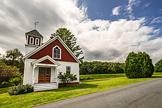
The South Worthington Historic District is a historic district encompassing the formerly industrial, but now rural, village of South Worthington, Massachusetts. The village is centered on the junction of Huntington Road, Ireland Street, and Thrasher Hill Road. The district extends along Ireland Road as far as Conwell Road, and one contributing element, the dam which impounds Little Galilee Pond, extends into neighboring Chesterfield. The area had a number of small mills along the banks of the Little River, a tributary of the Westfield River, but only one complex, the Theron Higgins Mill on South Worthington Road, has survived from the 19th century. Most of the buildings in the district are residences dating to the 19th century; also included are three churches, including the particularly elegant Greek Revival South Worthington Methodist Church (1848). The district was added to the National Register of Historic Places in 2005.

The North Amherst Center Historic District encompasses the center of North Amherst, part of the town of Amherst, Massachusetts. It is a well-preserved example of a traditional farming village, centered at the five-way junction of Meadow, Pine, and North Pleasant Streets, and Sunderland and Montague Roads. The area developed as a village center in the early 19th century and has been relatively little changed since the late 19th century. The district was added to the National Register of Historic Places in 1991.
The North Chester Historic District is a historic district encompassing the rural village center of North Chester in the town of Chester, Massachusetts. One of the rural community's early settlement nodes, it thrived into the early 19th century around a stagecoach tavern, a few small mills, and farming, and retains buildings and archaeological remains representative of this history. The district was listed on the National Register of Historic Places in 1998.

The North Hadley Historic District encompasses the historic rural village of North Hadley, located between Mount Warner and the Connecticut River in Hadley, Massachusetts. It includes properties on River Drive between Stockwell Road and Stockbridge Street, and includes properties on French, Meadow and Mt. Warner Streets. It is a well-preserved example of a rural farming and mill community, with architecture dating from the late 18th to early 20th centuries. The district was listed on the National Register of Historic Places in 1993.

The Shirley Village Historic District encompasses the main commercial and industrial village of Shirley, Massachusetts. It is located in the southern part of the town, and grew up around a series of mills that were located along Catacoonamug Brook, and then the railroad, which was built through the area in the 1840s. The district contains 441 properties. It is roughly bounded by Center, Harvard, Leominster and Shaker Roads. The district was listed on the National Register of Historic Places in 1992.

The Waterville Village Historic District encompasses most of the history 19th and early 20th-century village center of Waterville, Vermont. The village grew from beginnings late in the 18th century to serve as a modest civic, commercial, and residential hub for the rural community. It was added to the National Register of Historic Places in 2007.

The Leverett Center Historic District is an expansive 467-acre (189 ha) historic district encompassing the historic heart of the rural community of Leverett in eastern Franklin County, Massachusetts. The district is focused on a two-mile stretch of Depot and Montague Roads, at whose center is the civic heart of the town. It includes the 1838 Greek Revival First Congregational Church, the town hall, whose present form was achieved in 1895 by raising the 1845 construction and building a first floor underneath it, and the Colonial Revival Field Memorial Library (1916). It also includes a town pound built c. 1822, and a number of 18th century residences. The district was listed on the National Register of Historic Places in 2008.

The East Leverett Historic District of Leverett, Massachusetts, encompasses the historic mill village of East Leverett. Centered on the intersection of Cushman Road and Shutesbury Road in the southeastern portion of the rural town, it includes predominantly residential buildings that were built during the height of the area's industrial activity in the first four decades of the 19th century. The architecture is mainly Federal and Greek Revival in style. The district was listed on the National Register of Historic Places in 2014.

The Head of the River Historic District is a historic district encompassing a village area at the head of navigation of the Acushnet River, which separates Acushnet and New Bedford, Massachusetts. The village is centered at the junction of Tarkin Hill Road, River Road, and Mill Road in New Bedford, and Main Street in Acushnet. The area went through two significant periods of development: the first was in the late 18th and early 19th century, and the second was in the early 20th century. The district was listed on the National Register of Historic Places in 2009.

The Bennington Village Historic District of Bennington, New Hampshire encompasses the 19th-century center of the village. Growth of the village followed a typical pattern for rural New Hampshire towns, based in this case around the growth in the early 19th century of the paper industry, which continues to be a significant economic force in the community. The district is centered on the junctions of Main, Center, and School Streets with Bible Hill Road and Francestown Road. The district was listed on the National Register of Historic Places in 2010.

The Moore's Corner Historic District of Leverett, Massachusetts, encompasses the historic rural mill village of Moore's Corner. Centered on the intersection of North Leverett Road with Dudleyville Road, Church Hill Road, and Rattlesnake Gutter Road, it includes 15 houses and several other buildings, mainly from the village's mid-19th century peak as a modest rural village center. The district was listed on the National Register of Historic Places in 2014.
The Springfield Downtown Historic District encompasses the historic central business district of the town of Springfield, Vermont. Located in a narrow valley on the banks of the Black River, the town's architecture is primarily reflective of its importance as a manufacturing center in the late 19th and early-to-mid 20th centuries, with a cluster of commercial buildings surrounded by residential and industrial areas. It was listed on the National Register of Historic Places in 1983, and enlarged slightly in 1986.

The Thetford Center Historic District encompasses the village of Thetford Center in Thetford, Vermont. The village contains a well-preserved collection of early to mid-19th century architecture, a legacy of its period of greatest prosperity as an agricultural and industrial center. It was listed on the National Register of Historic Places in 1998.
The Moscow Village Historic District encompasses a former 19th-century industrial village in southern Stowe, Vermont. Centered on the Little River at its Moscow Road crossing, the village prospered into the early 20th century as a woodworking center. It was listed on the National Register of Historic Places in 2008.

The Manchaug Village Historic District is a historic district encompassing the 19th century industrial village center of Manchaug in Sutton, Massachusetts. Developed in the 1820s around textile mills on the Mumford River, it was the largest industrial area in Sutton, with at least three mill complexes in operation. The district is centered on the junction of Main Street with Manchaug, Putnam Hill, and Whitins Roads.


