New Boston is an unincorporated community in Wayne County in the U.S. state of Michigan. The community is located within Huron Charter Township. As an unincorporated community, New Boston has no legally defined boundaries or population statistics of its own.

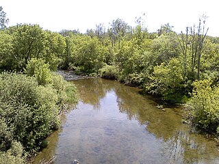
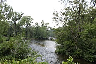
The Huron River is a 130-mile-long (210 km) river in southeastern Michigan, rising out of the Huron Swamp in Springfield Township in northern Oakland County and flowing into Lake Erie, as it forms the boundary between present-day Wayne and Monroe counties. Thirteen parks, game areas, and recreation areas are associated with the river, which passes through the cities of Dexter, Ann Arbor, Ypsilanti, Belleville, Flat Rock and Rockwood that were developed along its banks.
The Clinton River is a river in southeastern Michigan in the United States. It is named in honor of DeWitt Clinton, who was governor of New York from 1817 to 1823.

The Huron–Clinton Metroparks system is a regional park system in Metro Detroit in the U.S. state of Michigan. The park system includes 13 parks totaling more than 24,000 acres (97 km2) arranged along the Huron River and Clinton River forming a partial ring around the metro area. Plans are in development to finish the ring by building hike/bike trails to connect all the parks as a green belt. The parks draw about 7.5 million visitors a year, down from a peak of 10 million in 2009. The park system is primarily tax-funded with a $50 million annual budget. The system provides employment for 200 full-time and part-time employees year-round and 1,000 additional summer workers. The rivers are prime fishing and canoeing streams with Delhi Metropark including a short rapids, which while runnable, is the only point other than dams on either stream normally portaged.

Downriver is the unofficial name for a collection of 18 cities and townships in Wayne County, Michigan, south of Detroit, along the western shore of the Detroit River.

Stony Creek Metropark is a Huron-Clinton Metropark located in southeast Michigan in the outskirts of metro Detroit. The park is predominantly in Washington Township and Oakland Township, with a small portion in Shelby Township. The park covers 4,461 acres (18.05 km2) with Stony Creek Lake at its center.

Wolcott Mill Metropark is a Huron-Clinton Metropark located in rural Ray Township, Michigan. The northern branch of the Clinton River is a fixture of the park as it bisects the entirety of the park.
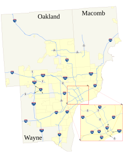
The roads and freeways in metropolitan Detroit comprise the main thoroughfares in the region. The freeways consist of an advanced network of interconnecting freeways which include Interstate highways. The Metro Detroit region's extensive toll-free freeway system, together with its status as a major port city, provide advantages to its location as a global business center. There are no toll roads in Michigan.
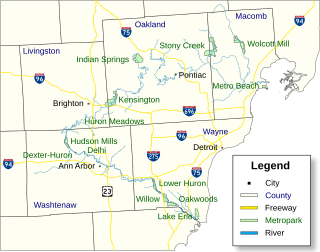
Indian Springs Metropark is a park in the Huron-Clinton system of metro parks in the US state of Michigan. The headwaters of the Huron River lie within its boundaries.

Kensington Metropark is a unit of the Huron–Clinton Metroparks system located between Milford and South Lyon, Michigan, USA. The park covers 4,543 acres (18.13 km2). It has wooded hilly terrain and surrounds 1,200-acre (4.9 km2) Kent Lake. The park has an 18-hole regulation golf course, a disc golf course, toboggan hill, a nature center, a farm learning center, picnic areas, beaches, splash pad with water slide and boat rentals. An 8-mile (13 km) paved hike-bike trail, 19 miles (31 km) of horse trails and 7 miles (11 km) of hiking-only trails are available as well as connecting trails to other nearby parks. The only camping is in organized group camping or canoe-in sites. The park receives 2.5 million visitors a year. Kensington Metropark opened in 1947.

Huron Meadows Metropark is a park in the Huron-Clinton system of metro parks. The park covers 1,576 acres (6.38 km2) along the Huron River. It has a regulation golf course, hike-bike trails and self-guided nature trails. In the winter, the park has cross-country skiing and ice-fishing.
Hudson Mills Metropark is a park in the Huron-Clinton system of metro parks in Michigan, USA. It is located on North Territorial Road at the crossing of the Huron River, twelve miles (19 km) northwest of Ann Arbor. The park covers 1,549 acres and has an 18-hole golf course, disc golf courses, picnic areas, swings and slides, softball diamonds, a hike-bike trail, nature trails, river fishing, a canoe camp and a group camp. The park is a popular destination for canoeing and kayaking; parking areas near the Huron River provide access for canoe launching. The park will eventually be linked to Dexter-Huron Metropark and Delhi Metropark via the Border-to-Border Trail. Canoe rentals are available at Delhi Metropark.
Delhi Metropark is a park in the Huron-Clinton system of metro parks. It is an 81-acre (330,000 m2) park on the Huron River located five miles (8 km) northwest of Ann Arbor. It has picnic areas, two picnic shelters, swings and slides, river fishing, canoe rental and softball diamonds. A children's playground features an adventure playship, ride-on toys and swings. A Metropark daily or annual vehicle permit is required for entry to the park. The park will eventually be linked to Dexter-Huron Metropark and Hudson Mills Metropark via the Border-to-Border Trail.

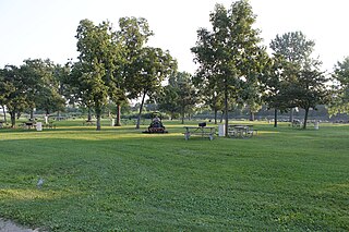
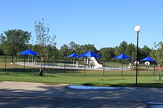
Lower Huron Metropark is a park in the Huron-Clinton system of metro parks in Metro Detroit. The park covers 1,258 acres (5.09 km2) along the Huron River and has hike-bike trails and two self-guided nature trails. In the winter, the park has cross-country skiing. The park also has a water slide amusement facility, the Turtle Cove Family Aquatic Center. There is a 27-site campground, a group campground and canoe camping in the park.
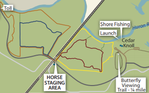
Lake Erie Metropark is a park in the Huron-Clinton system of metro parks. The park is a 1,607-acre (6.50 km2) recreational facility located between the mouth of the Huron River on Lake Erie to the south and the City of Gibraltar to the north, and consists of natural marshes and ponds, hike and bike trails, nature trails, a marina, and a boat launch. The park also has a wave action swimming pool, an 18-hole regulation golf course, and the Marshlands Museum and Nature Center. It has a three-mile (5 km) shoreline along Lake Erie and is a popu bird-watching site. The children's play area, located near the Wave Pool, previously consisted of a child-size city before being reconstructed into a modernized playground.
Willow Metropark is a park in the Huron-Clinton Metroparks system, located on the banks of the Huron River between Lower Huron Metropark to the northwest and Oakwoods Metropark to the southeast. The park consists of a wide variety of trails and recreational areas, including an 18-hole golf course, the 17-acre (69,000 m2) Washago Pond, hike/bike trails, a disc golf course,a children's play area, a pool, and a kayak/canoe launch, in addition to groomed cross country ski trails in the winter months.
The Border-to-Border (B2B) Trail is a partially constructed non-motorized trail in Washtenaw County, Michigan. The trail is planned to cover approximately 35 miles (56 km) from Livingston County to Wayne County along the Huron River.

This is a list of trails and greenways in Detroit.

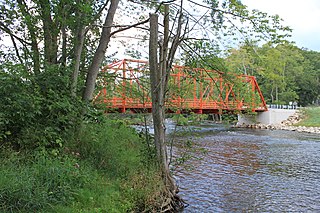
The Flat Rock Dam is a decommissioned hydroelectric gravity dam crossing the Huron River. It is located in the city of Flat Rock in Wayne County in the U.S. state of Michigan. The dam was built by the Ford Motor Company in 1924 for hydroelectricity for the nearby Ford Motor Company Lamp Factory, which remained in operation until 1950.

The Superior Dam is a hydroelectric barrage dam crossing the Huron River. It is located in Superior Township in Washtenaw County in the U.S. state of Michigan. It was completed in 1920 and currently provides hydroelectricity to the nearby city of Ann Arbor, which owns and maintains the dam and power station.