The Kwahu Plateau is a 260 km (160 mi) long plateau in southern Ghana. It consists of the uplifted southern edge of the Volta River Basin. It forms the main watershed of Ghana, separating rivers in the Volta River system from rivers in the western half of Ghana which flows into the Atlantic Ocean. The plateau has an average elevation of 1,500 feet and its highest point is Mount Akmawa at 2,586 feet. The plateau is dissected by several valleys and is marked by towering peaks. To the south it borders dense forest country, which it shields from the harmattan winds of the interior. Cacao cultivation has been introduced in the west, through which traditional trade routes lead to the Atlantic; vegetable cultivation is stressed in the eastern sector. The largest and most important towns on the Kwahu Plateau are Wenchi, Mampong, Mpraeso, and Abetifi.

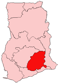
The Eastern Region is located in south Ghana and is one of the sixteen administrative regions of Ghana. Eastern region is bordered to the east by the Lake Volta, to the north by Bono East Region and Ashanti region, to the west by Ashanti region, to the south by Central region and Greater Accra Region. Akans are the dominant inhabitants and natives of Eastern region and Akan, Ewe, Krobo, Hausa and English are the main spoken languages. The capital town of Eastern Region is Koforidua.The Eastern region is the location of the Akosombo dam and the economy of the Eastern region is dominated by its high-capacity electricity generation. Eastern region covers an area of 19,323 square kilometres, which is about 8.1% of Ghana's total landform.

Donkorkrom is a town in south Ghana and is the capital of Kwahu Afram Plains North district, a district in the Eastern Region of Ghana.

Kwahu refers to an area and group of people that live in Ghana and are part of the Twi-speaking Akan group. The area has been dubbed Asaase Aban, or the Natural Fortress, in view of its position as the highest habitable elevation in the country. Kwahu lies in the Eastern Region of Ghana, on the west shore of Lake Volta. The Kwahus share the Eastern Region with their fellow Akans: the Akyem and Akuapem, as well as the Adangbe-Krobos. A significant migrant population from the Northern and Volta Regions and some indigenous Guans from the bordering Oti and Brong East Regions live in the Afram Plains area. They work as traders, farm-hands, fisherfolk, and caretakers in the fertile waterfront 'melting pot'.

Nkawkaw is a town in southern Ghana and is the capital of Kwahu East District, an area in the Eastern Region of south Ghana. Nkawkaw has a 2013 settlement population of 61,785 people. Nkawkaw is also described as a city in a valley as it the gateway to ascend the Kwahu mountains

Afram Plains District is a former district that was located in Eastern Region, Ghana. Originally created as an ordinary district assembly in 1988 when it was known as Kwahu North District, which was created from the former Kwahu District Council, until it was later renamed to become Afram Plains District in 1993. However on 19 June 2012, it was split off into two new districts: Kwahu Afram Plains North District and Kwahu Afram Plains South District. The district assembly was located in the northern part of Eastern Region and had Donkorkrom as its capital town.

Kwahu South District is one of the thirty-three districts in Eastern Region, Ghana. Originally created as an ordinary district assembly in 1988, which was created from the former Kwahu District Council. Later, the southwest part of the district was split off to create Kwahu West District in August 2004 ; thus the remaining part has been retained as Kwahu South District. Then the northwest part of the district was split off to create Kwahu East District on 29 February 2008; thus the remaining part has been still retained as Kwahu South District. The district assembly is located in the western part of Eastern Region and has Mpraeso as its capital town.

Kwahu East District is one of the thirty-three districts in Eastern Region, Ghana. Originally it was formerly part of the then-larger Kwahu South District in 1988, which was created from the former Kwahu District Council, until the northwest part of the district was split off to create Kwahu East District on 29 February 2008. The district assembly is located in the western part of Eastern Region and has Abetifi as its capital town.
Mpraeso is a town and the capital of Kwahu South district, a district in the Eastern Region of south Ghana, located at an altitude of 367 m on the Kwahu Plateau, which forms the south-west boundary of Lake Volta. Mpraeso has a 2013 settlement population of 11,190 people.
Pepease is the second largest town in the Kwahu East District, in the Eastern Region of Ghana.

Kwahu Afram Plains North District is one of the thirty-three districts in Eastern Region, Ghana. Originally it was formerly part of the then-larger Kwahu North District in 1988, until the western part of the district was split off to create Kwahu Afram Plains South District on 19 June 2012; thus the remaining part has been renamed as Kwahu Afram Plains North District. The district assembly is located in the northern part of Eastern Region and has Donkorkrom as its capital town.

Kwahu West Municipal District is one of the thirty-three districts in Eastern Region, Ghana. Originally it was formerly part of the then-larger Kwahu South District in 1988, which was created from the former Kwahu District Council, until the southwest part of the district was split off to create Kwahu West District in August 2004; which it later was elevated to municipal district assembly status on 1 July 2007 to become Kwahu West Municipal District. The municipality is located in the western part of Eastern Region and has Nkawkaw as its capital town.

Afram Plains is in the Eastern region of Ghana and is divided into Kwahu Afram Plains North and Kwahu Afram Plains South Constituencies. The current member of Parliament for the Kwahu Afram Plains North constituency is Betty Nana Efua Krosby Mensah. She succeeded Emmanuel Aboagye Didieye. Joseph Appiah Boateng is also the current Member of Parliament for the Kwahu Afram Plains South.
Nkwatia Kwahu is a town in the Kwahu East district, a district in the Eastern Region of south Ghana. It is also the home of the St.Peter's Boys Secondary School and also Nkwatia Presbyterian Secondary School.

Abetifi is a small town in south Ghana and is the capital of Kwahu East district, a district in the Eastern Region of south Ghana.
Bepong is a major town in Kwahu South district, in Eastern Ghana.
Obomeng is a small town in the Kwahu mountains in the Eastern Region (Ghana) in West Africa.
Kwahu Easter is the annual Easter celebrations at the Kwahu South District of the Eastern Region of Ghana. People from all walks of life and all nationality throng to the Kwahu Hills every Easter to celebrate the three-day-long holiday.

Kwahu Afram Plains South District is one of the thirty-three districts in Eastern Region, Ghana. Originally it was formerly part of the then-larger Kwahu North District in 1988, until the western part of the district was split off to create Kwahu Afram Plains South District on 19 June 2012; thus the remaining part has been renamed as Kwahu Afram Plains North District. The district assembly is located in the northern part of Eastern Region and has Tease as its capital town.

Kwahu District is a former district council that was located in Eastern Region, Ghana. Originally created as an ordinary district assembly in 1975. However, on 10 March 1989, it was split off into two new district assemblies: Kwahu South District and Kwahu North District. The district assembly was located in the northern part of Eastern Region and had Mpraeso as its capital town.


