
Bedford is a town in Middlesex County, Massachusetts, United States. The population of Bedford was 14,161 at the 2022 United States census.

Billerica is a town in Middlesex County, Massachusetts, United States. The population was 42,119 according to the 2020 census. It takes its name from the town of Billericay in Essex, England.

North Billerica is an unincorporated village of the town of Billerica, Massachusetts, United States, one of the nine sections (hamlets) that make up the Town of Billerica. It is the home to Faulkner and Talbot mills and the North Billerica Train Depot. The Middlesex Canal was built through the village in 1783 and the Boston and Lowell Railroad was put through in the 1840s.

The Middlesex Turnpike was an early turnpike between Cambridge and Tyngsborough, Massachusetts and the New Hampshire border, where it connected with the Amherst Turnpike and thence Nashua and Claremont, New Hampshire.

The Chelmsford Center Historic District is a historic district encompassing the historic heart of the town of Chelmsford, Massachusetts. It extends from the town's central square in the east, where the intersection of Billerica Road and Chelmsford Street is located, west beyond the junction of Littleton and North Roads with Westford Street, and from there north along Worthen Road. It includes the area that was the 17th-century heart of the town, including its common and first burying ground, and has been the town's civic heart since its founding.
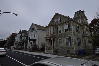
The North Bedford Historic District is a historic district roughly bounded by Summer, Parker, Pleasant and Kempton Streets in New Bedford, Massachusetts. It encompasses a predominantly residential neighborhood north of downtown New Bedford which was developed primarily in the mid 19th-century. It features a variety of worker housing of the period, as well as a number of higher quality houses built by businessmen. The district was added to the National Register of Historic Places in 1979.

The Acushnet Heights Historic District is a predominantly residential historic district in central New Bedford, Massachusetts. It encompasses a densely-built urban area about 20 acres (8.1 ha) in size, which was developed as a working-class area, beginning in the 1860s, for the many workers in the city's factories. The district was listed on the National Register of Historic Places in 1989. It abuts the North Bedford Historic District, which is just to the south, and includes the following separately-listed properties: the Union Street Railway Carbarn, the Bradford Smith Building, and the Dawson Building.

The Russells Mills Village Historic District is a historic district on Russells Mills, Rock O' Dundee, Slades Corner, Horseneck and Fisher Roads in Dartmouth, Massachusetts. It encompasses an area that was an early industrial center, flourishing from the 18th century into the early 19th century. The district was added to the National Register of Historic Places in 1985.

The Bedford Center Historic District encompasses the historic heart of the town of Bedford, Massachusetts. It extends along Great Road between Bacon and Concord Roads, and includes primarily residential areas on adjacent side streets. The area includes the town's main civic buildings, its first cemetery, and a diverse array of residential architecture spanning more than two centuries. The district was listed on the National Register of Historic Places in 1977; its boundaries were adjusted in 2014 and its period of significance extended.

Bedford Depot is a historic railroad depot in Bedford, Massachusetts, United States. Bedford was the junction of the Reformatory Branch and the Lexington Branch of the Boston and Maine Railroad; it saw passenger service until 1977 as the stub of the Lexington Branch. The original 1874 depot and 1877 freight house are listed on the National Register of Historic Places; along with a restored Budd Rail Diesel Car, they form the centerpieces of the Bedford Depot Park.
The Billerica Mills Historic District is a historic district between the Concord River, Treble Cove Terrace, Kohlrausch Avenue, Indian Road, Holt Ruggles, and Rogers Streets in the village of North Billerica, Massachusetts.

The Billerica Town Common District is a historic district encompassing what remains of the 1655 town common of Billerica, Massachusetts, and the properties surrounding it. The district is roughly bounded by Cummings Street, Concord Road, and Boston Road. It includes the site of the town's first meeting house, and a variety of predominantly 19th-century structures, including two churches and the town hall.

The Wilson Mill—Old Burlington Road District encompasses a historic mill site and several adjacent historic houses in Bedford, Massachusetts. It is located southwest of the junction of Massachusetts Route 62 and United States Route 3, and includes a mill pond and dam, a stone-lined stream channel, foundations of a 17th-century gristmill, two bridges, and three houses. The mill site is located just off Old Burlington Road, west of its crossing of Vine Brook. Just south of Old Burlington Road lies the mill pond and dam. The oldest of the three houses in the district is the Bacon-Gleason-Blodgett Homestead, built c. 1740 and home to several of the mill's owners. The other two houses, at 130 and 138 Old Burlington Road, were built around the turn of the 20th century, and are associated with the Hunt family, longtime landowners in the area.
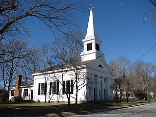
The Lincoln Center Historic District is a historic district on Bedford, Lincoln, Old Lexington, Sandy Pond, Trapelo & Weston Roads in Lincoln, Massachusetts. The district encompasses Lincoln's civic heart, consisting of a traditional New England Meeting House, a Late Victorian church and the Lincoln Public Library, and a Georgian Revival town hall, as well as a cluster of residences dating to the mid-18th century, when Lincoln was established as a town separate from its neighbors.
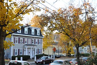
The Washington Square Historic District of Lowell, Massachusetts encompasses a historic subdivision laid out in 1832. The focal point of the subdivision is Kittridge Park, which lies on the eastern side of the district and was an original part of the subdivision plan developed by the Nesmith Brothers. It was the first significant residential subdivision in the city aimed at a wealthier clientele, and was designed by landscape architect Alexander Wadsworth. The district was added to the National Register of Historic Places in 1982, and expanded slightly in 1999.

The Old Chestnut Hill Historic District encompasses the historic residential heart of the Newton portion of Chestnut Hill, Massachusetts. When first listed on the National Register of Historic Places in 1986, the district extended along Hammond Street, between Beacon Street and the MBTA Green Line right-of-way, and along Chestnut Hill Road between Hammond and Essex, including properties along a few adjacent streets. The district was expanded in 1990 to include more of Chestnut Hill Road and Essex Road, Suffolk Road and the roads between it and Hammond, and a small section south of the Green Line including properties on Hammond Street, Longwood Road, and Middlesex Road. A further expansion in 1999 added a single property on Suffolk Road.

The Amherst Village Historic District encompasses the historic village center of Amherst, New Hampshire. Centered on the town's common, which was established about 1755, Amherst Village is one of the best examples of a late-18th to early-19th century New England village center. It is roughly bounded on the north by Foundry Street and on the south by Amherst Street, although it extends along some roads beyond both. The western boundary is roughly Davis Lane, the eastern is Mack Hill Road, Old Manchester Road, and Court House Road. The district includes the Congregational Church, built c. 1771-74, and is predominantly residential, with a large number of Georgian, Federal, and Greek Revival houses. Other notable non-residential buildings include the Farmer's Bank, a Federal-style brick building built in 1806, and the Amherst Brick School, a brick Greek Revival structure that has served as the School Administrative Unit 39 offices since 1997.

The Bedford Veterans Affairs Medical Center, also known as the Edith Nourse Rogers Memorial Veterans Hospital, is a medical facility of the United States Department of Veterans Affairs (VA) at 200 Springs Road in Bedford, Massachusetts. Its campus once consisted of about 276 acres (112 ha) of land, which had by 2012 been reduced to 179 acres (72 ha). The hospital was opened in 1928 to treat neuropsychiatric patients, but now provides a wider array of medical services. Through the efforts of Congresswoman Edith Nourse Rogers, the center was expanded to offer services to women in 1947; her role led to the center being renamed in her honor by President Jimmy Carter.
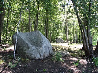
The Two Brothers Rocks–Dudley Road Historic District encompasses a historically significant rural area of Bedford and Billerica, Massachusetts. The district covers 230 acres (93 ha) of predominantly rural and residential property, along Dudley Street, a narrow, winding road that was laid out in colonial days. It also includes a significant amount of conservation land, including local, state, and federal lands. The federal lands of the Great Meadows National Wildlife Refuge which line the banks of the Concord River, include the "Two Brothers Rocks", which were used to mark a land boundary between grants given to early Massachusetts Bay Colony governors John Winthrop and Thomas Dudley, and which featured as boundary markers into the 20th century.

The Head of the River Historic District is a historic district encompassing a village area at the head of navigation of the Acushnet River, which separates Acushnet and New Bedford, Massachusetts. The village is centered at the junction of Tarkin Hill Road, River Road, and Mill Road in New Bedford, and Main Street in Acushnet. The area went through two significant periods of development: the first was in the late 18th and early 19th century, and the second was in the early 20th century. The district was listed on the National Register of Historic Places in 2009.


