
Harvard Yard, in Cambridge, Massachusetts, is the oldest part of the Harvard University campus, its historic center and modern crossroads. It contains most of the freshman dormitories, Harvard's most important libraries, Memorial Church, several classroom and departmental buildings, and the offices of senior University officials including the President of Harvard University.

Harvard Square is a triangular plaza at the intersection of Massachusetts Avenue, Brattle Street and John F. Kennedy Street near the center of Cambridge, Massachusetts, United States. The term "Harvard Square" is also used to delineate the business district and Harvard University surrounding that intersection, which is the historic center of Cambridge. Adjacent to Harvard Yard, the historic heart of Harvard University, the Square functions as a commercial center for Harvard students, as well as residents of western Cambridge, the western and northern neighborhoods and the inner suburbs of Boston. The Square is served by Harvard station, a major MBTA Red Line subway and a bus transportation hub.

Central Square is an area in Cambridge, Massachusetts centered on the junction of Massachusetts Avenue, Prospect Street and Western Avenue. Lafayette Square, formed by the junction of Massachusetts Avenue, Columbia Street, Sidney Street and Main Street, is also considered a part of the Central Square area. Harvard Square is to the northwest along Massachusetts Avenue, Inman Square is to the north along Prospect Street and Kendall Square is to the east along Main Street. The section of Central Square along Massachusetts Avenue between Clinton Street and Main Street is designated the Central Square Historic District, and was added to the National Register of Historic Places in 1990.

The Old Ship Church is a Puritan church built in 1681 in Hingham, Massachusetts. It is the only surviving 17th-century Puritan meetinghouse in the United States. Its congregation, gathered in 1635 and officially known as First Parish in Hingham, occupies the oldest church building in continuous ecclesiastical use in the country. On October 9, 1960, it was designated a National Historic Landmark, and on November 15, 1966, it was added to the National Register of Historic Places.
The Port, formerly Area 4, is a neighborhood of Cambridge, Massachusetts, roughly between Central Square, Inman Square, and MIT. It is bounded on the south by Massachusetts Avenue, on the west by Prospect Street, on the north by Hampshire Street, and on the east by the Grand Junction Railroad tracks. Area 4 is a densely populated residential neighborhood with about 7,000 residents.

The Margaret Fuller House was the birthplace and childhood home of American transcendentalist Margaret Fuller (1810–1850). It is located at 71 Cherry Street, in the Old Cambridgeport Historic District area of Cambridge, Massachusetts, in the neighborhood now called "The Port". The house is now a National Historic Landmark.

The West Newton Village Center Historic District encompasses the heart of the village of West Newton, in the city of Newton, Massachusetts in the United States. It extends along Washington Street between Lucas Court in the west and Davis Court in the east, and includes a few properties on immediately adjacent side streets, including Watertown Street and Waltham Street. The village is the second-largest of Newton's commercial centers and is the best-preserved of its late 19th and early 20th century village centers. The district was listed on the National Register of Historic Places in 1990.
The First Unitarian Universalist Society in Newton occupies a prominent location at 1326 Washington Street in the heart of the village of West Newton in Newton, Massachusetts. Architect Ralph Adams Cram designed the church, Frederick Law Olmsted Jr. designed the grounds, the cornerstone was laid in 1905, and it was dedicated in 1906; it is one of the village's oldest buildings. The church is in Cram's signature Gothic Revival style, with buttressed walls and a blocky square tower with crenellations and spires. An enclosed courtyard is formed by an office wing, banquet hall, and parish house, which are built to resemble Elizabethan architecture with brick first floor and half-timbered upper level.
The Ash Street Historic District Cambridge, Massachusetts is a residential historic district on Ash Street and Ash Street Place between Brattle and Mount Auburn Streets in Cambridge, Massachusetts, off Brattle Street just west of Harvard Square. The district consists of ten well-preserved houses, most of which were built between 1850 and 1890. The district was listed on the National Register of Historic Places in 1982.

The B B Chemical Company is an historic office and industrial building at 784 Memorial Drive in Cambridge, Massachusetts. It was built in 1937 for the Boston Blacking Company, an adhesive manufacturer whose most famous brand name was Bostik, to a design by Coolidge, Shepley, Bulfinch & Abbott, and is a prominent local example of Streamline Moderne architecture. From 1979 to 1996, it served as the headquarters of the Polaroid Corporation. The building was added to the National Register of Historic Places in 1982 under the incorrect name "B and B Chemical Company". It is now owned by The Bulfinch Companies of Needham, Massachusetts.

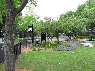
The Cambridge Common Historic District is a historic district encompassing one of the oldest parts of Cambridge, Massachusetts. It is centered on the Cambridge Common, which was a center of civic activity in Cambridge after its founding in 1631. It was the site of the election for governor of the Massachusetts Bay Colony in 1636, and was a military barracks site during the American Revolutionary War. The common was gradually reduced in size to its present roughly triangular shape, and surrounded by buildings in the 18th and 19th centuries. In 1973 a historic district encompassing the extant common and everything within 100 feet (30 m) of it was listed on the National Register of Historic Places. In 1987 the district was amended to rationalize the boundary, which overlapped adjacent districts and included portions of some buildings.
The Asa Ellis House is a historic house located at 158 Auburn Street, Cambridge, Massachusetts.

Fort Washington, also known as Fort Washington Park, is a historic site at 95 Waverly Street in Cambridge, Massachusetts. It was built by soldiers of the Continental Army under the orders of George Washington in November 1775. It is the oldest surviving fortification from the American Revolutionary War and the only surviving fortification from the Siege of Boston. Fort Washington was placed on the List of Registered Historic Places in Massachusetts on April 3, 1973.

The Harvard Street Historic District is a historic district on Harvard Street between Ellery and Hancock Streets in Cambridge, Massachusetts. It includes houses on both sides of the street, numbered from 335 to 344 inclusive, an area that marks the summit of Dana Hill. Harvard Street was laid out as a direct route from "Old Cambridge" to Boston in the early 1800s, and was run over Dana Hill over the objection of Judge Francis Dana, whose estate sat on top of the hill. The street was developed over the 19th century with a succession of high-quality houses.

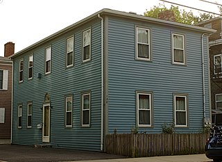
The Andrew Newman House is a historic house in Cambridge, Massachusetts. It is a 1+1⁄2-story wood-frame structure, five bays wide, with a central chimney and an entrance sheltered by an enclosed vestibule. Built in 1823, this single story wood-frame house is one of the oldest houses in the Cambridgeport area of the city. The house is also unusual for its construction date, since it is a Georgian style Cape house, as opposed to the then-prevalent Federal style. Its first owner was a ropemaker.

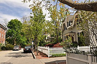
The Old Cambridge Historic District is a historic district encompassing a residential neighborhood of Cambridge, Massachusetts that dates to colonial times. It is located just west of Harvard Square, and includes all of the properties on Brattle Street west of Mason Street to Fresh Pond Parkway, all of the properties on Mason Street and Elmwood Avenue, and nearby properties on Craigie Street. The district includes five National Historic Landmarks: Elmwood, the Reginald A. Daly House, the Oliver Hastings House, the Mary Fiske Stoughton House, and the Longfellow House–Washington's Headquarters National Historic Site, as well as several other houses listed separately on the National Register. The district follows the general route of the Watertown Path, an early colonial road that supposedly followed a Native American trail. This portion of the way became known as Tory Row during the American Revolution, because many of the fine mansions lining it were owned by Loyalists. In the 19th and early 20th centuries it continued by a fashionable location, and now features a number of architecturally significant buildings. It includes 215 contributing buildings and one other contributing sites over an area of 52 acres (21 ha). One included building is the Cambridge Historical Society's offices, which are in the NRHP-listed Hooper-Lee Nichols House, located at 159 Brattle Street.

The Valentine Soap Workers Cottages are a pair of adjacent historic houses in Cambridge, Massachusetts, that are listed on the National Register of Historic Places.

The Salem–Auburn Streets Historic District is a residential historic district at Salem and Auburn Streets in Cambridge, Massachusetts. The district includes a collection of houses that is among the oldest in the Cambridgeport section of the city, and includes most of the houses on two blocks of these streets. The district was added to the National Register of Historic Places in 1982.

The Lower Highlands Historic District encompasses one of the oldest residential areas of Fall River, Massachusetts. The district is roughly bounded by Cherry, Main, Winter, and Bank Streets, and is located just east of the Downtown Fall River Historic District and directly south of the Highlands Historic District. This area was settled by 1810, has architecture tracing the city's growth as a major industrial center. The historic district was added to the National Register of Historic Places in 1984.

Brattle Street in Cambridge, Massachusetts, called the "King's Highway" or "Tory Row" before the American Revolutionary War, is the site of many buildings of historical interest, including the modernist glass-and-concrete building that housed the Design Research store, and a Georgian mansion where George Washington and Henry Wadsworth Longfellow both lived, as well as John Vassall and his seven slaves including Darby Vassall. Samuel Atkins Eliot, writing in 1913 about the seven Colonial mansions of Brattle Street's "Tory Row," called the area "not only one of the most beautiful but also one of the most historic streets in America." "As a fashionable address it is doubtful if any other residential street in this country has enjoyed such long and uninterrupted prestige."


