
Bellows Falls is an incorporated village located in the town of Rockingham in Windham County, Vermont, United States. The population was 3,148 at the 2010 census. Bellows Falls is home to the Green Mountain Railroad, a heritage railroad; the annual Roots on the River Festival; and the No Film Film Festival.
Chatham is a town in Columbia County, New York, United States. The population was 4,128 at the 2010 census.

This is a list of properties and districts in Massachusetts listed on the National Register of Historic Places. There are over 4,300 listings in the state, representing about 5% of all NRHP listings nationwide and the second-most of any U.S. state, behind only New York. Listings appear in all 14 Massachusetts counties.

19th Century Willowbrook Village was an open-air museum encompassing a former 19th-century village in Newfield, Maine. It is located north of the town center on Elm Street, on approximately 10 acres (4.0 ha), with 34 buildings. It was open 10 a.m. to 5 p.m., 5 days each week from the Saturday of Memorial Day weekend through October, closed Tuesdays and Wednesdays. Much of the museum property is listed on the National Register of Historic Places as the Newfield (Willowbrook) Historic District.

North Billerica is an unincorporated village of the town of Billerica, Massachusetts, United States, one of the nine sections (hamlets) that make up the Town of Billerica. It is the home to Faulkner and Talbot mills and the North Billerica Train Depot. The Middlesex Canal was built through the village in 1783 and the Boston and Lowell Railroad was put through in the 1840s.

Ironstone is an historic village,, in the township of Uxbridge, Massachusetts, United States. It derived its name from plentiful bog iron found here which helped Uxbridge to become a center for three iron forges in the town's earliest settlement. South Uxbridge has historic sites, picturesque weddings, hospitality, industrial and distribution centers, and the new Uxbridge High School. This community borders North Smithfield, and Burrillville, Rhode Island, and Millville, Massachusetts. South Uxbridge receives municipal services from Uxbridge, for fire, police, EMS, School district, public works, and other services. There is a South Uxbridge fire station of the Uxbridge fire department. Worcester's Judicial District includes Uxbridge District Court. Ironstone appears on the Blackstone U.S. Geological Survey Map. Worcester County is in the Eastern time zone and observes DST.

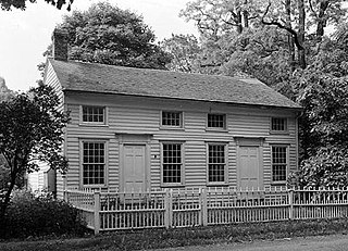
The Seth Aldrich House or S. Aldrich House is an historic house located at 317 Aldrich Street, in Uxbridge, Massachusetts. On October 7, 1983, it was added to the National Register of Historic Places.

Saylesville is a village and historic district in Lincoln, Rhode Island.

The Chatham Windmill is a historic windmill at Chase Park in Chatham, Massachusetts. Built in 1797, it is one of the state's few surviving wooden windmills, and also one of the few still in working condition. The windmill was listed on the National Register of Historic Places in 1978.

The Talcottville Historic District is a historic district in the town of Vernon, Connecticut. Centered on Elm Hill Road and Main Street, it encompasses a 19th-century mill village, including archaeological remnants of very early cotton-spinning facilities, and old stone dam, and a major wood-frame mill constructed by the Talcott brothers. Also included in the village are a significant number of mill worker housing units, many dating to the middle decades of the 19th century, and an 1891 lenticular pony truss bridge, built by the Berlin Iron Bridge Company. The district was listed on the National Register of Historic Places in 1989.

The Baxter Mill is a historic gristmill on Massachusetts Route 28 in West Yarmouth, Massachusetts. Built about 1710 and restored to working order in 1961, it is the only surviving 18th-century water-powered mill on Cape Cod. It is now a museum property owned by the town and operated by the Yarmouth Historical Commission. The mill was listed on the National Register of Historic Places in 1981.

The Brewster Old King's Highway Historic District is a historic district encompassing much of Massachusetts Route 6A and portions of some adjacent roads in Brewster, Massachusetts, which was known as the Old King's Highway during colonial times. The center of Brewster grew around the junction of the Old King's Highway and Harwich Road, with its first church built there in 1700, and a nearby burying ground established in 1707. The civic and commercial functions of the town were spread along the Old King's Highway through the 19th and into the early 20th century. This concentration of historic resources extends about 1.5 miles (2.4 km) west of the main junction, and about 1.2 miles (1.9 km) eastward.

The Town Hall Square Historic District is a historic district encompassing the center of Sandwich, Massachusetts. The original 54-acre (22 ha) district was visually centered on Sandwich Town Hall, Shawme Pond, and the reconstructed Dexter Grist Mill. When first listed on the National Register of Historic Places in 1975, it was roughly bounded by Main, Grove, Water Sts., and Tupper Rd. from Beale Ave. to MA 6A. In 2010 the district was expanded, adding another 170 acres (69 ha) and more than 150 contributing resources.
The Amesbury and Salisbury Mills Village Historic District is a historic district on Market Sq. roughly bounded by Boardman, Water, Main and Pond Streets in Amesbury, Massachusetts. It was the site of significant industrial development between 1800 and 1875, during which time the town developed a significant textile processing industry. Among the buildings in the district is the Salisbury Mill #4, a four-story brick Greek Revival building which features dentil decorations on its eaves and towers.

The Sheffield Plain Historic District encompassing the original 18th-century village center of Sheffield, Massachusetts, United States. The linear district extends southward about 0.5 miles (0.80 km) from the junction of United States Route 7 and Cook Road, where the original town common is located. The district was primarily developed in the mid-18th and early 19th centuries. It was listed on the National Register of Historic Places in 1988.

The Ware Millyard Historic District encompasses a 19th-century mill complex and industrial mill village in the town of Ware, Massachusetts. It is roughly bounded by South Street, the Ware River, Upper Dam Complex, Park Street, Otis Avenue and Church Street. The area includes surviving mill buildings, the oldest of which date to the 1840s, and a collection of tenement-style housing built for the millworkers, built between 1845 and the 1880s. The district was listed on the National Register of Historic Places in 1986.

The Main Street Historic District of Easthampton, Massachusetts encompasses the historic heart of the town, running along Main Street between Northampton and Center Streets. The area has been the civic and economic heart of the town since incorporation in 1785. Most of the commercial buildings date from the 1840s to the 1880s, and are built in an Italianate style. The housing stock of the district also includes Italianate styling, but there are also a number of Greek Revival structures. The major civic structures of the town are in the district, including the town hall, public library, and the First Congregational Church, which is the second for the congregation, a brick Romanesque Revival building dating to 1851. The district was added to the National Register of Historic Places in 1986.

The Andover Village Industrial District encompasses one of the 19th century industrial mill villages of Andover, Massachusetts known locally as "The Village". The growth of this village contributed to the decision in the 19th century to separate the more rural area of North Andover from the town. It is centered on a stretch of the Shawsheen River between North Main Street on the east and Moraine Street on the west. Most of the district's properties lie on Stevens Street, Red Spring Road, Shawsheen Road, and Essex Street, with a few properties also located on adjacent roads.

The Forge Village Historic District of Westford, Massachusetts encompasses one of the town's historic 19th century mill villages. The focal point of the district is the mill complex of the Abbot Worsted Company, around which the village expanded after its founding in 1854. Prior to its founding the area was the site of a number of blacksmithies and iron forging operations, and was the site of a fulling mill in the 18th century. The center of the district is at the junction of East and West Prescott Streets with Pleasant Street, radiating away to ballfields on West Prescott, Abbot Street at Pleasant, and just beyond Orchard Street on East Prescott. Worker housing occupies a number of adjacent streets in the area.

The Hadlyme North Historic District is an 81-acre (33 ha) historic district located in the southwest corner of the town of East Haddam, Connecticut. It represents the historic core of the village of Hadlyme, which straddles the town line, and consists primarily of two north-south roads, Town Street. The village arose around a church society founded in 1743, and grew with the development of small industries along area waterways. It was listed on the National Register of Historic Places in 1988.


