
Ifẹ̀ is an ancient Yoruba city in south-western Nigeria, founded in the 6th century. The city is located in present-day Osun State. Ifẹ̀ is about 218 kilometers northeast of Lagos with a population of over 500,000 people, which is the highest in Osun State according to population census of 2006.

Osogbo is a city in Nigeria. It became the capital city of Osun State in 1991. Osogbo city seats the Headquarters of both Osogbo Local Government Area and Olorunda Local Government Area. It is some 88 kilometers by road northeast of Ibadan. It is also 108 kilometres (67 mi) by road south of Ilorin and 108 kilometres (67 mi) northwest of Akure. Osogbo shares boundaries with Ikirun, Ilesa, Ede, Egbedore, Ogbomosho and Iragbiji and it is easily accessible from any part of the state because of its central nature. It is about 48 km from Ife, 32 km from Ilesa, 46 km from Iwo, 48 km from Ikire and 46 km from Ila-Orangun; the city had a population of about 200,000 people and an approximate land area of 126 km. The postal code of the area is 230.
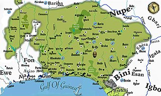
Yorubaland is the homeland and cultural region of the Yoruba people in West Africa. It spans the modern-day countries of Nigeria, Togo and Benin, and covers a total land area of 142,114 km2 (54,871 sq mi). Of this land area, 106,016 km2 (74.6%) lies within Nigeria, 18.9% in Benin, and the remaining 6.5% is in Togo. Prior to European colonization, a portion of this area was known as Yoruba country. The geo-cultural space contains an estimated 55 million people, the majority of this population being ethnic Yoruba.

Osun State, occasionally known as the State of Osun by the state government, is a state in southwestern Nigeria; bounded to the east by Ekiti and Ondo states for 84 km and for 78 km respectively, to the north by Kwara State for 73 km, to the south by Ogun State for 84 km and to the west by Oyo State, mostly across the River Osun. Named for the River Osun—a vital river which flows through the state—the state was formed from the southeast of Oyo State on 27 August 1991 and has its capital as the city of Osogbo.
The Ìgbómìnà are a subgroup of the Yoruba ethnic group, which originates from the north central and southwest Nigeria. They speak a dialect called Ìgbómìnà or Igbonna, classified among the Central Yoruba of the three major Yoruba dialectical areas. The Ìgbómìnà spread across what is now southern Kwara State and northern Osun State. Peripheral areas of the dialectical region have some similarities to the adjoining Ekiti, Ijesha and Oyo dialects. Idoba is on Owode Ofaro Land
Orangun or Ọ̀ràngún of Ìlá is the title of the paramount ruler of one of the ancient Igbomina kingdoms, a sub group of the Yoruba people with its seat and capital located in Ila Orangun, central Yorubaland, presently in southwestern Nigeria.
Oba-Igbomina, is an ancient Igbomina town in northeastern Isin Local Government Area of Kwara State. It is one of the five related Yoruba towns named "Oba", the others being
Ìsèdó is an ancient Igbomina kingdom in northeastern Yorubaland of Nigeria. Ìsẹ̀dó was founded as a new city-state several centuries ago by Ọba'lumọ, a Prince of the ancient Oba civilization. Ìsẹ̀dó is fully known and called "Ìsẹ̀dó-Olúmọ̀" using its founder-king's name as an identifier suffix. Ọba'lumọ, emigrated from the ancient Ọ̀bà civilization in northeastern Yorubaland.
Offa is a city in Kwara State of Nigeria, with a population of about 166,112 inhabitants. The town is noted for its weaving and dyeing trade, using vegetable dyes made from locally grown indigo and other plants. Offa is well known for the cultivation of sweet potatoes and maize which also formed part of the favourite staple foods for the indigenes in the town. Cattle, goats and sheep are also raised there. The main religions practiced in the town are Islam, Christianity and traditional religions.
Irepodun is a Local Government Area in Kwara State, Nigeria. Its headquarters is in the town of Omu-Aran. The local government is located on 8.5381º N, 5.1431º E.
Isin is a Local Government Area in Kwara State, Nigeria. Isin Local Government Area of Kwara State was created from the old Irepodun Local Government Area in 1996 with the headquarters at Owu-Isin. It has an area of 633 km2 and a population of 59,738 at the 2006 census.
Oke Ero is a Local Government Area in Kwara State, Nigeria. Its headquarters are in the town of Iloffa. Other Major towns in Oke Ero are Odo-Owa, Idofin, Ekan Nla, Ayedun, Erin Mope, Egosi, Imode, Idofin Odo-Ase, Kajola and Ilale. The first executive chairman of Oke-Ero is the late Otunba Moses Afolayan, while the second was Barrister Kayode Towoju.
Ileogbo is the headquarters of Aiyedire Local Government in Osun State, Nigeria. It is situated midway between Ibadan and Osogbo, the capitals of Oyo and Osun State. Ibadan is about 44 km to the south of Ileogbo while Osogbo is about 42 km to its north, Oyo 40 km to its west, while Gbongan and Ife are located to the east of the town.
Omupo or Omu-ipo is an ancient Igbomina-Yoruba town situated in the southeastern part of Kwara State. It is one of the prominent towns in Ifelodun Local Government Area of the State. It is the headquarters of 34 communities of Omupo District, the headquarters of Omupo/Idofian Area Council of Ifelodun Local Government. Omupo Constituency was also created in 1979 for a representative to the Kwara State House of Assembly.
Isanlu Isin or Isanlusin is an ancient town in Isin LGA of Kwara State, Nigeria. Isin LGA of Kwara State was created from the old Irepodun Local Government Area in 1996 with the headquarters at Owu-Isin. Notable towns in Isin are Isanlu Isin, Ijara Isin, Owu Isin, Iwo, Oke-Aba, Oke-Onigbin, Alla, Edidi, Odo-Eku, Oba, Iji, Pamo, Oponda, Igbesi, Eleyin, Kudu-Owode, to mention but few. Collectively, these towns are today located in Isin Local Government area of Kwara State. The present ruler of Isanlu Isin also referred to as Olusin, is Oba Solomon Oluwagbemiga Oloyede.

Ajasse Ipo is an ancient town in Igbomina-Yoruba land of Kwara State. Ajasse Ipo is sometimes spelt as Ajase-Ipo and is also known as Ajasse or Ajasepo. It is one of the prominent towns in Irepodun Local Government Area of Kwara State. Ajasse Ipo is situated in the northeastern part of Yoruba land in northcentral Nigeria and consists of other different villages such as Eleyoka, Amberi, Falokun, Araromi etc. The present ruler of Ajasse Ipo also referred to as Olupo, is Oba Ismail Atoloye Alebiosu.
Aran-Orin is a town in Irepodun local government area of Kwara State, Nigeria. It originated from Ile-Ife. It is a border town located very close to Osun State and Ekiti State to the west and south respectively. Aran-Orin is about 8 kilometres (5 mi) from Omu-Aran the local government headquarters. Other towns in close proximity are Arandun, Rore, Ipetu, Erinmope and Ilale all in Kwara State. Ora-Igbomina is the closest town in Osun State.
Ipetumodu () is a city in Osun State, in the southwestern part of Nigeria. It is the headquarters of the Ife North local government. The city is under the leadership of traditional ruler with the title of Apetumodu, which means "one who killed an antelope for sacrificial purposes for Odu".
Iloffa is a Yoruba town in Kwara State, Central Nigeria. It originated from Ile-Ife and currently the headquarters of Oke Ero local government. Iloffa is about 80 kilometers away from Ilorin, the state capital.

Charles Oladele Akande Ibitoye, was the thirty third traditional ruler (king) or Olomu of Omu-Aran from 1993 until his death in the year 2017. He was born into the Ruling House of Ijawusi of Ikoja Compound. He took the regnal name Adogbajale-bi-ileke II. Omu-Aran, which is the Head Post of Igbomina land, a town in the Nigerian state of Kwara. It originated from Ile-Ife and is the local government headquarters of the Irepodun local government. He was appointed on the 1st February 1993, crowned on 19 February 1993 and was presented a first class Staff of Office on the 8 May 1993 by Mohammed Sha'aba Lafiagi, Executive Governor of Kwara State, in a ceremony attended by dignitaries from across the globe.

