
Pakshipathalam Bird Sanctuary is a bird sanctuary and a tourist location in Wayanad district of Kerala state, India.
Contents


Pakshipathalam Bird Sanctuary is a bird sanctuary and a tourist location in Wayanad district of Kerala state, India.


The Karnataka side of Pakshipathalam is called Brahmagiri Hills. This area is also accessible from Irupu Falls in Karnataka.
Pakshi means bird in Malayalam. Pathalam means the underworld of the demons.
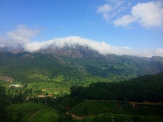
Pakshipathalam Bird Sanctuary is located seven kilometers northeast of Thirunelli town. The hill is 32 kilometers away from the district headquarters of Kalpetta. The hill lies 1740 m above sea level. [1] Papanasini River flows from Brahmagiri hill and irrigates the area. This river is believed to have the capacity to wash away all sins as the word 'papa' means sin and 'nashini' means destroy in Malayalam.
Pakshi Pathalam is rich in bird diversity. There is a cave here which is believed to be used by saints of olden times. [2] The undulating hills of Pakshipathalam are also famous as a trekking site. [3]

The Western Ghats, also known as the Sahyadri mountain range, is a mountain range that covers an area of 160,000 km2 (62,000 sq mi) in a stretch of 1,600 km (990 mi) parallel to the western coast of the Indian peninsula, traversing the states of Gujarat, Maharashtra, Goa, Karnataka, Kerala and Tamil Nadu. It is a UNESCO World Heritage Site and is one of the 36 biodiversity hotspots in the world. It is sometimes called the Great Escarpment of India. It contains a very large proportion of the country's flora and fauna, many of which are endemic to this region. The Western Ghats are older than the Himalayas. They influence Indian monsoon weather patterns by intercepting the rain-laden monsoon winds that sweep in from the south-west during late summer. The range runs north to south along the western edge of the Deccan Plateau and separates the plateau from a narrow coastal plain called the Western Coastal Plains along the Arabian Sea. A total of 39 areas in the Western Ghats, including national parks, wildlife sanctuaries and reserve forests, were designated as world heritage sites in 2012 – twenty in Kerala, ten in Karnataka, six in Tamil Nadu and four in Maharashtra.

Wayanad is a district in the north-east of Indian state Kerala with administrative headquarters at the municipality of Kalpetta. It is the only plateau in Kerala. The Wayanad Plateau forms a continuation of the Mysore Plateau, the southern portion of Deccan Plateau which links Western Ghats and Eastern Ghats. It is set high in the Western Ghats with altitudes ranging from 700 to 2100 meters. Vellari Mala, a 2,240 m (7,349 ft) high peak situated on the trijunction of Wayanad, Malappuram, and Kozhikode districts, is the highest point in Wayanad district. The district was formed on 1 November 1980 as the 12th district in Kerala, by carving out areas from Kozhikode and Kannur districts. An area of 885.92 km2 of the district is forested. Wayanad has three municipal towns—Kalpetta, Mananthavady and Sulthan Bathery. There are many indigenous tribes in this area. The Kabini River, a tributary of Kaveri River, originates at Wayanad. Wayanad district, along with the Chaliyar valley in neighbouring Nilambur in Malappuram district, is known for natural gold fields, which are also seen in other parts of the Nilgiri Biosphere Reserve. Chaliyar river, which is the fourth longest river of Kerala, originates on the Wayanad plateau. The historically important Edakkal Caves are located in Wayanad district.

Ponmudi also known as Ooty of South Kerala, Kashmir of Kerala is a hill station in the Peringamala gramapanchayath of Trivandrum District of Kerala in India. It is located 22km west of Vithura town, 53 km north-east of Trivandrum City, 78 km south-east of Varkala town and 69 km north-east of Kovalam Beach at an altitude of 1,100 m (3,600 ft). Ponmudi (Varayadumotta) peak is a part of the Western Ghats mountain range that runs parallel to the Arabian Sea. Ponmudi is a popular honeymoon destination in South India. The normal temperature of Ponmudi is between 18 and 25 °C.

Brahmagiri, is a mountain range in the Western Ghats of south India. It is situated on the border between Kodagu district in Karnataka state in the north and Wayanad district of Kerala state on the south. Brahmagiri Hill, at 1608 m height, is a scenic tourist attraction. The top of Brahmagiri Hill is well forested and has much wildlife.

The Kabini River is one of the major tributaries of the river Cauvery in southern India. It originates near Kavilumpara in Kozhikode district of Kerala state by the confluence of the Panamaram River and the Mananthavady River. It flows eastward through Wayanad district, entering Mysore district of Karnataka, to join the Kaveri River in Mysore district of Karnataka

Wayanad Wildlife Sanctuary is a wildlife sanctuary in Wayanad, Kerala, India with an extent of 344.44 km2 (132.99 sq mi) and four hill ranges namely Sulthan Bathery, Muthanga, Kurichiat and Tholpetty. A variety of large wild animals such as gaur, Asian elephant, deer and tiger are found there. There are also quite a few unusual birds in the sanctuary. In particular, Indian peafowl tend to be very common in the area. Wayanad Wildlife Sanctuary is the second largest wildlife sanctuary in Kerala. It is bestowed with lush green forests and rich wildlife. This wildlife area houses some of the rare and endangered species of both flora and fauna.

Thirunelli Temple is an ancient temple dedicated to Lord Maha Vishnu on the side of Brahmagiri hill in Kerala, India, near the border with Karnataka state. The temple is at an altitude of about 900m in north Wayanad in a valley surrounded by mountains and beautiful forests. It is 32 km away from Manathavady.

Papanasini is the mountain stream in wayanad district of kerala.

Gonikoppal is a census town in the Kodagu district of the Indian state of Karnataka.

Kottiyoor is a village and Grama Panchayat situated in eastern hilly area of Kannur district in Kerala state. Kottiyoor is the 23rd Wildlife Sanctuary of Kerala, located in the serene hills of Western Ghats. The ancient pilgrimage conducted here yearly, called 'Kottiyoor Vysakha Mahotsavam' attracts arround 50,000devotees every year. The Vavali river flows through Kottiyoor.

Pushpagiri, at 5,626 feet (1,715 m) ft, is the highest peak in Pushpagiri Wildlife Sanctuary in the Western Ghats of Karnataka. It is located in the Somwarpet Taluk, 20 kilometres (12 mi) from Somwarpet in the northern part of Kodagu district on the border between Dakshina Kannada and Kodagu district and hassan districts. It is 4th highest peak of Karnataka.

Karnataka is the sixth largest state in India and has been ranked as the third most popular state in the country for tourism in 2014. It is home to 507 of the 3600 centrally protected monuments in India, second only to Uttar Pradesh. The State Directorate of Archaeology and Museums protects an additional 752 monuments and another 25,000 monuments are yet to receive protection.

The Irupu Falls are located in the Brahmagiri Range in the Kodagu district of Karnataka, India, bordering the Wayanad district of Kerala. It is a fresh water cascade and is situated at a distance of 48 km from Virajpet on the highway to Nagarhole. The Falls are also known as the Lakshmana Tirtha Falls, derived from the name of the tributary of Cauvery which starts from these falls, the Lakshmana Tirtha River.

Kutta is a small village in Ponnampet taluk of Kodagu, in Karnataka state of India.

Thirunelly is a village in Wayanad district in the state of Kerala, India.

Kattikkulam (Kartikulam) is a small town near Mananthavady in Wayanad district, Kerala, India.The office of the Thirunelly Gramapanchayath is located at Kartikulam.

The Wayanad District of Kerala, India has a wide variety of tourist attractions ranging from religious sites to natural, and historical sites. This district is divided into three towns, Kalpetta, Sultan Bathery and Mananthavady. All Major Tourism destinations in the district are maintained by the District Tourism Promotion Council.

Appapara or Appappara is a small village in Wayanad district of Kerala state, India.

Kottiyoor Wildlife Sanctuary is Wildlife Sanctuary located in Kannur district of Kerala, India. Situated near to other sanctuaries in Kerala and Karnataka, the Kottiyoor Wildlife Sanctuary is rich in biodiversity and rich flora and fauna.
Coordinates: 11°55′39″N75°59′51″E / 11.927498°N 75.997395°E