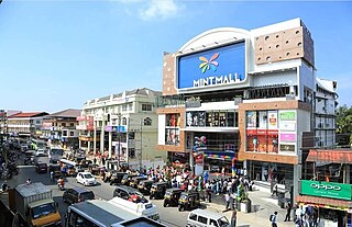
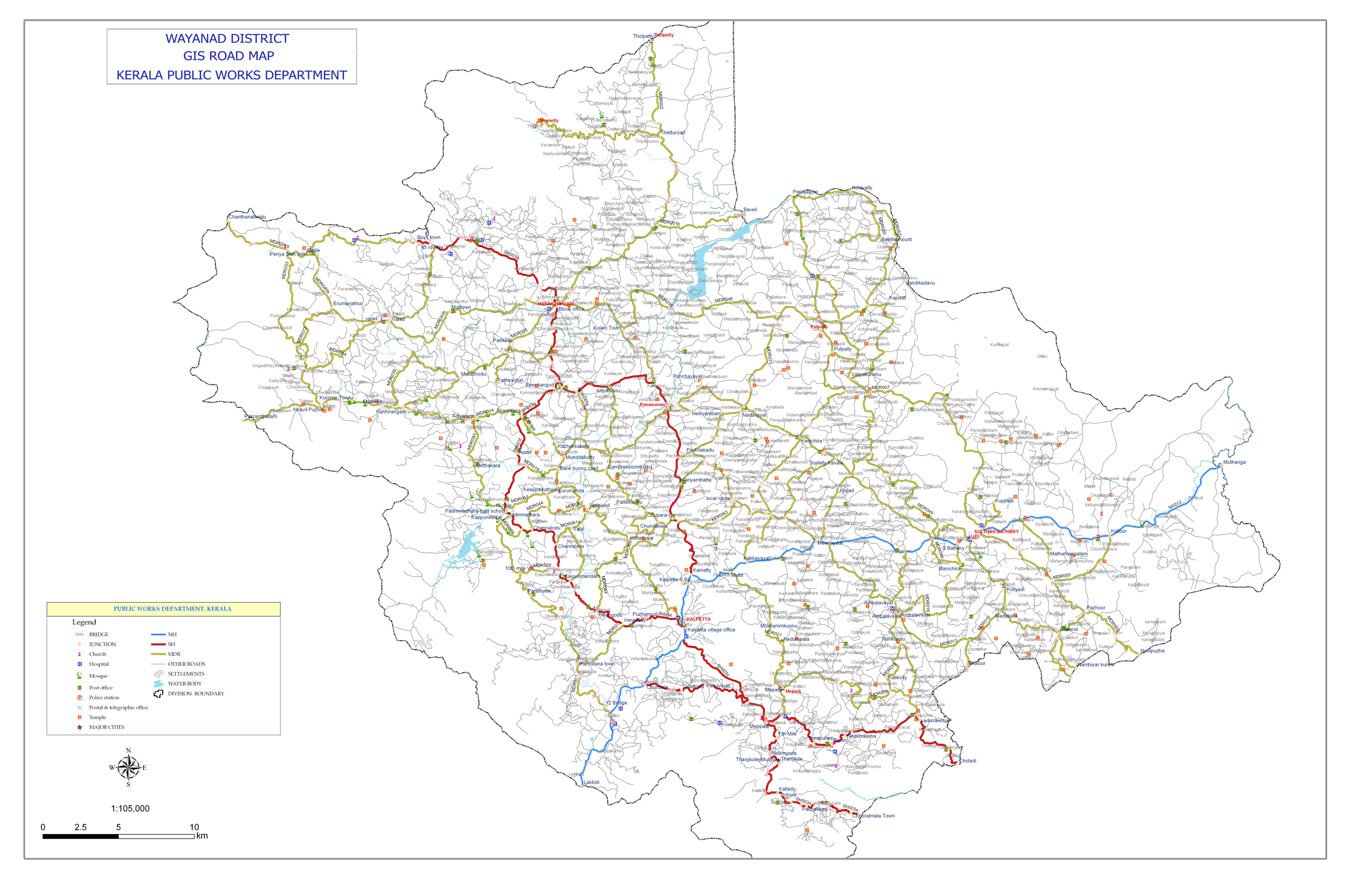
Transportation in Wayanad

Last updated

Wayanad Hill Road Wayanad churam.JPG
Wayanad Hill Road
Hairpin Bend KSRTC at Wayanad Ghat Section.jpg
Hairpin Bend

The district capital of Wayanad is Kalpetta town. Kalpetta has very good road connectivity with the rest of Kerala and neighboring South Indian cities. National Highway 766 (India) NH766 connects Kalpetta with Kozhikode and Mysore. State Highways connect Kalpetta with Ooty in Tamil Nadu and Madikeri in Karnataka.

Contents

Night Traffic Ban

En route to Mysore on NH 766, past Wayanad district boundary, which is also the Kerala state boundary, NH 766 passes through Bandipur National Park. There is a night traffic ban imposed on this stretch since 2009. [1] The alternate road to take is, leave NH766 at Kalpetta and proceed to Mysore through Mananthavady, Kutta, Gonikoppal, and Hunsur. The authorities has announced new National Highway connecting Mysore with Malappuram via Gonikoppa, Kutta, Mananthavadi, Kuttiyadi, Naduvannur, Atholi, Purakkatteri joining Kozhikode byepass. However there is a protest against this as part of protest against Night Travel ban in NH766 as this proposed Highway will be an alternative route but it may make NH766 closed forever in future and Sulthan Bathery will no longer have connection to Karnataka.

Road routes

Kalpetta – Mysore (132 km): Sulthan Bathery – Gundlupet - Mysore(NH766)(Night travel not allowed)

Kalpetta – Mysore (115 km): Mananthavady – Bavali – Handpost (Heggadadevana kote) - Mysore(SH33) (Night travel not allowed) Bavali forest checkpost will be open only up to 6 PM.

Kalpetta – Mysore (159 km): Mananthavady - Kutta- Mysore (Night travel allowed) Road is bumpy.

Kalpetta - Kozhikode (99 km): Padinjarathara - Perambra

Kalpetta – Ooty (127 km) : Meppadi – Gudalur

Kalpetta – Madikeri (135 km): Mananthavady - Kutta

Kalpetta - Kannur (123 km) : Mananthavady - Koothuparamba

Kalpetta - Malappuram (99 km) : Thamarassery - Areekkode - Manjeri

Kalpetta - Kozhikode (72 km) : Vythiri - Thamarassery

The authorities has announced new National Highway connecting Mysore with Malappuram via Gonikoppa, Kutta, Mananthavadi & Kalpetta.

Kalpetta

Kalpetta has very good road connectivity with the rest of Kerala and neighboring South Indian cities. NH 766 connects Kalpetta with Kozhikode and Mysore. State Highways connect Kalpetta with Ooty in Tamil Nadu and Madikeri in Karnataka.

Highways

Wayanad Ghat Road (Mountain Pass) on NH 766 Mountain Pass Wayanad.jpg
Wayanad Ghat Road (Mountain Pass) on NH 766

All national and state highways passing through Wayanad District intersect at Kalpetta, [2] making it a strategic location and the "Gateway of Wayanad":

Night Traffic Ban on NH 766 at Bandipur National Park

En route to Mysore on NH 766, past Wayanad district boundary, which is also the Kerala state boundary, NH 766 passes through Bandipur National Park. There is a night traffic ban imposed on this stretch since 2009. [1] The alternate road to take is, leave NH 766 at Kalpetta and proceed to Mysore through Mananthavady, Kutta, Gonikoppal, and Hunsur.

Road routes

Kalpetta – Bangalore (280 km): Sulthan Bathery – Gundlupet - Mysore(NH766)(Night travel not allowed)

Kalpetta – Bangalore (332 km): Mananthavady - Kutta- Mysore (Night travel allowed)

Kalpetta - Mysore : 130 km via Sulthan Bathery (NH766 - No Night Travel), 172 km via Mananthavady, Kutta (Use for Night Travel).

Kalpetta - Kozhikode (99 km): Padinjarathara - Perambra


Kalpetta – Ooty (127 km) : Meppadi – Gudalur

Kalpetta – Madikeri (135 km): Mananthavady - Kutta

Kalpetta - Kannur (123 km) : Mananthavady - Koothuparamba

Kalpetta - Malappuram (99 km) : Thamarassery - Areekkode - Manjeri

Kalpetta - Kozhikode (72 km) : Vythiri - Thamarassery

Sultan Battery

Sultan Battery has a very good road connectivity with south Indian states. The major Road is NH 766 connected to Mysore, Bangalore and Kozhikode, two State highways connected to Ooty and Coimbatore and a state highway connected to Mangalore, Kannur, Thalassery, Kasaragod and Malappuram.

Sulthan Bathery is the biggest transport hub of Wayanad district. It is located near the border with the Karnataka state and Tamil Nadu state. There is a major Kerala Transport Depot in Sulthan Bathery. Most of the long-distance buses to Kozhikode, Ooty and Bangalore start from this depot. The town also has two smaller bus stations for local travellers.

Mananthavady

Mainly five Ghat roads are used for reaching Mananthavady from coastal towns and lower hilly towns of Kerala:

  1. From Thalassery: Nedumpoil-Periya Ghat road, which connects Kasargod, Kannur, Thalassery and Kuthuparamba with Wayanad
  2. From Kozhikode: Thamarassery-Lakkidi Ghat road, part of NH 766, which connects Kozhikode and the rest of Kerala, south of Kozhikode with Wayanad
  3. From Vatakara: Kuttiady-Pakramthalam Ghat road, which connects Thalassery, Vatakara, Nadapuram, Kuttiady and Thottilpalam with Wayanad
  4. From Iritty: Kottiyoor-Ambayathode-Palchuram-Boys Town Ghat road, which connects lower hilly towns and villages of Kannur and Kasargod districts with Wayanad. The towns are Panathur, Vellarikundu, Chittarikkal, Udayagiri, Cherupuzha, Alakode, Sreekandapuram, Payyavoor, Iritty, Peravoor, Kelakam, Kottiyoor, etc.
  5. From Nilambur: Vazhikkadavu-Nadukani Ghat road, which connects Nilambur, Palakkad, Thrissur and Malappuram, with Wayanad.

See also

Related Research Articles

<span class="mw-page-title-main">Brahmagiri (Karnataka)</span> Mountain range in India

Brahmagiri, is a mountain range in the Western Ghats of south India. It is situated on the border between Kodagu district in Karnataka state in the north and Wayanad district of Kerala state on the south. Brahmagiri Hill, at 1608 m height, is a scenic tourist attraction. The top of Brahmagiri Hill is well forested and has much wildlife.

<span class="mw-page-title-main">Sultan Bathery</span> Town in Kerala, India

Sultan Bathery is a town and municipality in the Wayanad district of Kerala, India, near its borders with Tamil Nadu and Karnataka. Once known as a strategic location in the Malabar region, Sultan Bathery is the headquarters of the Sultan Bathery taluk.

<span class="mw-page-title-main">Oorpally</span> Town in Kerala, India

Oorpally is a small village near Koyileri, Mananthavady on the banks of the river Kabini in the Wayanad district of Kerala state, south India.

<span class="mw-page-title-main">Nadavayal</span> Village in Kerala, India

Nadavayal is a small village town near Panamaram in Wayanad district, Kerala, India. This small town hosted early migrants from Travancore (Thiruvithaamkoor).

<span class="mw-page-title-main">Kaniyambetta</span> Village in Kerala, India

Kaniyambetta or Pachilakkad is a village in the Wayanad district of Kerala state, southern India. It is about 8 km from the district capital Kalpetta.

<span class="mw-page-title-main">Kottathara</span> Village in Kerala, India

Kottathara or Venniyode is a gram panchayat of Wayanad district, Kerala State, India.

<span class="mw-page-title-main">Ambalavayal</span> Town in Kerala, India

Ambalavayal is a village in Wayanad district in the state of Kerala, India. The Wayanad Heritage Museum is located in the village.

Anjukunnu is a village in Wayanad district in the state of Kerala, India.

<span class="mw-page-title-main">Irulam</span> Village in Kerala, India

Irulam

Kanjirangad is a village in Wayanad district in the state of Kerala, India.

Nalloornad is a village near Mananthavady in Wayanad district in the state of Kerala, India.

Noolpuzha is a village near Sulthan bathery in Wayanad district in the state of Kerala, India.

<span class="mw-page-title-main">Padinharethara</span> Town/Panchayat in Kerala, India

Padinjarathara is a Town and important junction in Wayanad district in the state of Kerala, India. The biggest earth dam in Asia Banasura Sagar And Meenmutti Waterfalls is situated in this Village.State Highway 54 passes through Padinjarathara

<span class="mw-page-title-main">Panamaram</span> Town in Kerala, India

Panamaram is a town,village in Wayanad district in the state of Kerala, India.

Porunnanore is a village near Tharuvana in Wayanad district in the state of Kerala, India.

<span class="mw-page-title-main">Thirunelly</span> Village in Kerala, India

Thirunelly is a village in Wayanad district in the state of Kerala, India.

<span class="mw-page-title-main">Thrissilery</span> Village in Kerala, India

Thrissilery is a village in Wayanad district in the state of Kerala, India.

<span class="mw-page-title-main">National Highway 766 (India)</span> National highway in India

National Highway 766 is a National Highway in Southern India. NH 766 connects Kozhikode in Kerala with Kollegal in Karnataka via Mysore. Of the total distance of 272 km, 117 km is in Kerala and 155 is in Karnataka. At Kollegal, it joins National Highway 948, which connects Bengaluru and Coimbatore. The highway passes through dense forests of Western ghats of India. The NH-766 passes through 19.7 km Bandipur National Park and Wayanad wild life sanctuary.

<span class="mw-page-title-main">Kunhome</span> Town in Kerala, India

Kunhome' is a small village situated in Thondernadu Panchayath, Wayanad district, Kerala, India. It has a diverse cultural heritage. Kunhome is a hub for domestic and international tourists. The village has a distinct identity in tourist destinations of Wayanad due to its historical and cultural heritage.,

<span class="mw-page-title-main">Kattikkulam</span> Place in Kerala, India

Kattikkulam (Kartikulam) is a small town near Mananthavady in Wayanad district, Kerala, India.The office of the Thirunelly Gramapanchayath is located at Kartikulam.

References

  1. 1 2 "Bandipur-road-to-be-closed-at-night". DNA India. Retrieved 11 May 2014.
  2. "Road map of Wayanad district". Kerala PWD. Retrieved 2 May 2014.
  3. "Padinajrethara Poozhithode road". The Hindu. Retrieved 2 May 2014.