| Palas پالس | |
|---|---|
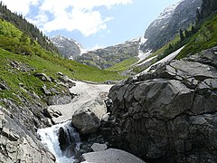
Palas Valley | |
 Palas | |
| Coordinates: 35°36′N73°00′E / 35.6°N 73.00°E | |
| Country | |
| Province | |
| Population (2017) [1] | |
| • Total | 275,461 |
| Time zone | PST (UTC+5) |
Palas (Urdu : پالس) is a tehsil and valley in Kolai-Palas District, Khyber Pakhtunkhwa Province, Pakistan.
A tehsil is an administrative division in some countries of South Asia. It is an area of land with a city or town that serves as its administrative centre, with possible additional towns, and usually a number of villages. The terms in India have replaced earlier geographical terms, such as pargana, pergunnah and thannah.
Kolai-Pallas Kohistan District is a district in Hazara Division of Khyber Pakhtunkhwa province in Pakistan. It was a sub division of Kohistan district of Hazara division till it was made a separate district in 2017.

Khyber Pakhtunkhwa, formerly known as North-West Frontier Province, is one of the four administrative provinces of Pakistan, located in the northwestern region of the country along the international border with Afghanistan. It was previously known as the North-West Frontier Province until 2010 when the name was changed to Khyber Pakhtunkhwa by the 18th Amendment to Pakistan's Constitution, and is known colloquially by various other names. Khyber Pakhtunkhwa is the third-largest province of Pakistan by the size of both population and economy, though it is geographically the smallest of four. Within Pakistan, Khyber Pakhtunkhwa shares a border with Punjab, Balochistan, Azad Kashmir, Gilgit-Baltistan, and Islamabad. It is home to 17.9% of Pakistan's total population, with the majority of the province's inhabitants being Pashtuns. The province is the site of the ancient kingdom Gandhara, including the ruins of its capital Pushkalavati near modern-day Charsadda. Originally a stronghold of Buddhism, the history of the region was characterized by frequent invasions under various Empires due to its geographical proximity to the Khyber Pass.


