Palena Province

Last updated
Palena Province

Provincia de Palena
Logotipo de la Gobernacion de Palena.svg
Seal
Provincia de Palena.svg
Location in the Los Lagos Region
Chile location map.svg
Red pog.svg
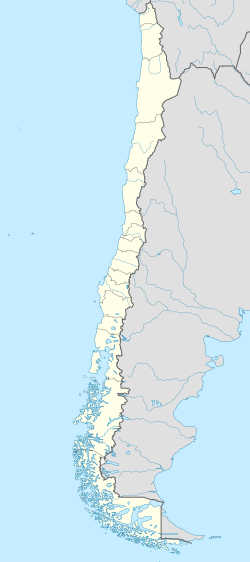
Palena Province
Location in Chile
Coordinates: 43°00′S72°20′W / 43.000°S 72.333°W / -43.000; -72.333 Coordinates: 43°00′S72°20′W / 43.000°S 72.333°W / -43.000; -72.333
Country Chile
Region Los Lagos
Capital Futaleufú
Communes Chaitén
Futaleufú
Hualaihué
Palena
Government
  Type Provincial
   Governor Osvalo Oelckers Oelckers (UDI)
Area
[1]
  Total15,301.9 km2 (5,908.1 sq mi)
Population
 (2012 Census) [1]
  Total16,137
  Density1.1/km2 (2.7/sq mi)
  Urban
7,624
  Rural
11,347
Sex
[1]
  Men10,255
  Women8,716
Time zone UTC-4 (CLT)
  Summer (DST) UTC-3 (CLT)
Area code(s) 56 + 65
Website Government of Palena

Palena Province (Spanish : Provincia de Palena) is the southernmost administrative area in Chile's Los Lagos Region Los Lagos (X). The area is also called Continental Chiloe or Northern Patagonia, as geographers consider the Palena Province to be the starting point of Chilean Patagonia which extends south from Palena all the way to Tierra del Fuego. Palena Province is remote, beautiful, and difficult to access. In fact, Palena is one of the most sparsely populated provinces in the country and features a stunning geography characterized by steep fjords, wild rivers, hot springs, and numerous snow-capped volcanos. Chile's Austral Highway (Carretera Austral) is not continuous through the jagged geography of Palena Province. Motorists accessing the area by car are required to take two ferries across fjords to cross the province.

Contents

Historically, Chaiten was the provincial capital. Due to the eruption of Chaitén Volcano and the subsequent destruction of that town, Futaleufú was named the new provincial capital in March 2009. Major tourist attractions in Palena Province include the Pumalín Park, one of the largest established wilderness protection areas in the world, Yelcho Lake, and the Futaleufu River. Pumalin was the dream of the late US philanthropist and environmental activist Douglas Tompkins, it is nowadays called the Pumalin Douglas Tompkins national park after its founder. The park has excellent infrastructure for camping and is divided into two parts by the Huinay Ranch. Yelcho Lake is considered a prime destination for fly fishing. The Futaleufu River is considered by specialized media to be one of the three greatest whitewater runs in the world.

Due to its location in front of Chiloé Island Palena Province is sometimes called Continental Chiloé (Chiloé Continental). Palena Province is named after the Palena Lake, which in turn was named by the Italian Jesuit Nicolás Mascardi after the town of Palena in Abruzzo, Italy.

Administration

As a province, Palena is a second-level administrative division, governed by a provincial governor appointed by the president. The province comprises four communes, each governed by a municipality, headed by an alcalde.

Communes

Geography and demography

According to the 2002 census by the National Statistics Institute (INE), the province spans an area of 15,301.9 km2 (5,908 sq mi) and had a population of 18,971 inhabitants (10,255 men and 8,716 women), giving it a population density of 1.2/km2 (3/sq mi). It is the seventh least populated province in the country. Of these, 7,624 (40.2%) lived in urban areas and 11,347 (59.8%) in rural areas. Between the 1992 and 2002 censuses, the population grew by 1.2% (223 persons). [1]

Related Research Articles

Los Lagos Region Region of Chile

Los Lagos Region is one of Chile's 16 regions, which are first order administrative divisions, and comprises four provinces: Chiloé, Llanquihue, Osorno and Palena. The region contains the country's second largest island, Chiloé, and the second largest lake, Llanquihue.

Futaleufú River river in Chile and Argentina

The Futaleufú River, located in northern Patagonia, is one of the premier whitewater rivers in the world. One of only two rivers to cross the 5,308 kilometer Chile-Argentina border, the Futaleufú headwaters can be found in the glacial snow melt of the UNESCO protected Los Alerces National Park in Argentina. The river gorge drops as low as 1,700 metres (5,600 ft) below the surrounding glaciated peaks. The name Futaleufú is an indigenous Mapuche word meaning "Big River.” Locals refer to the valley as "un paisaje pintado por Dios"—a landscape painted by God.

Huinay is a tract of land belonging to the San Ignacio del Huinay Foundation. This territory covers nearly 350 km2 (135 sq mi) in the Commune of Hualaihué, in Los Lagos Region of Chile. It lies between the Comau or Leptepu fjord and the border with the Republic of Argentina in Palena Province. Its location is 42°22′S72°24′W. Huinay also divides the private Pumalín Park founded by American Douglas Tompkins into two parts. Tompkins wants to purchase it to unify his park, however, this has met with strong opposition from the people in the hamlet of Huinay.

Douglas Tompkins American businessman and environmentalist

Douglas Rainsford Tompkins was an American conservationist, outdoorsman, philanthropist, filmmaker, agriculturalist, and businessman who assembled and preserved the land which became the largest gift of private land to any South American government.

Pumalín Park national monument of Chile

Pumalín Park is a 400,000 ha nature reserve in the Palena Province of Chile, created by the United States environmental foundation The Conservation Land Trust, which was endowed and led by the American business magnate Douglas Tompkins. Designated a Nature Sanctuary in 2005, Pumalín was Chile's largest private nature reserve and operated as a public-access park, with an extensive infrastructure of trails, campgrounds, and visitor centers. By an accord announced on 18 March 2017, the park was gifted to the Chilean state and consolidated with another 4,000,000 ha to become part of South America's largest national park.

Osorno Province Province in Los Lagos, Chile

Osorno Province is one of the four provinces in the southern Chilean region of Los Lagos (X). The province has an area of 9,223.7 km2 (3,561 sq mi) and a population of 221,496 distributed across seven communes. The provincial capital is the city of Osorno.

Dalcahue City and Commune in Los Lagos, Chile

DalcahueSpanish pronunciation: [dalˈkawe] is a port city and a commune on Chiloé Island, Los Lagos Region, Chile.

Quellón City and Commune in Los Lagos, Chile

Quellón is a Chilean port city and commune in southern Chiloé Island, Los Lagos Region. It is considered the southern end-station of the Panamerican Highway and the Pacific Coastal Highway. The city is a hub for aquaculture and fisheries in southern Chiloé and the Guaitecas and Chonos archipelagoes to the south. Various ferry lanes connects Quellón with the Patagonian settlements such as Melinka, Puerto Cisnes and Puerto Chacabuco.

Carretera Austral highway in Chile

The Carretera Austral is the name given to Chile's Route 7. The highway runs south for about 1,240 kilometers (770 mi) from Puerto Montt to Villa O'Higgins, passing through rural Patagonia.

Yelcho Lake lake in Chile

Yelcho Lake is a large fjord-shaped lake located in Chilean Patagonia, in southern Palena province of Los Lagos Region, Chile. The lake receives the waters of the Futaleufu River at its southern tip, near the tiny settlement of Puerto Ramirez. The river then flows northward through mountainous and glaciated terrain, until it outflows via the Yelcho River north-west and empties into Gulf of Corcovado, near Chaitén. The lake is a popular destination for fly fishing, and several lodges and hotels operate on its shores. Yelcho Lake is most frequently accessed via the town of Chaitén to the north. Two small commercial airlines operate daily flights fromPuerto Montt. Another option is ferry service direct from Puerto Montt, the bimodal ferry service from the town of Hornopiren, or direct from the port of Quellón on the island of Chiloe on the other side of the Gulf of Corcovado. Traffic on the Carretera Austral along the western shore of Yelcho Lake was interrupted in December 2017 due to a mudslide in the settlement of Villa Santa Lucía, which killed 22 people. The road reopened in February 2018.

Corcovado Volcano mountain in Palena Province Chile

Corcovado Volcano is a stratovolcano located about 25 kilometres (16 mi) south of the mouth of Yelcho River, in the Palena Province, Los Lagos Region, Chile. The glacially eroded volcano is flanked by Holocene cinder cones. The volcano's base has likely prehistoric lava flows that are densely vegetated. The most distinctive feature of this volcano is its stepped top, similar to that of Puntiagudo Volcano. At its foot lies a series of beautiful lakes. Corcovado dominates the landscape of Gulf of Corcovado area and is visible from the Chiloé Island, weather allowing.

Hornopirén National Park

Hornopirén National Park is located in the Andes, in the Palena Province of Chile's Los Lagos Region, also known as Region X. The park contains 482 km2 (186 sq mi) of rugged mountains and unspoiled Valdivian temperate rain forests. This national park borders the northern portion of Pumalín Park. The Carretera Austral passes close to the park. In the vicinity of the park lie Hornopirén and Yate volcanoes.

Zona Austral geographical region of Chile

The Zona Austral is one of the five natural regions into which CORFO divided continental Chile in 1950 corresponding to the Chilean portion of Patagonia. It is surrounded by the Zona Sur and the Chacao Channel to the north, the Pacific Ocean and Drake's Passage to the south and west, and the Andean mountains and Argentina to the east. If excluding Chiloé Archipelago Zona Austral covers all of Chilean Patagonia.

Chaitén Town and Commune in Los Lagos, Chile

Chaitén is a Chilean town, commune and former capital of the Palena Province in Los Lagos Region. The town is north of the mouth of Yelcho River, on the east coast of the Gulf of Corcovado. The town is strategically close to the northern end of the Carretera Austral, where the highway goes inland. The Desertores Islands are part of the commune.

Futaleufú, Chile Town and Commune in Los Lagos, Chile

Futaleufú is a Chilean town and commune located in Northern Patagonia. Located at the confluence of several river valleys 10 kilometers from the Argentinian border, Futaleufú is the provincial capital of Palena Province, Los Lagos Region. Futaleufu is a frontier town with a growing tourism industry based on adventure tourism—most specifically whitewater rafting—but also fishing, mountain biking, trekking, and canyoning. Located 7 miles from the Argentinian border, Futaleufu is most easily accessed from airports in Esquel and Bariloche, Argentina. The town is named after the crystal blue Futaleufú River, widely considered to be one of the best whitewater rafting rivers in the world. The name Futaleufu derives from a Mapudungun word meaning "Big River".

Huequi mountain in Chile

Huequi is a stratovolcano located in Los Lagos Region of Chile. It lies at the centre of Ayacara Peninsula and close to the Gulf of Ancud. It has an elevation of 1,318 metres (4,324 ft). It has a sharp summit and reportedly "smoked" in the 1950s and is made up from a lava dome complex situated in a depression of unclear origin, a postglacial lava dome Calle and a Pleistocene Porcelana volcano with Holocene parasitic cones.

Palena is a Chilean commune located in Palena Province, Los Lagos Region. The commune is named after Palena Lake.

Puqueldón is Chilean commune in Chiloé Archipelago which is part of Chiloé Province and Los Lagos Region. The commune is located on Lemuy Island and consists of eight villages the biggest of which is Puqueldón. Puqueldón was one of the towns to receive the Bill & Melinda Gates Foundations scholarship in 2002.

Quinchao Commune in Los Lagos, Chile

Quinchao is a Chilean commune located in Chiloé Province, Los Lagos Region. The seat of government lies in the town of Achao on the island.

Lake Cholila

Lake Cholila is a lake in Chubut Province, Argentina. Lake Cholila is the uppermost of several large lakes in the Futaleufú River system of Argentina that via Yelcho Lake and the Yelcho River flows into the Pacific Ocean in Chile. The lake is of glacial origin and occupies a narrow east to west valley between glaciated peaks of the Andes.

References

  1. 1 2 3 4 "Territorial division of Chile" (PDF) (in Spanish). National Statistics Institute. 2007. Retrieved 23 March 2011.