Pananchery

Last updated

Pananchery
village
Pananchery Mudikkode Siva Temple.jpg
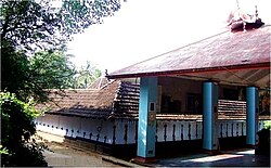
Mudikkode Shiva temple
Coordinates: 10°33′22″N76°18′29″E / 10.556°N 76.308°E / 10.556; 76.308 Coordinates: 10°33′22″N76°18′29″E / 10.556°N 76.308°E / 10.556; 76.308
CountryFlag of India.svg  India
State Kerala
District Thrissur
Population
 (2001)
  Total20,009
Languages
  Official Malayalam, English
Time zone UTC+5:30 (IST)
PIN
680652
Vehicle registration KL-08

Pananchery is a village and gram panchayat in Thrissur district in the state of Kerala, India. [1] It is located along the National Highway ( NH47) from Thrissur to Palakkad. Peechi, Pattikad, Kannara are located in Pananchery

Contents

Demographics

As of 2011 India census, Pananchery had a population of 45963 with 22394 males and 23569 females. [2]

Local government

Pananchery is the largest panchayath in the Thrissur district. It consists of 23 wards: Pananchery (village), Chembutra, Pattikkad, Thanippadam, Poovanchira, Chuvannamannu, Vanniyampara, Kombazha, Vazhakkumpara, Thekkumpadam, Edappalam, Mailuttumpara, Peechi, Thamaravellachal, Vilangannoor, Kannara, Veendassary, Payannam, Marakkal, Koottala, Alppara, Chirakkunnu and Mudikkode. [3]

Places of interest

The Kerala Forest Research Institute (KFRI), the popular tourist spot of Peechi Dam and the Kerala Engineering Research Institute (KERI) are located in Pananchery. The Peechi reservoir supplies water to the Thrissur town besides providing water for irrigation to the region. Kannara plantain research centre Kannara. Two government higher secondary schools (Pattikkad GHSS and Peechi GHSS) are situated in this panchayath. Chief minister Mr.Pinarayi Vijayan inaugurated "Honey and Banana Park" on 23 September 2019

Education

Related Research Articles

Nedumangad Town in Kerala, India

Nedumangad is an important town and municipality in Thiruvananthapuram metropolitan area of Thiruvananthapuram district in the Indian state of Kerala, and is the headquarters of Nedumangad tehsil and Nedumangad Revenue Division (RDO). It is a suburb of the extended metropolitan region of Thiruvananthapuram city. It is located around 16 km to the north-east of Thiruvananthapuram city centre on the Thiruvananthapuram – Shenkottah. It is an important hillside commercial center in the district. It is a growing commercial and educational hub and all important government institutions are situated in the town. Nedumangadu Market is important in South Kerala.

Muthuthala Village in Kerala, India

Muthuthala is a small town, village and gram panchayat. It lies northwest of Pattambi in Palakkad district, of the state of Kerala, India. It is located on the banks of the Bharathapuzha River. The infrastructure of the panchayath is divided into Kodumunda and Muthuthala.Muthuthala, Kodumunda and Karakkuth are important centres. The adjacent villages to Muthuthala are Pallippuram, Koppam and Pattambi. The major institutions are GOHSS Pattambi, GHSS Kodumunda, GLPS Kodumunda AMLP Kodumunda, Aups muthuthala, Aups perumudiyoor, SBI muthuthala etc. Also there are temples such as sree muthassiyar kavu, ayappan kavu, Ganapthi temple muthuthala. Siva temple perumudiyoor, kozhikottii temple etc. The main Islamic symbol of this village is Muhyidheen Juma Masjid located at Muthuthala centre. An Islamic educational institution named as Thanveerul Islam Madrassa is also running near to this. Thes agnostoma somayagam is conducted at perumudiyoor on 2016. Lakhs of people visited there. Major cultivation is paddy here. Banana and rubber plantations are also abundant here.

Thrissur district District in Kerala, India

Thrissur, is one of the 14 districts in the Indian state of Kerala. It is situated in the central part the state. Spanning an area of about 3,032 km2 (1,171 sq mi), Thrissur district is home to over 9% of Kerala's population.

Edacheri is a small panchayath in the district of Kozhikode in the South Indian state of Kerala.

Kalliasseri Census Town in Kerala, India

Kalliasseri is a census town in Kannur district in the Indian state of Kerala. Kalliaseri Panchayat comprises two villages: Kalliasseri and Irinave.

Thrissur is a district situated in the central part of Kerala state, India. Thrissur District was formed on 1 July 1949. The headquarters of the district has the same name, Thrissur city. It is an important cultural centre, and is known as the "cultural capital" of Kerala. The number of schools in Thrissur District is numerous.

Kunnukara Town in Kerala, India

Kunnukara is a census town and panchayat in Paravur Taluk of Ernakulam district, Kerala, India. The village is situated on the airport road connecting North Paravur (NH66) and Nedumbassery (NH544). North Paravur is the nearest town, 7 km from this village. Aluva (10 km) and Angamaly (12 km) are also near to Kunnukara. Its administrative headquarters is in Kunnukara Town itself. The Mini Civil Station has four hospitals, all the Govt. offices, a Khadi Unit Supermarkets etc.

Aloor is a panchayat in the Chalakudy-Mukundapuram taluk in the Thrissur district of Kerala, India. It is near the towns of Irinjalakuda and Chalakudi. Since 1901, the name "Aloor" has been simplified to "Alur" by the Cochin State and Central Government departments.

Karuvarakundu Semi Urban Area in Kerala, India

Karuvarakundu is a semi-urban area in the eastern part of Malappuram district, Kerala, India. It is situated 32 kilometres (20 mi) east of Manjeri, 26 kilometres (16 mi) northeast of Perinthalmanna and 30 km southeast of Nilambur. The Olippuzha River, a tributary of the Kadalundipuzha, flows through the town. Karuvarakundu is close to the Western Ghats and hence prone to landslides. The Silent Valley National Park was included in Karuvarakundu until 1990's.

Panathady Village in Kerala, India

Panathady is a village in Kasaragod district in the state of Kerala, India. Panathady Panchayat is in Vellarikundu taluk. It is 36 kilometers away from the nearest municipality, Kanhangad, and it is 8 kilometers away from the Kerala-Karnataka border, Panathur.

Poothakkulam, also known as Bhoothakulam, is a village in Kollam district in the state of Kerala, India. The village is located 3.9 km away from Paravur, 11.4 km from Varkala and 23 km from Kollam. In 2011, it had a population of 628,451 residents. The village covers an area of 16.56 km2.

Maniyur (gram panchayat) Grama Panchayath in Kerala, India

Maniyur Grama Panchayat is located in Vadakara Taluk, in the Kozhikode district in the state of Kerala, India. It covers an area of 31.03 km2.

Kalanjoor Village in Kerala, India

Kalanjoor is a village or a small Township located in Pathanamthitta district state of Kerala, India. The place is 22 km away from district headquarters. As a part of Konni assembly constituency and Pathanamthitta. Kalanjoor is also a panchayath where share the border of Kollam and Pathanamthitta Dist as the part of Parakode block panchayath. This place has mixed with a population of Hindus, Muslims and Christians. The famous Hindu temple "Thrikalanjoor Sree Mahadeva Temple" situated in Kalanjoor Town close to Punalur Muvattupuzha Main Eastern Highway. This is one of the biggest Shiva temple in Pathanamthitta district and the first Sabarimala edathavalam on the way of Sabarimala from the Southern part of Pathanamthitta dist. So that this place is also known as the "Southern Gateway of Sabarimala". One of the famous Christian Orthodox church St. George Valyapalli also situated in the same village and one of the India's largest aqueduct is also passing through Kalanjoor as part of Kallada Irrigation Project (KIP). Many of the inhabitants of this village are settlers there due to the introduction of rubber plantations. A number of people from Kalanjoor are employed in abroad, mainly in the Middle East.

Vellarada is a border village situated in Thiruvananthapuram district in the state of Kerala, India. It is 42 km from Thiruvananthapuram. It is the southernmost part of Kerala state, sharing its border with Tamil Nadu. Vellarada is said to be the threshold to the high-range areas of the eastern part of Thiruvananthapuram district. The southernmost point of Western Ghats in Kerala is near Vellarada.

Avanur Village in Kerala, India

Avanur is a village in Thrissur district in the state of Kerala, India. Avanur is located around 3 km east of the Thrissur-Kunnamkulam highway from Mundur junction and around 8 to 9 km from Thrissur town. The new Government Medical College at Mulankunnathukavu is just 3.5 km from Avanur. Avanur Grama panchayath won the Swaraj Trophy for the best village panchayat in Kerala for the year 2000–2001. The award was given in recognition of the successful implementation of developmental programmes and efficient administration. Avanur is well connected by around 20 private buses plying through it to various places like Thrissur town, Mundur, Kunnamkulam, Chavakkad, Mundathikode, Medical College and Athani. The newly proposed a combined Medical University by Government of Kerala is being planned around the Thrissur Medical College sprawling across a lush green campus. This is planned to host universities for Evidence Based Medicine, Ayurveda, Homoeopathy, Siddha and Yunani systems of medicine.

Edathirinji is a village in Thrissur district in the state of Kerala, India.

Engandiyur is a village in the Chavakkad taluka of the Thrissur district in the state of Kerala, India. It has an area of 1411 hectares and harbours 5,760 households with total population of 23,101 as per the 2011 Census. The nearest town Chavakkad is at a distance of 8 km. Male population is 10,528 and female population is 12,573. Scheduled Caste Population is 615 and Scheduled Tribes population is 45. Census Location Code of the village is 627789.

Velur or Veloor is a village and panchayat in Kunnamkulam Taluk, Thrissur district, Kerala, India with a population of 22,155. Other places close to Velur are Kechery, Wadakkanchery etc.

Chembuthara or Chembutra is a small village in Kerala, India, known for its Makarachowa festival. It is situated about 11 km away from Thrissur center. It is located by the side of NH 544.

References

  1. "Census of India : Villages with population 5000 & above". Registrar General & Census Commissioner, India. Retrieved 10 December 2008.
  2. "Latest population of Pananchery panchayat".
  3. Government of Kerala Local Self Government: LSGI Election 2015 Thrissur - Pananchery Grama Panchayat