Lake Paringa is a small lake 50 kilometres north of Haast on the West Coast of New Zealand's South Island.
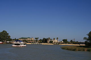
Renmark is a town in South Australia's rural Riverland area, and is located 254 km northeast of Adelaide, on the banks of the River Murray. The Sturt Highway between Adelaide and Sydney runs through the town; Renmark is the last major town encountered in South Australia when driving this route. It is 31 m above sea level. At the 2011 census, Renmark had a population of 7,491.

The Renmark Paringa Council is a local government area located adjacent to the Victorian border, in the Riverland, South Australia. The area is known for its various fruit production, and is heavily dependent on the River Murray as a water source. The council seat is at Renmark.

Renmark Airport is an airport serving Renmark, South Australia. It is located 4.25 nautical miles southwest of Renmark and operated by the Renmark Paringa Council.
The Riverland Independent Football League is an Australian rules football League located in South Australia's Riverland region. The league is the second division of the Riverland Football League, and features clubs from the smaller towns of the Riverland and Upper-Murray region.
The Hall River is a river on the West Coast of New Zealand. It drains Lake Paringa, flowing north to the Paringa River, which drains into the Tasman Sea.
The Paringa River is a river of the West Coast Region of New Zealand's South Island. It flows generally northwest from its origins in the Southern Alps southwest of Mount Hooker, reaching the Tasman Sea 10 kilometres southwest of Bruce Bay.

The Morkalla railway line was a railway line in the Millewa region of northwestern Victoria, Australia. It extended west from Red Cliffs railway station on the Mildura railway line into the wheat farming areas established as soldier settlements after World War I.
The Barmera railway line was the second railway built to develop the Murray Mallee region of South Australia, in 1913. It followed the success of the Pinnaroo railway line in 1906. Both lines branched east from Tailem Bend to the north of the main Melbourne–Adelaide railway. The Brown's Well line was the more northerly, and extended into country which had not been developed much before the railway, partly due to the absence of any viable transport route for produce. The original terminus of the Brown's Well railway was at Meribah, not far from the Victorian border.
Meribah is a small settlement in the Brown's Well district of the Murray Mallee region of South Australia, not far from the border with Victoria. It was the original terminus of the Barmera railway line from May 7th, 1913 until the line was extended to Paringa later the same year. It is about 70 km north of Pinnaroo and 45 km southeast of Loxton.
Wonuarra is a locality southeast of Paringa in the east end of the South Australian Riverland region. The locality is east of the Sturt Highway between Paringa and Yamba and extends from the highway to the state border.
The District Council of Swan Reach was a local government area in the Murraylands of South Australia from 1888 to 1933.

The Paringa Bridge carries the Sturt Highway across the Murray River in Paringa, South Australia. Until 1982, it also carried the Barmera railway line.
Mundic Creek is a locality in the Australian state of South Australia located in the Riverland in the state’s east on the southern side of the Murray River about 217 kilometres (135 mi) north-east of the state capital of Adelaide, and about 6 kilometres (3.7 mi) south-east of the municipal seat of Renmark.
Pike River Conservation Park is a protected area located in the Australian state of South Australia in the locality of Mundic Creek about 215 kilometres (134 mi) north-east of the state capital of Adelaide and about 2 kilometres (1.2 mi) south of the town of Paringa.
Pike River is a locality in the Australian state of South Australia located in the Riverland in the state’s east on the southern side of the Murray River about 210 kilometres (130 mi) north-east of the state capital of Adelaide and about 9 kilometres (5.6 mi) south-east of the municipal seat of Renmark.
The County of Alfred is one of the 49 cadastral counties of South Australia on the south banks of the River Murray. It was proclaimed by Governor James Fergusson in 1868 and named for Prince Alfred, second son of Queen Victoria, who visited the state in 1867.