Gordons Well, California

Last updated
Gordons Well
Unincorporated community
California Locator Map with US.PNG
Red pog.svg
Gordons Well
Location in California
Usa edcp location map.svg
Red pog.svg
Gordons Well
Gordons Well (the US)
Coordinates: 32°42′33″N114°57′52″W / 32.70917°N 114.96444°W / 32.70917; -114.96444 Coordinates: 32°42′33″N114°57′52″W / 32.70917°N 114.96444°W / 32.70917; -114.96444
Country United States
State California
County Imperial County
Elevation [1] 154 ft (47 m)

Gordons Well is an unincorporated community in Imperial County, California. [1] It is located 10.5 miles (17 km) southwest of Ogilby, [2] at an elevation of 154 feet (47 m). [1]

Unincorporated area Region of land not governed by own local government

In law, an unincorporated area is a region of land that is not governed by a local municipal corporation; similarly an unincorporated community is a settlement that is not governed by its own local municipal corporation, but rather is administered as part of larger administrative divisions, such as a township, parish, borough, county, city, canton, state, province or country. Occasionally, municipalities dissolve or disincorporate, which may happen if they become fiscally insolvent, and services become the responsibility of a higher administration. Widespread unincorporated communities and areas are a distinguishing feature of the United States and Canada. In most other countries of the world, there are either no unincorporated areas at all, or these are very rare; typically remote, outlying, sparsely populated or uninhabited areas.

Imperial County, California County in California ----, United States

Imperial County is a county in the U.S. state of California. As of the 2010 census, the population was 174,528. The county seat is El Centro. Established in 1907 from a division of San Diego County, it was last county to be formed in California.

California State of the United States of America

California is a state in the Pacific Region of the United States. With 39.6 million residents, California is the most populous U.S. state and the third-largest by area. The state capital is Sacramento. The Greater Los Angeles Area and the San Francisco Bay Area are the nation's second and fifth most populous urban regions, with 18.7 million and 9.7 million residents respectively. Los Angeles is California's most populous city, and the country's second most populous, after New York City. California also has the nation's most populous county, Los Angeles County, and its largest county by area, San Bernardino County. The City and County of San Francisco is both the country's second-most densely populated major city after New York City and the fifth-most densely populated county, behind only four of the five New York City boroughs.

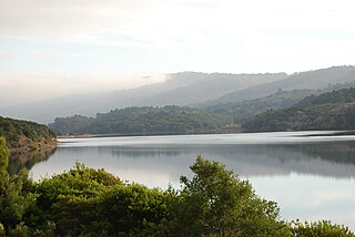
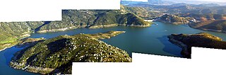
The Brock Reservoir, which is a man-made reservoir, is located near Gordons Well, California.

Brock Reservoir is a man-made reservoir located near Gordons Well, California. When a water request from Lake Mead is made, it takes time to travel the canal system to its destination. If the request is changed or canceled before it reaches its destination, the water is diverted to Brock Reservoir for storage. It has a small maximum volume of only 8,000 acre feet, but is expected to be filled and emptied many times each year. It holds water from the All-American Canal until it can be used for nearby agriculture.

Related Research Articles

Crystal Springs Reservoir

Crystal Springs Reservoir is a pair of artificial lakes located in the northern Santa Cruz Mountains of San Mateo County, California situated in the rift valley created by the San Andreas Fault just to the west of the cities of San Mateo and Hillsborough, and I-280. The lakes are part of the San Mateo Creek watershed.

San Andreas Lake lake in the United States of America

San Andreas Lake is a reservoir adjacent to the San Francisco Peninsula cities of Millbrae and San Bruno in San Mateo County, California. It is situated directly on the San Andreas Fault, which is named after the valley it is in.

Bethany Reservoir

The Bethany Reservoir is located 8 miles (13 km) northeast of Livermore, California, USA, on the California Aqueduct. It serves as the forebay for the South Bay Pumping Plant that feeds the South Bay Aqueduct.

San Mateo Creek (San Francisco Bay Area)

San Mateo Creek is a perennial stream whose watershed includes Crystal Springs Reservoir, for which it is the only natural outlet after passing Crystal Springs Dam.

Bullards Bar, California Former settlement in California, United States

Bullards Bar is a former gold mining settlement in Yuba County, California.

Garden Valley, Yuba County, California Former settlement in California, United States

Garden Valley is a former settlement in Yuba County, California. It was located 3.25 miles (5.2 km) west-southwest of Camptonville, at an elevation of 1909 feet. It was inundated by Bullards Bar Reservoir.

Oak Grove, Yuba County, California Former settlement in California, United States

Oak Grove is a former settlement in Yuba County, California. It was located on Dry Creek, 2.5 miles (4.0 km) west-southwest of Oregon House, at an elevation of 1158 feet. The site is covered by the Virginia Ranch Reservoir.

Uvas Reservoir

Uvas Reservoir is an artificial lake located west of San Martin, California in the United States. The reservoir is surrounded by a 626-acre (253 ha) park managed by the Santa Clara County Parks and Recreation Department. The park provides limited fishing ("catch-and-release"), picnicking, and hiking activities. Boating is not permitted in the reservoir.

Dinkey Lakes Wilderness

The Dinkey Lakes Wilderness is a federally designated wilderness area located 45 miles (72 km) northeast of Fresno, in the state of California, USA. It comprises 30,000 acres (12,141 ha) within the Sierra National Forest and was added to the National Wilderness Preservation System by the California Wilderness Act of 1984.

Lorraine, California Former settlement in California, United States

Lorraine is a former settlement in Butte County, California., it is now inundated by the Thermalito Afterbay reservoir. It lay at an elevation of 138 feet. Lorraine still appeared on maps as of 1952. It was located 5 miles (8.0 km) north-northeast of Biggs on the Sacramento Northern Railroad.

Outingdale, California Unincorporated community in California, United States

Outingdale is an unincorporated community in El Dorado County, California. It is located on the Middle Fork of the Cosumnes River 4 miles (6.4 km) north of Aukum, at an elevation of 1624 feet.

Gordon, California Unincorporated community in California, United States

Gordon is an unincorporated community in Fresno County, California. It is located on the Southern Pacific Railroad 5.25 miles (8 km) north-northwest of Clovis, at an elevation of 394 feet.

Trimmer, California Unincorporated community in California, United States

Trimmer is an unincorporated community in Fresno County, California. It is located 8 miles (13 km) north-northeast of Piedra, at an elevation of 1030 feet.

Dinsmore, California Unincorporated community in California, United States

Dinsmore is an unincorporated community in, California. It is located on the Van Duzen River, at an elevation of 2,415 feet (736 m). Dinsmore Airport and the Dinsmore Store are located nearby. Also nearby is the Mad River, Ruth, California and Ruth Reservoir.

Fish Springs, California Unincorporated community in California, United States

Fish Springs is an unincorporated community in Inyo County, California.

Reservoir is a former settlement in Kern County, California. It was located on the Southern Pacific Railroad 1 mile (1.6 km) south-southeast of Fram.

Sunset View, California Former settlement in California, United States

Sunset View is a former settlement in Nevada County, California, located near Grass Valley. It was listed on an official map as of 1949.

San Vicente Reservoir

San Vicente Reservoir is a reservoir created by the San Vicente Dam in San Diego County, California. It is located in the Cuyamaca Mountains, approximately 4.3 miles (6.9 km) north of Lakeside off California State Route 67.

References

  1. 1 2 3 U.S. Geological Survey Geographic Names Information System: Gordons Well, California
  2. Durham, David L. (1998). California's Geographic Names: A Gazetteer of Historic and Modern Names of the State. Clovis, Calif.: Word Dancer Press. p. 1422. ISBN   1-884995-14-4.