Related Research Articles
The Quechan are an aboriginal American tribe who live on the Fort Yuma Indian Reservation on the lower Colorado River in Arizona and California just north of the Mexican border. Members are enrolled into the Quechan Tribe of the Fort Yuma Indian Reservation. The federally recognized Quechan tribe's main office is located in Winterhaven, California. Its operations and the majority of its reservation land are located in California, United States.

The Fort Mohave Indian Reservation is an Indian reservation along the Colorado River, currently encompassing 23,669 acres (95.79 km2) in Arizona, 12,633 acres (51.12 km2) in California, and 5,582 acres (22.59 km2) in Nevada. Originally established in 1870, the reservation is home to approximately 1,100 members of the federally recognized Fort Mojave Indian Tribe of Arizona, California, and Nevada, a federally recognized tribe of Mohave people.

This is a list of the extreme points of North America: the points that are highest and lowest, and farther north, south, east or west than any other location on the continent. Some of these points are debatable, given the varying definitions of North America.
This is a list of the extreme points of The Americas, the points that are farther north, south, east or west than any other location on the continent. The continent's southernmost point is often said to be Cape Horn, which is the southernmost point of the Chilean islands. The Americas cross 134° of longitude east to west and 124° of latitude north to south.
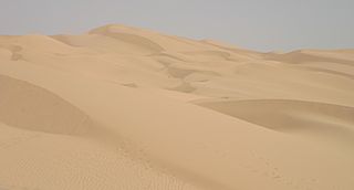
The Yuma Desert is a lower-elevation section of the Sonoran Desert in the southwestern United States and the northwest of Mexico. It lies in the Salton basin. The desert contains areas of sparse vegetation and has notable areas of sand dunes. With an average rainfall less than 8 inches (200 mm) each year, this is among the harshest deserts in North America. Human presence is sparse throughout, the largest city being Yuma, Arizona, on the Colorado River and the border of California.

Lost Lake is a desert community located along the west shore of the Colorado River. It also lies along U.S. Route 95 near the northeastern extent of Riverside County. Official U.S. Geological Survey feature ID is 245216 and NAD27 coordinates for the community are 34°00′44″N114°28′27″W. The community lies at the foot of Riverside Mountain, 34°00′49″N114°30′45″W, with a summit measuring 2,127 feet. The community is named for a lake, Lost Lake, located at 34°01′20″N114°28′21″W.

The Mojave Road, also known as Old Government Road, is a historic route and present day dirt road across what is now the Mojave National Preserve in the Mojave Desert in the United States. This rough road stretched 147 miles (237 km) from Beale's Crossing, to Fork of the Road location along the north bank of the Mojave River where the old Mojave Road split off from the route of the Old Spanish Trail/Mormon Road.

Ogilby is a ghost town in Imperial County, California, United States. Ogilby is located on the Southern Pacific Railroad 42 miles (68 km) east of El Centro, and 3.8 miles (6.1 km) north of Interstate 8 on County Road S34. The name is official for federal use, and a feature ID number of 252950 has been assigned. Ogilby is defined by the US Geological Survey as a populated place at 356 feet (109 m) AMSL elevation. NAD27 latitude and longitude are listed at 32°49′01″N114°50′20″W on the "Ogilby, California" 7.5-minute quadrangle (map). It is included in the Imperial County Air Pollution Control District. It lies at an elevation of 364 feet (111 m).
Picacho is an unincorporated community in Imperial County, California. It is located on the Colorado River 29 miles (47 km) south-southeast of Palo Verde, at an elevation of 203 feet.

La Paz was a short-lived early gold mining town along on the western boarder of current-day La Paz County, Arizona. The town grew quickly after gold was discovered nearby in 1862. La Paz, Spanish for peace, was chosen as the name in recognition of the feast day for Our Lady of Peace. Originally located in the New Mexico Territory, the town became part of the Arizona Territory when President Abraham Lincoln established the new territory in 1863. In 1983 the newly-formed County of La Paz adopted the name, long after the town had become a ghost town.

The Fort Yuma Indian Reservation is a part of the traditional lands of the Quechan people. Established in 1884 from the former Fort Yuma, the reservation, at 32°47′04″N114°38′43″W, has a land area of 178.197 km2 (68.802 sq mi) in southeastern Imperial County, California, and western Yuma County, Arizona, near the city of Yuma, Arizona. Both the county and city are named for the tribe. As of the 2010 Census the population was 2,189. In 1910, the community of Bard, California, was created after the eastern part of the reservation was declared surplus under the Dawes Act.

Whitewater is a census-designated place in Riverside County, California. It is directly off Interstate 10 halfway between North Palm Springs and Cabazon on the way from Palm Springs to Los Angeles. It is known as the site of the San Gorgonio Pass Wind Farm. The ZIP Code is 92282, and the community is inside area code 760. The population was 859 at the 2010 census. The elevation is 1,575 feet (480 m).

The Parker Valley is located along the Lower Colorado River within the Lower Colorado River Valley region, in southwestern Arizona and southeastern California.
Paymaster Landing is an unincorporated community in Imperial County, California. It is located on the Colorado River 13 miles (21 km) south of Palo Verde, at an elevation of 213 feet.
Potholes is a former gold camp and settlement in Imperial County, California. The settlement was located on the railroad line 4 miles (6.4 km) northeast of Bard along the Colorado River near the site of the Laguna Dam.
San Luis Río Colorado is a municipality in Sonora state, in northwestern Mexico.

The Palo Verde Valley is located in the Lower Colorado River Valley, next to the eastern border of Southern California with Arizona, United States. It is located on the Colorado Desert within the Sonoran Desert south of the Parker Valley. Most of the valley is in Riverside County, with the southern remainder in Imperial County. La Paz County borders to the east on the Colorado River.
Pilot Knob Station, a former stage station of the Butterfeild Overland Mail, located near Andrade, California. It was placed 10 miles west of the Fort Yuma stage station on the road along the Colorado River, in California, and 18 miles east of the Cooke's Wells Station in Baja California. It was subsequently used by the Union Army as station for its troops and supply wagons during the American Civil War and was a stage station again after the Civil War until the Southern Pacific Railroad, arrived in Yuma, Arizona ending the need for the stage line from California.
Colorado City is a ghost town in what is now Yuma County, Arizona. It was located on the south bank of the Colorado River at Jaeger's Ferry, 1 mile down river from Fort Yuma.
Jaeger City, or Jaegerville, was a former settlement in what is now Imperial County, California, at Jaeger's Ferry on the Colorado River a mile downstream from Fort Yuma. It was named for L. J. F. Jaeger who ran the ferry there from 1851.
References
- 1 2 3 Durham, David L. (1998). California's Geographic Names: A Gazetteer of Historic and Modern Names of the State. Clovis, Calif.: Word Dancer Press. p. 1483. ISBN 1-884995-14-4.

Coordinates: 32°44′N114°38′W / 32.74°N 114.63°W
| This Imperial County, California-related article is a stub. You can help Wikipedia by expanding it. |