Winthrop is a town in Suffolk County, Massachusetts, United States. The population was 19,316 at the 2020 census. Winthrop is an ocean-side suburban community in Greater Boston situated at the north entrance to Boston Harbor, close to Logan International Airport. It is located on a peninsula, 1.6 square miles (4.2 km2) in area, connected to Revere by a narrow isthmus and to multiple portions of Boston by a bridge over the harbor inlet to the Belle Isle Marsh Reservation in the Neighborhood of East Boston, a shared border at the Boston Logan International Airport, and at Deer Island.

East Boston, nicknamed Eastie, is a neighborhood of Boston, Massachusetts, United States that was annexed by the city of Boston in 1637. Neighboring communities include Winthrop, Revere, and Chelsea. It is separated from the Boston neighborhood of Charlestown and downtown Boston by Boston Harbor. The footprint of the East Boston neighborhood as it is known today was created in the 1940s by connecting five of the inner harbor islands using land fill. Logan International Airport is located in East Boston, connecting Boston to domestic and international locations.

The Boston Common is a public park in downtown Boston, Massachusetts. It is the oldest city park in the United States. Boston Common consists of 50 acres (20 ha) of land bounded by five major Boston streets: Tremont Street, Park Street, Beacon Street, Charles Street, and Boylston Street.

Harvard Square is a triangular plaza at the intersection of Massachusetts Avenue, Brattle Street and John F. Kennedy Street near the center of Cambridge, Massachusetts, United States. The term "Harvard Square" is also used to delineate the business district and Harvard University surrounding that intersection, which is the historic center of Cambridge. Adjacent to Harvard Yard, the historic heart of Harvard University, the Square functions as a commercial center for Harvard students, as well as residents of western Cambridge, the western and northern neighborhoods and the inner suburbs of Boston. The Square is served by Harvard station, a major MBTA Red Line subway and a bus transportation hub.

Beacon Hill is a historic neighborhood in Boston, Massachusetts, United States, and the hill upon which the Massachusetts State House resides. The term "Beacon Hill" is used locally as a metonym to refer to the state government or the legislature itself, much like Washington, D.C.'s Capitol Hill does at the federal level.

The Old South Meeting House is a historic Congregational church building located at the corner of Milk and Washington Streets in the Downtown Crossing area of Boston, Massachusetts, built in 1729. It gained fame as the organizing point for the Boston Tea Party on December 16, 1773. Five thousand or more colonists gathered at the Meeting House, the largest building in Boston at the time.

Auburndale is one of the thirteen villages within the city of Newton in Middlesex County, Massachusetts, United States. It lies at the western end of Newton near the intersection of interstate highways 90 and 95. It is bisected by the Massachusetts Turnpike. Auburndale is surrounded by three other Newton villages as well as the city of Waltham and the Charles River. Auburndale is the home of Williams and Burr elementary schools, as well as Lasell College. Auburndale Square is the location of the Plummer Memorial Library, which is run by the Auburndale Community Library and no longer affiliated with the Newton Free Library, the Turtle Lane Playhouse, and many small businesses.

Chestnut Hill is a wealthy New England village located six miles (10 km) west of downtown Boston, Massachusetts, United States. It is best known for being home to Boston College and a section of the Boston Marathon route. Like all Massachusetts villages, Chestnut Hill is not an incorporated municipal entity. It is located partially in Brookline in Norfolk County; partially in the city of Boston in Suffolk County, and partially in the city of Newton in Middlesex County. Chestnut Hill's borders are defined by the 02467 ZIP Code. The name refers to several small hills that overlook the 135-acre Chestnut Hill Reservoir rather than one particular hill.

The Old State House a/k/a the Old Provincial State House, is a historic building in Boston, Massachusetts, built in 1713. It was the seat of the Massachusetts General Court until 1798. It is located at the intersection of Washington and State Streets and is one of the oldest public buildings in the United States.

Newtonville is one of the thirteen villages within the city of Newton in Middlesex County, Massachusetts, United States.

The National Register of Historic Places is a United States federal official list of places and sites considered worthy of preservation. In the state of Massachusetts, there are over 4,300 listings, representing about 5% of all NRHP listings nationwide and the second-most of any U.S. state, behind only New York. Listings appear in all 14 Massachusetts counties.

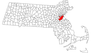
This is a list of the National Register of Historic Places listings in Suffolk County, Massachusetts.
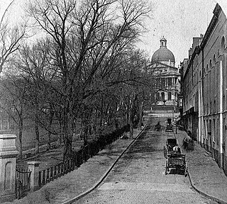
Park Street is a short but historic road in the center of Boston, Massachusetts. It begins at the top of Beacon Hill, at the intersection of Beacon Street, where it is lined up with the front of the Massachusetts State House. It then spills down the hill toward Tremont Street, with Boston Common to its west.

Tremont Street is a major thoroughfare in Boston, Massachusetts.

The Shirley–Eustis House is a historic house located at 33 Shirley Street, Boston, Massachusetts. It is a U.S. National Historic Landmark.

Downtown Boston is the central business district of Boston, Massachusetts, United States. Boston was founded in 1630. The largest of the city's commercial districts, Downtown is the location of many corporate or regional headquarters; city, county, state and federal government facilities; and many of Boston's tourist attractions. Similar to other central business districts in the U.S., Downtown has recently undergone a transformation that included the construction of new condos and lofts, renovation of historic buildings, and arrival of new residents and businesses. It is represented in the Boston City Council by District 2's Bill Linehan.

The Common District encompasses the main civic center of Wakefield, Massachusetts. It is centered on the historic town common, just south of Lake Quannapowitt, which was laid in 1644, when it became the heart of Old Reading. The area was separated from Reading as South Reading in 1818, and renamed Wakefield in 1868. The 25 acre district includes the buildings that line the common on Common Street and Main Street, which include the town hall, public library, YMCA, post office, and several churches. It was listed on the National Register of Historic Places in 1990.
Boston, Massachusetts is home to many listings on the National Register of Historic Places. This list encompasses those locations that are located north of the Massachusetts Turnpike. See National Register of Historic Places listings in southern Boston for listings south of the Turnpike. Properties and districts located elsewhere in Suffolk County's other three municipalities are also listed separately.
Boston, Massachusetts is home to many listings on the National Register of Historic Places. This list encompasses those locations that are located south of the Massachusetts Turnpike. See National Register of Historic Places listings in northern Boston for listings north of the Turnpike. Properties and districts located elsewhere in Suffolk County's other three municipalities are also listed separately.

Fort Hill is a 0.4 square mile neighborhood and historic district of Roxbury, in Boston, Massachusetts. The approximate boundaries of Fort Hill are Malcolm X Boulevard on the north, Washington Street on the southeast, and Columbus Avenue on the southwest.