Parkland, Wisconsin

Last updated
Parkland, Wisconsin
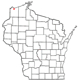
WIMap-doton-Parkland.png
Location of Parkland, Wisconsin
Coordinates: 46°37′49″N91°59′22″W / 46.63028°N 91.98944°W / 46.63028; -91.98944
Country Flag of the United States.svg  United States
State Flag of Wisconsin.svg  Wisconsin
County Douglas
Area
  Total35.5 sq mi (92.0 km2)
  Land35.5 sq mi (92.0 km2)
  Water0.0 sq mi (0.0 km2)
Elevation
[1]
728 ft (222 m)
Population
 (2000)
  Total1,240
  Density34.9/sq mi (13.5/km2)
Time zone UTC-6 (Central (CST))
  Summer (DST) UTC-5 (CDT)
Area code(s) 715 and 534
FIPS code 55-61250 [2]
GNIS feature ID1583896 [1]

Parkland is a town in Douglas County, Wisconsin, United States. The population was 1,240 at the 2000 census. The unincorporated communities of Cutter, Parkland, Peyton, South Itasca, Sunnyside and South Range are in the town.

Contents

Geography

According to the United States Census Bureau, the town has a total area of 35.5 square miles (91.9 km2), all of it land.

The Town of Parkland is located south of the city of Superior. Parkland Town Hall is in the unincorporated community of South Range, Wisconsin.

Demographics

As of the census [2] of 2000, there were 1,240 people, 463 households, and 363 families living in the town. The population density was 34.9 people per square mile (13.5/km2). There were 480 housing units at an average density of 13.5 per square mile (5.2/km2). The racial makeup of the town was 97.02% White, 0.16% African American, 1.05% Native American, 0.40% Asian, 0.16% from other races, and 1.21% from two or more races. Hispanic or Latino of any race were 1.05% of the population.

There were 463 households, out of which 34.6% had children under the age of 18 living with them, 66.5% were married couples living together, 7.3% had a female householder with no husband present, and 21.4% were non-families. 16.4% of all households were made up of individuals, and 5.2% had someone living alone who was 65 years of age or older. The average household size was 2.68 and the average family size was 2.98.

In the town, the population was spread out, with 25.6% under the age of 18, 7.1% from 18 to 24, 28.8% from 25 to 44, 26.2% from 45 to 64, and 12.3% who were 65 years of age or older. The median age was 39 years. For every 100 females, there were 101.0 males. For every 100 females age 18 and over, there were 102.2 males.

The median income for a household in the town was $40,804, and the median income for a family was $43,375. Males had a median income of $34,318 versus $21,141 for females. The per capita income for the town was $17,090. About 3.9% of families and 4.7% of the population were below the poverty line, including 4.4% of those under age 18 and 5.5% of those age 65 or over.

Transportation

County Road E, County Road Z, State Highway 13, County Road K, and U.S. Route 2 / U.S. Route 53 (co-signed) are five of the main routes in the community.

Education

The Superior School District serves the town. It has six elementary schools, one middle school, and one high school.

Coordinates: 46°38′52″N91°59′52″W / 46.64778°N 91.99778°W / 46.64778; -91.99778

Related Research Articles

<span class="mw-page-title-main">Munising, Michigan</span> City in Michigan, United States

Munising is a city in Alger County in the U.S. state of Michigan. The population was 2,355 at the 2010 census. It is the county seat of Alger County. The city is partially surrounded by Munising Township, but the two are administered autonomously.

<span class="mw-page-title-main">Atwater, Minnesota</span> City in Minnesota, United States

Atwater is a city in Kandiyohi County, Minnesota, United States. The population was 1,124 at the 2020 census.

<span class="mw-page-title-main">Curryville, Missouri</span> City in Missouri, United States

Curryville is a city in western Pike County, Missouri, United States. The population was 225 at the 2010 census.

Morrisville is a village in Madison County, New York, United States. The population was 2,199 at the 2010 census. The village is named after its founder, Thomas Morris.

<span class="mw-page-title-main">North Whitehall Township, Lehigh County, Pennsylvania</span> Township in Pennsylvania, United States

North Whitehall Township is a township in Lehigh County, Pennsylvania. The population of North Whitehall Township was 15,655 at the 2020 census. It is a suburb of Allentown in the Lehigh Valley, which had a population of 861,899 and was the 68th most populous metropolitan area in the U.S. as of the 2020 census.

<span class="mw-page-title-main">Tatum, South Carolina</span> Town in South Carolina, United States

Tatum is a town in Marlboro County, South Carolina, United States. The population was 75 at the 2010 census.

<span class="mw-page-title-main">Waterville, Washington</span> Town in Washington, United States

Waterville is a town in and the county seat of Douglas County, Washington, United States which is known for its wheat industry. As a part of Douglas County, it is part of the Wenatchee-East Wenatchee metropolitan area. The population was 1,134 at the 2020 census.

<span class="mw-page-title-main">Cable, Wisconsin</span> Town in Wisconsin, United States

Cable is a town in Bayfield County, Wisconsin, United States. Its population was 825 at the 2010 U.S. census. The census-designated place of Cable and the unincorporated communities of Leonards and Radspur are located in the town.

<span class="mw-page-title-main">Delta, Wisconsin</span> Town in Wisconsin, United States

Delta is a town in Bayfield County, Wisconsin, United States. The population was 273 at the 2010 census. The unincorporated communities of Delta and Pike River are located in the town. The unincorporated community of Sutherland is located partially in the town.

<span class="mw-page-title-main">Drummond, Wisconsin</span> Census-designated place in Wisconsin, United States

Drummond is a town in Bayfield County, Wisconsin, United States. The population was 169 at the 2020 census, down from 463 at the 2010 census. The census-designated place of Drummond is located in the town. The unincorporated community of Lake Owen is also located in the town.

<span class="mw-page-title-main">Courtland, Wisconsin</span> Town in Wisconsin, United States

Courtland is a town in Columbia County, Wisconsin in the United States. The population was 463 at the 2000 census.

<span class="mw-page-title-main">Bennett, Wisconsin</span> Town in Wisconsin, United States

Bennett is a town in Douglas County, Wisconsin, United States. The population was 597 at the 2010 census. The unincorporated communities of Beebe and Bennett are located in the town.

<span class="mw-page-title-main">Cloverland, Douglas County, Wisconsin</span> Town in Wisconsin, United States

Cloverland is a town in Douglas County, Wisconsin, United States. The population was 247 at the 2000 census. The unincorporated community of Cloverland is located in the town.

<span class="mw-page-title-main">Hawthorne, Wisconsin</span> Town in Wisconsin, United States

Hawthorne is a town in Douglas County, Wisconsin, United States. The population was 1,045 at the 2000 census. The unincorporated communities of Dobie, Hawthorne, Hillcrest, and Hines are located in the town.

<span class="mw-page-title-main">Maple, Wisconsin</span> Town in Wisconsin, United States

Maple is a town in Douglas County, Wisconsin, United States. The population was 649 at the 2000 census. The unincorporated communities of Blueberry and Maple are located in the town.

<span class="mw-page-title-main">Clarno, Wisconsin</span> Town in Wisconsin, United States

Clarno is a town in Green County, Wisconsin, United States. The population was 1,079 at the 2000 census. The unincorporated communities of Clarno and Schneyville are located in the town.

<span class="mw-page-title-main">Fabius, New York</span> Town in New York, United States

Fabius is a town in Onondaga County, New York, United States. The population was 1,964 at the 2010 census. The classical name of the town was assigned by a clerk interested in the classics.

Mason is a town in Bayfield County, Wisconsin, United States. The population was 315 at the 2010 census. The Village of Mason is located within the town. The unincorporated community of Sutherland is located partially in the town.

Solon Springs is a town in Douglas County, Wisconsin, United States. As of the 2010 census, the town had a total population of 910. The Village of Solon Springs is located within the town. The unincorporated community of Sauntry is also located in the town.

Minong is a town in Washburn County, Wisconsin, United States. The population was 858 at the 2000 census. The Village of Minong is located within the town.

References

  1. 1 2 "US Board on Geographic Names". United States Geological Survey. 2007-10-25. Retrieved 2008-01-31.
  2. 1 2 "U.S. Census website". United States Census Bureau . Retrieved 2008-01-31.