Poplar, Wisconsin | |
---|---|
Coordinates: 46°34′55″N91°47′37″W / 46.58194°N 91.79361°W | |
Country | United States |
State | Wisconsin |
County | Douglas |
Area | |
• Total | 11.91 sq mi (30.84 km2) |
• Land | 11.88 sq mi (30.77 km2) |
• Water | 0.03 sq mi (0.08 km2) |
Elevation | 981 ft (299 m) |
Population | |
• Total | 603 |
• Estimate (2019) [4] | 603 |
• Density | 50.77/sq mi (19.60/km2) |
Time zone | UTC-6 (Central (CST)) |
• Summer (DST) | UTC-5 (CDT) |
ZIP codes | 54864 |
Area code(s) | 715 and 534 |
FIPS code | 55-63975 [5] |
GNIS feature ID | 1571768 [2] |
Website | www.villageofpoplar.com |
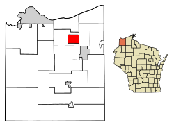
Poplar is a village in Douglas County, Wisconsin, United States. The population was 603 at the 2010 census.
U.S. Highway 2, County Road D, and County Road P are the main routes in the community.
Poplar is located at 46°34′55″N91°47′37″W / 46.58194°N 91.79361°W (46.582014, -91.793712). [6]
According to the United States Census Bureau, the village has a total area of 11.93 square miles (30.90 km2), of which, 11.90 square miles (30.82 km2) of it is land and 0.03 square miles (0.08 km2) is water. [7]
Poplar is located 18 miles east of the city of Superior.
Census | Pop. | Note | %± |
---|---|---|---|
1920 | 357 | — | |
1930 | 449 | 25.8% | |
1940 | 462 | 2.9% | |
1950 | 489 | 5.8% | |
1960 | 475 | −2.9% | |
1970 | 455 | −4.2% | |
1980 | 569 | 25.1% | |
1990 | 516 | −9.3% | |
2000 | 552 | 7.0% | |
2010 | 603 | 9.2% | |
2019 (est.) | 603 | [4] | 0.0% |
U.S. Decennial Census [8] |
As of the census [3] of 2010, there were 603 people, 229 households, and 172 families living in the village. The population density was 50.7 inhabitants per square mile (19.6/km2). There were 254 housing units at an average density of 21.3 per square mile (8.2/km2). The racial makeup of the village was 94.5% White, 0.3% African American, 1.7% Native American, 1.2% Asian, 0.2% from other races, and 2.2% from two or more races.
There were 229 households, of which 37.1% had children under the age of 18 living with them, 59.8% were married couples living together, 9.2% had a female householder with no husband present, 6.1% had a male householder with no wife present, and 24.9% were non-families. 18.8% of all households were made up of individuals, and 9.6% had someone living alone who was 65 years of age or older. The average household size was 2.63 and the average family size was 2.91.
The median age in the village was 39 years. 26.9% of residents were under the age of 18; 6.7% were between the ages of 18 and 24; 24.8% were from 25 to 44; 25.9% were from 45 to 64; and 15.6% were 65 years of age or older. The gender makeup of the village was 49.6% male and 50.4% female.
As of the census [5] of 2000, there were 552 people, 209 households, and 152 families living in the village. The population density was 46.3 people per square mile (17.9/km2). There were 222 housing units at an average density of 18.6 per square mile (7.2/km2). The racial makeup of the village was 98.37% White, 1.27% Native American, and 0.36% from two or more races. Hispanic or Latino of any race were 0.36% of the population.
There were 209 households, out of which 34.0% had children under the age of 18 living with them, 68.4% were married couples living together, 2.4% had a female householder with no husband present, and 26.8% were non-families. 22.5% of all households were made up of individuals, and 9.6% had someone living alone who was 65 years of age or older. The average household size was 2.64 and the average family size was 3.14.
In the village, the population was spread out, with 29.3% under the age of 18, 3.8% from 18 to 24, 28.3% from 25 to 44, 25.4% from 45 to 64, and 13.2% who were 65 years of age or older. The median age was 39 years. For every 100 females, there were 100.0 males. For every 100 females age 18 and over, there were 100.0 males.
The median income for a household in the village was $41,406, and the median income for a family was $51,406. Males had a median income of $40,893 versus $21,154 for females. The per capita income for the village was $18,218. About 6.3% of families and 8.7% of the population were below the poverty line, including 6.5% of those under age 18 and 14.3% of those age 65 or over.
The Maple School District serves Poplar. Northwestern Elementary School and Northwestern Middle School are in Poplar. Northwestern High School is in neighboring Maple.
East Oakdale is an unincorporated census-designated place (CDP) on the Stanislaus River, located east of the city of Oakdale in Stanislaus County, California.
Poplar-Cotton Center is a census-designated place (CDP) in Tulare County, California, United States. The population was 2,470 at the 2010 census, up from 1,496 at the 2000 census.
Pawnee is a village in Sangamon County, Illinois, United States. Its population was 2,739 at the 2010 census, and 2,651 at a 2018 estimate. It is part of the Springfield, Illinois, Metropolitan Statistical Area.
Forest Hills is a home rule-class city in Jefferson County, Kentucky, United States. It was formally incorporated by the state assembly in 1959. The population was 444 at the 2010 census.
Poplar Hills is a home rule-class city in Jefferson County, Kentucky, United States. It is a part of the Louisville Metro government, but operates as a city under the Mayor to Commissioner form of government. Per the 2020 census, the population was 380, but the city administration has made several annexation ordinances that have passed and awaits updated information. The current city population is estimated to be 380. It currently has the highest population density for any city in Kentucky.
Aurelius Township is a civil township of Ingham County in the U.S. state of Michigan. As of the 2020 census, the township population was 4,354, a significant increase from 3,525 at the 2010 census.
Poplar Township is a township in Cass County, Minnesota, United States. The population was 173 as of the 2000 census. Poplar Township was named from the groves of poplar trees within its borders.
Innsbrook is a village in Warren County, Missouri, United States. The population was 552 at the 2010 census. The village of Innsbrook is comprised almost entirely by Innsbrook Resort—a private, gated community. The village was founded in 1998.
Ismay is a town in Custer County, Montana, United States. There is a post office at Ismay, and a church, and no other businesses or services. The population was 17 at the 2020 census. The town is the least-populous incorporated municipality in the state of Montana.
Ottoville is a village in Putnam County, Ohio, in the United States. The population was 966 at the 2020 census.
Harpster is a village in Wyandot County, Ohio, United States. The population was 160 at the 2020 census.
Lanesboro is a borough in Susquehanna County, Pennsylvania, United States. The population was 485 at the 2020 census.
Windsor Heights is a village in Brooke County, West Virginia, United States. It is part of the Wheeling, West Virginia Metropolitan Statistical Area. The population was 423 at the 2010 census. Grace Davis was the mayor as of June 2017.
Ridgeland is a village in Dunn County, Wisconsin, United States. The population was 258 at the 2021 census.
Wheeler is a village in Dunn County, Wisconsin, United States, along the Hay River. The population was 348 at the 2010 census.
North Bay is a village in Racine County, Wisconsin, United States. The population was 209 at the 2020 census.
Weyerhaeuser is a village in Rusk County, Wisconsin, United States. The population was 238 at the 2010 census.
Exeland is a village in Sawyer County, Wisconsin, United States. The population was 229 at the 2020 census.
Dallas is a village in Barron County in the U.S. state of Wisconsin. The population was 409 at the 2010 census. The village is located within the Town of Dallas.
Mason is a village in Bayfield County, Wisconsin, United States. The population was 93 at the 2010 census. The village is located within the Town of Mason.