Superior (village), Wisconsin

Last updated
Village of Superior
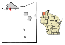
Douglas County Wisconsin Incorporated and Unincorporated areas Superior Highlighted 5578660.svg
Location of the Village of Superior
in Douglas County, Wisconsin
USA Wisconsin location map.svg
Red pog.svg
Village of Superior
Location of the Village of Superior
in Douglas County, Wisconsin
Coordinates: 46°39′22″N92°6′13″W / 46.65611°N 92.10361°W / 46.65611; -92.10361 Coordinates: 46°39′22″N92°6′13″W / 46.65611°N 92.10361°W / 46.65611; -92.10361
Country Flag of the United States.svg  United States
State Flag of Wisconsin.svg  Wisconsin
County Douglas
Area
[1]
  Total1.25 sq mi (3.23 km2)
  Land1.24 sq mi (3.22 km2)
  Water0.01 sq mi (0.01 km2)
Population
 (2010) [2]
  Total664
  Estimate 
(2019) [3]
705
  Density567.63/sq mi (219.16/km2)
Time zone UTC-6 (Central (CST))
  Summer (DST) UTC-5 (CDT)
Area code(s) 715 and 534
FIPS code 55-78660 [4]
Website www.villageofsuperior.org

The Village of Superior is a village in Douglas County, Wisconsin, United States. The population was 664 at the 2010 census. The village is located within the Town of Superior and is located immediately south of and adjacent to the City of Superior.

Contents

Transportation

Wisconsin Highway 35 (Tower Avenue) serves as a main route in the village.

Geography

Superior is located at 46°39′22″N92°6′13″W / 46.65611°N 92.10361°W / 46.65611; -92.10361 (46.65614, -92.103638). [5]

According to the United States Census Bureau, the village has a total area of 1.24 square miles (3.21 km2), of which, 1.23 square miles (3.19 km2) of it is land and 0.01 square miles (0.03 km2) is water. [6]

Demographics

Historical population
CensusPop.
1950 339
1960 37410.3%
1970 47627.3%
1980 58021.8%
1990 481−17.1%
2000 5004.0%
2010 66432.8%
2019 (est.)705 [3] 6.2%
U.S. Decennial Census [7]

2010 census

As of the census [2] of 2010, there were 664 people, 299 households, and 194 families living in the village. The population density was 539.8 inhabitants per square mile (208.4/km2). There were 309 housing units at an average density of 251.2 per square mile (97.0/km2). The racial makeup of the village was 97.0% White, 0.2% African American, 1.1% Native American, 0.3% Asian, 0.2% from other races, and 1.4% from two or more races. Hispanic or Latino of any race were 1.1% of the population.

There were 299 households, of which 28.8% had children under the age of 18 living with them, 51.5% were married couples living together, 9.0% had a female householder with no husband present, 4.3% had a male householder with no wife present, and 35.1% were non-families. 30.8% of all households were made up of individuals, and 18% had someone living alone who was 65 years of age or older. The average household size was 2.22 and the average family size was 2.73.

The median age in the village was 47.1 years. 20.5% of residents were under the age of 18; 4.7% were between the ages of 18 and 24; 21.2% were from 25 to 44; 33.1% were from 45 to 64; and 20.5% were 65 years of age or older. The gender makeup of the village was 48.2% male and 51.8% female.

2000 census

As of the census [4] of 2000, there were 500 people, 209 households, and 158 families living in the village. The population density was 404.7 people per square mile (155.7/km2). There were 210 housing units at an average density of 170.0/sq mi (65.4/km2). The racial makeup of the village was 96.80% White, 0.60% Black or African American, 1.00% Native American, 1.20% Asian, 0.20% from other races, and 0.20% from two or more races. 0.20% of the population were Hispanic or Latino of any race. 17.1% were of German, 15.1% Swedish, 11.4% Norwegian, 11.1% Polish, 10.3% Finnish, 7.1% Irish and 6.0% French ancestry according to Census 2000.

There were 209 households, out of which 30.6% had children under the age of 18 living with them, 63.2% were married couples living together, 10.0% had a female householder with no husband present, and 24.4% were non-families. 20.6% of all households were made up of individuals, and 11.0% had someone living alone who was 65 years of age or older. The average household size was 2.39 and the average family size was 2.76.

In the village, the population was spread out, with 21.0% under the age of 18, 8.4% from 18 to 24, 25.4% from 25 to 44, 28.6% from 45 to 64, and 16.6% who were 65 years of age or older. The median age was 43 years. For every 100 females, there were 94.6 males. For every 100 females age 18 and over, there were 98.5 males.

The median income for a household in the village was $60,092, and the median income for a family was $72,385. Males had a median income of $59,722 versus $15,625 for females. The per capita income for the village was $39,328. About 0.7% of families and 0.8% of the population were below the poverty line, including none of those under the age of eighteen or sixty-five or over.
Related Research Articles

Hartford, Alabama City in Alabama, United States

Hartford is a city in Geneva County, Alabama, United States. It incorporated in 1896. It is part of the Dothan, Alabama Metropolitan Statistical Area. At the 2010 census the population was 2,624, up from 2,369 in 2000.

Shageluk, Alaska City in Alaska, United States

Shageluk is a city in Yukon-Koyukuk Census Area, Alaska, United States. At the 2010 census the population was 83, down from 129 in 2000.

Scottville, Illinois Village in Illinois, United States

Scottville is a village in Macoupin County, Illinois, United States. The population was 140 at the 2000 census.

Poneto, Indiana Town in Indiana, United States

Poneto is a town in Chester, Harrison and Liberty townships, Wells County, in the U.S. state of Indiana. The population was 166 at the 2010 census.

Hansell, Iowa City in Iowa, United States

Hansell is a city in Franklin County, Iowa, United States. The population was 98 at the 2010 census.

Fort Polk North, Louisiana Census-designated place in Louisiana, United States

Fort Polk North is a census-designated place (CDP) in Vernon Parish, Louisiana, United States. The population was 3,279 at the 2000 census. It is part of the Fort Polk South Micropolitan Statistical Area.

Clear Spring, Maryland Town in Maryland, United States

Clear Spring is a town in Washington County, Maryland, United States. The population was 358 at the 2010 census.

Wheeling Township, Rice County, Minnesota Township in Minnesota, United States

Wheeling Township is a township in Rice County, Minnesota, United States. The population was 541 at the 2000 census.

Climax Springs, Missouri Census-designated place in Missouri, United States

Climax Springs was a village in Camden County, Missouri, United States. The population was 124 at the 2010 census.

Turpin Hills, Ohio Census-designated place in Ohio, United States

Turpin Hills is a census-designated place (CDP) outside of Anderson Township, Hamilton County, Ohio, United States. The population was 5,099 at the 2010 census.

Jackson Township, Butler County, Pennsylvania Township in Pennsylvania, United States

Jackson Township is a township in Butler County, Pennsylvania, United States. The population was 3,657 at the 2010 census.

La Plant, South Dakota Census-designated place in South Dakota, United States

La Plant is a census-designated place (CDP) in Dewey County, South Dakota, United States. The population was 171 at the 2010 census. It is within the Cheyenne River Indian Reservation.

Liberty Lake, Washington City in Washington, United States

Liberty Lake is a city in Spokane County, Washington, United States located adjacent to the eponymous lake. Located just over a mile west of the Washington–Idaho border, Liberty Lake is both a suburb of Spokane, Washington and a bedroom community to Coeur d'Alene, Idaho. The population was 7,591 at the 2010 census.

Bethlehem, West Virginia Village in West Virginia, United States

Bethlehem is a village in Ohio County, West Virginia, United States. It is part of the Wheeling, West Virginia Metropolitan Statistical Area. The population was 2,499 at the 2010 census.

Colburn, Adams County, Wisconsin Town in Wisconsin, United States

Colburn is a town in Adams County in the U.S. state of Wisconsin. The population was 223 at the 2010 census. The town was most likely named for Sherman Colburn, who immigrated to Wisconsin from Vermont in 1855 and became a farmer in the area.

Sherwood, Wisconsin Village in Wisconsin, United States

Sherwood is a village in Calumet County, Wisconsin, United States. The population was 2,713 at the 2010 census. The former historical unincorporated community of High Cliff is located within present-day Sherwood.

Oliver, Wisconsin Village in Wisconsin, United States

Oliver is a village in Douglas County, Wisconsin, United States. The population was 399 at the 2010 census.

Poplar, Wisconsin Village in Wisconsin, United States

Poplar is a village in Douglas County, Wisconsin, United States. The population was 603 at the 2010 census.

Highland, Wisconsin Village in Wisconsin, United States

Highland is a village in Iowa County, Wisconsin, United States. The population was 842 at the 2010 census. It is part of the Madison Metropolitan Statistical Area. The village is located within the Town of Highland.

Aniwa, Wisconsin Village in Wisconsin, United States

Aniwa is a village in Shawano County, Wisconsin, United States. The population was 260 at the 2010 census. The village is located within the Town of Aniwa. U.S. Route 45 runs north-south through the village.

References

  1. "2019 U.S. Gazetteer Files". United States Census Bureau. Retrieved August 7, 2020.
  2. 1 2 "U.S. Census website". United States Census Bureau . Retrieved 2012-11-18.
  3. 1 2 "Population and Housing Unit Estimates". United States Census Bureau. May 24, 2020. Retrieved May 27, 2020.
  4. 1 2 "U.S. Census website". United States Census Bureau . Retrieved 2008-01-31.
  5. "US Gazetteer files: 2010, 2000, and 1990". United States Census Bureau. 2011-02-12. Retrieved 2011-04-23.
  6. "US Gazetteer files 2010". United States Census Bureau. Archived from the original on 2011-02-20. Retrieved 2012-11-18.
  7. "Census of Population and Housing". Census.gov. Retrieved June 4, 2015.