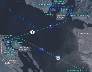
Bowen Island, British Columbia, is an island municipality that is part of Metro Vancouver. Bowen Island is within the jurisdiction of the Islands Trust. Located in Howe Sound, it is approximately 6 kilometres (3.7 mi) wide by 12 kilometres (7.5 mi) long, with the island at its closest point about 3 kilometres (1.9 mi) west of the mainland. There is regular ferry service from Horseshoe Bay provided by BC Ferries, as well as semi-regular water taxi services. The population of 4,256 is supplemented in the summer by roughly 1,500 visitors, as Bowen Island regularly receives travelers in the summer season. The island has a land area of 50.12 km2 (19.35 sq mi).

Nanaimo is a city on the east coast of Vancouver Island, in British Columbia, Canada. As of the 2021 census, it had a population of 99,863, and it is known as "The Harbour City." The city was previously known as the "Hub City," which was attributed to its original layout design, whose streets radiated from the shoreline like the spokes of a wagon wheel, and to its central location on Vancouver Island. Nanaimo is the headquarters of the Regional District of Nanaimo.

West Vancouver is a district municipality in the province of British Columbia, Canada. A member municipality of the Metro Vancouver Regional District, West Vancouver is to the northwest of the city of Vancouver on the northern side of English Bay and the southeast shore of Howe Sound, and is adjoined by the District of North Vancouver to its east. Together with the District of North Vancouver and the City of North Vancouver, it is part of a local regional grouping referred to as the North Shore municipalities, or simply "the North Shore".

Pender Island is one of the Southern Gulf Islands located in the Gulf of Georgia, British Columbia, Canada. Pender Island is approximately 34 km2 (13 sq mi) in area and is home to about 2,250 permanent residents, as well as a large seasonal population. Like most of the rest of the Southern Gulf Islands, Pender Island enjoys a sub-Mediterranean climate and features open farmland, rolling forested hills, several lakes and small mountains, as well as many coves and beaches.

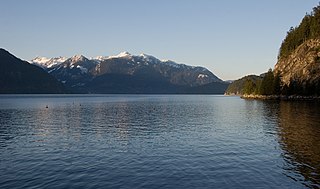
Howe Sound is a roughly triangular sound, that joins a network of fjords situated immediately northwest of Vancouver, British Columbia.
Seymour Inlet is one of the lesser travelled of the principal inlets of the British Columbia Coast. Unlike larger inlets such as Knight or Bute, it is not flanked by mountains but by relatively low, but still rugged, coastal hill-country and forms a maze of complex, narrow waterways and tidal pools and lagoons. It is located within a corresponding maze of peninsulas on the mainland on the northwest side of the Queen Charlotte Strait region.

Vargas Island Provincial Park is a provincial park in British Columbia, Canada, comprising the west side of the island of the same name, which is located west of Meares Island and northwest of the resort community of Tofino in the Clayoquot Sound region of the West Coast of Vancouver Island, British Columbia, Canada. The park was created as part of the Clayoquot Land-Use Decision on July 13, 1995 and contains 5,805 hectares, 1,543 hectares of it being upland and 4,262 hectares being foreshore. Also located on Vargas Island, on its north side, is Epper Passage Provincial Park.
Wallace Island Marine Provincial Park is a provincial park in the Gulf Islands of British Columbia, Canada. The park includes almost all 72 hectares of Wallace Island. Land on the northern side of Princess Cove extending north towards Chivers is private. This long, thin island lies in Trincomali Channel south-west of Galiano Island, and about 2 km (1.2 mi) northeast of Saltspring Island. There are a few hiking trails, and camping is permitted in designated areas.

Seymour Narrows is a 5-kilometre (3.1 mi) section of the Discovery Passage in British Columbia known for strong tidal currents. Discovery Passage lies between Vancouver Island at Menzies Bay, British Columbia and Quadra Island except at its northern end where the eastern shoreline is Sonora Island. The section known as Seymour Narrows begins about 18 km (11 mi) from the south end of Discovery Passage where it enters the Georgia Strait near Campbell River. For most of the length of the narrows, the channel is about 750 metres (820 yd) wide. Through this narrow channel, currents can reach 15 knots.

De Courcy Island is one of the Gulf Islands located between Pylades and Stuart Channels approximately 16 km (9.9 mi) south-east of Nanaimo, British Columbia and approximately 38 km (24 mi) south-west of Vancouver, British Columbia. The island was named after Michael de Courcy, captain of HMS Pylades and is about 460 acres (186.2 ha) in area.

Cortes Island is an island in the Discovery Islands archipelago on the coast of British Columbia, Canada. The island is 25 km (16 mi) long, 13 km (8 mi) wide, and 130 km2 (50 sq mi) in area. It has a population of 1,035 permanent residents. Cortes Island lies within Electoral Area B of the Strathcona Regional District, which provides water and sewerage systems, fire protection, land use planning, parks, recreation, and emergency response.
Gambier Island is an island located in Howe Sound near Vancouver, British Columbia. It is about 17,049 acres in size and is located about 10 kilometres north of the Horseshoe Bay community and ferry terminal in westernmost West Vancouver.

Lund is a small craft harbour and unincorporated village on Tla'amin land in qathet Regional District, British Columbia, Canada. It is along the northern part of the Salish Sea on the mainland BC coast. The main landmark in the village is the Lund Hotel, established in 1905. By boat from Lund, the Copeland Islands and Desolation Sound, are nearby. Lund is home to many shops and services including a general store, a restaurant overlooking the water, kayak and adventure tourism stores, and Nancy's Bakery, a favourite of locals and tourists.

Milbanke Sound is a sound on the coast of the Canadian province of British Columbia.

Keats Island is an inhabited island located in Howe Sound near Vancouver, British Columbia. Around eighty people live on Keats Island year-round.

Princess Louisa Inlet on the British Columbia Coast is 6 km (3.7 mi) in length and lies at the north east end of Jervis Inlet. It is entered through Malibu Rapids off Queens Reach past Malibu, a former private resort and now youth camp. A portion of the area that makes up Princess Louisa Marine Provincial Park. James Bruce Falls and Chatterbox Falls are on Loquilts Creek, a large stream that enters the head of the inlet.

Portland Island is an island of the Southern Gulf Islands of the South Coast of British Columbia, Canada. It is located in the Salish Sea west of Moresby Island and off the south tip of Saltspring Island, adjacent to the main BC Ferries route just offshore from the terminal at Swartz Bay at the tip of the Saanich Peninsula. It was named after HMS Portland, the flagship of Rear-Admiral Fairfax Moresby, Commander in Chief of the Pacific Station 1850–1853.

Port Mellon is a settlement in British Columbia and part of West Howe Sound, Electoral Area F within the Sunshine Coast Regional District (SCRD) in British Columbia, Canada. Port Mellon is the home to the biggest employer of the area, the Howe Sound Pulp and Paper Mill. Most amenities of the area are a short drive away in Gibsons. For longer trips there is the Langdale ferry terminal to Vancouver. Nearby Tetrahedron Provincial Park is a popular location for day hikes and mountain biking.

Lady Alexandra was a steamship built in 1924 in Montrose, Scotland which served in British Columbia from 1924 to 1952, mostly on Howe Sound.

The Bowen Island ferry travels between Snug Cove on Bowen Island, and Horseshoe Bay in the District of West Vancouver, British Columbia, Canada, a trip of three nautical miles across Howe Sound. A scheduled ferry has been in operation since 1921, when Bowen Island was a popular holiday destination. Prior to that year, transportation to the island was by steamship from Vancouver, with only one trip daily. The Bowen Island ferry used a fleet of small passenger vessels until 1956, when a single car ferry began passenger service, and that ferry began carrying vehicles in 1958. In 2021 the route carried in excess of 1 million passengers plus 500,000 vehicles.


