Paul, Idaho

Last updated
Paul, Idaho
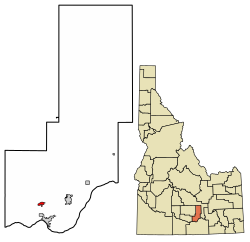
Minidoka County Idaho Incorporated and Unincorporated areas Paul Highlighted 1661210.svg
Location in Minidoka County, Idaho
Coordinates: 42°36′23″N113°47′0″W / 42.60639°N 113.78333°W / 42.60639; -113.78333 Coordinates: 42°36′23″N113°47′0″W / 42.60639°N 113.78333°W / 42.60639; -113.78333
Country United States
State Idaho
County Minidoka
Area
[1]
  Total0.69 sq mi (1.78 km2)
  Land0.66 sq mi (1.71 km2)
  Water0.03 sq mi (0.07 km2)
Elevation
4,150 ft (1,260 m)
Population
 (2020) [2]
  Total1,195
  Density1,813.4/sq mi (700.2/km2)
Time zone UTC-7 (Mountain (MST))
  Summer (DST) UTC-6 (MDT)
ZIP code
83347
Area code(s) 208, 986
FIPS code 16-61210
GNIS feature ID0397012
Website cityofpaul.org

Paul is a city in Minidoka County, Idaho, founded in 1907. The population was 1,195 at the 2020 census. [2] It is part of the Burley, Idaho Micropolitan Statistical Area. The town received its name from Charles H. Paul, an engineer who worked on the Minidoka Project.

Contents

Geography

Paul is in southern Minidoka County, 6 miles (10 km) west of Rupert, the county seat, and 5 miles (8 km) north of Burley. Idaho State Highway 25 passes east-west through the city, and State Highway 27 leads south from the city center.

According to the United States Census Bureau, Paul has a total area of 0.69 square miles (1.79 km2), of which 0.03 square miles (0.08 km2), or 4.08%, are water. [1]

Demographics

Historical population
CensusPop.
1920 527
1930 363−31.1%
1940 60666.9%
1950 560−7.6%
1960 70125.2%
1970 91130.0%
1980 9403.2%
1990 901−4.1%
2000 99810.8%
2010 1,16917.1%
2020 1,1952.2%
U.S. Decennial Census [3]

2010 census

As of the census [4] of 2010, there were 1,169 people, 446 households, and 311 families residing in the city. The population density was 1,826.6 inhabitants per square mile (705.3/km2). There were 473 housing units at an average density of 739.1 per square mile (285.4/km2). The racial makeup of the city was 76.6% White, 0.9% Native American, 0.8% Asian, 18.0% from other races, and 3.6% from two or more races. Hispanic or Latino of any race were 28.5% of the population.

There were 446 households, of which 34.3% had children under the age of 18 living with them, 56.7% were married couples living together, 7.4% had a female householder with no husband present, 5.6% had a male householder with no wife present, and 30.3% were non-families. 26.7% of all households were made up of individuals, and 13.9% had someone living alone who was 65 years of age or older. The average household size was 2.62 and the average family size was 3.20.

The median age in the city was 34.3 years. 28.7% of residents were under the age of 18; 7.2% were between the ages of 18 and 24; 24.7% were from 25 to 44; 23.5% were from 45 to 64; and 16% were 65 years of age or older. The gender makeup of the city was 51.3% male and 48.7% female.

2000 census

As of the census [5] of 2000, there were 998 people, 409 households, and 276 families residing in the city. The population density was 1,559.4 inhabitants per square mile (602.1/km2). There were 430 housing units at an average density of 671.9 per square mile (259.4/km2). The racial makeup of the city was 83.27% White, 0.10% African American, 0.80% Native American, 0.40% Asian, 12.22% from other races, and 3.21% from two or more races. Hispanic or Latino of any race were 16.33% of the population.

There were 409 households, out of which 31.3% had children under the age of 18 living with them, 54.0% were married couples living together, 8.6% had a female householder with no husband present, and 32.3% were non-families. 28.4% of all households were made up of individuals, and 17.6% had someone living alone who was 65 years of age or older. The average household size was 2.44 and the average family size was 2.99.

In the city, the population was spread out, with 27.3% under the age of 18, 7.3% from 18 to 24, 24.7% from 25 to 44, 22.2% from 45 to 64, and 18.4% who were 65 years of age or older. The median age was 39 years. For every 100 females, there were 94.9 males. For every 100 females age 18 and over, there were 90.1 males.

The median income for a household in the city was $30,417, and the median income for a family was $35,179. Males had a median income of $33,375 versus $21,172 for females. The per capita income for the city was $15,627. About 9.8% of families and 14.6% of the population were below the poverty line, including 19.3% of those under age 18 and 9.7% of those age 65 or over.
Education

Paul is served by the Minidoka County Schools system.

Students are zoned to:

See also

Related Research Articles

<span class="mw-page-title-main">Power County, Idaho</span> County in Idaho, United States

Power County is a county located in the U.S. state of Idaho. As of the 2010 Census, the county had a population of 7,817. The county seat and largest city is American Falls. The county was created by the Idaho Legislature on January 30, 1913, by a partition of Cassia County. It is named for an early hydroelectric power plant (1902) at the American Falls.

<span class="mw-page-title-main">Minidoka County, Idaho</span> County in Idaho, United States

Minidoka County is a county located in the U.S. state of Idaho. As of the 2020 census, the population was 21,613. The county seat and largest city is Rupert.

<span class="mw-page-title-main">Lincoln County, Idaho</span> County in Idaho, United States

Lincoln County is a county located in the U.S. state of Idaho. As of the 2020 census, the population was 5,127. The county seat and largest city is Shoshone. The county is named after President Abraham Lincoln. The Idaho Territory was created in 1863, during the Lincoln Administration of 1861–65.

<span class="mw-page-title-main">Jerome County, Idaho</span> County in Idaho, United States

Jerome County is a county in the U.S. state of Idaho. As of the 2010 Census the county had a population of 22,374. The county seat and largest city is Jerome. The county was created by the Idaho Legislature on February 8, 1919, by a partition of Lincoln County. It was named after either Jerome Hill, a developer of the North Side Irrigation Project, his son-in-law Jerome Kuhn, or his grandson Jerome Kuhn, Jr.

<span class="mw-page-title-main">Arimo, Idaho</span> City in Bannock County, Idaho, United States

Arimo is a city in the Marsh Valley in central Bannock County, Idaho, United States, that is part of the 'Pocatello Metropolitan Statistical Area'. The population was 355 at the 2010 census.

<span class="mw-page-title-main">Swan Valley, Idaho</span> City in Idaho, United States

Swan Valley is a city in Bonneville County, Idaho, United States. It is part of the Idaho Falls, Idaho Metropolitan Statistical Area. The population was 204 at the 2010 census.

<span class="mw-page-title-main">Burley, Idaho</span> City in Idaho, United States

Burley is a city in Cassia and Minidoka counties in southern Idaho, United States. The population was 11,704 at the 2020 census, up from 10,345 in 2010. The city is the county seat of Cassia County.

<span class="mw-page-title-main">Mountain Home, Idaho</span> City in Idaho, United States

Mountain Home is the largest city and county seat of Elmore County, Idaho, United States. The population was 15,979 in the 2020 census. Mountain Home is the principal city of the Mountain Home, Idaho Micropolitan Statistical Area, which includes Elmore County.

<span class="mw-page-title-main">Wendell, Idaho</span> City in Idaho, United States

Wendell is a city in southern Gooding County, Idaho, United States. The population was 2,782 at the 2010 census.

<span class="mw-page-title-main">Hamer, Idaho</span> City in Idaho, United States

Hamer is a city in Jefferson County, Idaho, United States. It is part of the Idaho Falls Metropolitan Statistical Area. The population was 48 at the 2010 census.

<span class="mw-page-title-main">Eden, Idaho</span> City in Idaho, United States

Eden is a city in Jerome County, Idaho, United States. The population was 405 at the 2010 census. It is part of the Twin Falls, Idaho Metropolitan Statistical Area.

<span class="mw-page-title-main">Hazelton, Idaho</span> City in Idaho, United States

Hazelton is a city in Jerome County, Idaho, United States. The population was 753 at the 2010 census. It is part of the Twin Falls, Idaho Micropolitan Statistical Area.

<span class="mw-page-title-main">Dalton Gardens, Idaho</span> City in Idaho, United States

Dalton Gardens is a city in Kootenai County, Idaho. It is considered a suburb of Coeur d'Alene and borders the city to the north and east. The city of Dalton Gardens is also part of the larger Spokane-Coeur d'Alene Combined Metropolitan Statistical Area which encompasses Kootenai County, Idaho. The population of Dalton Gardens was 2,335 at the time of the 2010 census.

<span class="mw-page-title-main">Richfield, Idaho</span> City in Idaho, United States

Richfield is a city in Lincoln County, Idaho, in the United States. The population was 482 at the 2010 census.

<span class="mw-page-title-main">Acequia, Idaho</span> City in Idaho, United States

Acequia is a city in Minidoka County, Idaho, United States. The population was 131 at the 2020 census. It is part of the Burley, Idaho Micropolitan Statistical Area. The town is named for the Spanish word for canal.

<span class="mw-page-title-main">Heyburn, Idaho</span> City in Idaho, United States

Heyburn is a city in Minidoka County, Idaho, United States. The population was 3,700 at the 2020 census, up from 3,089 in 2010. It is part of the Burley micropolitan area.

<span class="mw-page-title-main">Minidoka, Idaho</span> City in Idaho, United States

Minidoka is a city in Minidoka County, Idaho, United States. The population was 86 at the 2020 census, down from 112 in 2010. It is part of the Burley, Idaho Micropolitan Statistical Area.

<span class="mw-page-title-main">Rupert, Idaho</span> City in Idaho, United States

Rupert is the county seat and largest city of Minidoka County, Idaho,. It is part of the Burley Micropolitan Statistical Area. The population was 6,082 at the 2020 census, up from 5,554 in 2010.

<span class="mw-page-title-main">Fruitland, Idaho</span> City in Payette County, Idaho, United States

Fruitland is a city along the Snake and Payette rivers in Payette County, Idaho, United States. It lies along U.S. Route 95 in the Treasure Valley of southwest Idaho, about 50 miles (80 km) west of Boise on the border with Oregon. It is part of the Ontario Micropolitan Area. Fruitland is named after apple orchards that surround the community, and its slogan is "The Big Apple of Idaho."

<span class="mw-page-title-main">Rockland, Idaho</span> City in Idaho, United States

Rockland is a city in Power County, Idaho, United States. The population was 295 at the 2010 census.

References

  1. 1 2 "2022 U.S. Gazetteer Files: Idaho". United States Census Bureau. Retrieved February 3, 2023.
  2. 1 2 "P1. Race – Paul city, Idaho: 2020 DEC Redistricting Data (PL 94-171)". U.S. Census Bureau. Retrieved February 3, 2023.
  3. "Census of Population and Housing". Census.gov. Retrieved June 4, 2015.
  4. "U.S. Census website". United States Census Bureau . Retrieved 2012-12-18.
  5. "U.S. Census website". United States Census Bureau . Retrieved 2008-01-31.