Pecquencourt

Last updated • 1 min readFrom Wikipedia, The Free Encyclopedia

Pecquencourt
Pecquencourt - Hotel de ville.jpg
The town hall in Pecquencourt
Blason de la ville de Pecquencourt (59) Nord-France.svg
Location of Pecquencourt
Pecquencourt
France location map-Regions and departements-2016.svg
Red pog.svg
Pecquencourt
Hauts-de-France region location map.svg
Red pog.svg
Pecquencourt
Coordinates: 50°22′41″N3°12′59″E / 50.3781°N 3.2164°E / 50.3781; 3.2164
Country France
Region Hauts-de-France
Department Nord
Arrondissement Douai
Canton Sin-le-Noble
Intercommunality Cœur d'Ostrevent
Government
  Mayor (20202026) Joël Pierrache [1]
Area
1
9.6 km2 (3.7 sq mi)
Population
 (2021) [2]
6,232
  Density650/km2 (1,700/sq mi)
Time zone UTC+01:00 (CET)
  Summer (DST) UTC+02:00 (CEST)
INSEE/Postal code
59456 /59146
Elevation16–27 m (52–89 ft)
(avg. 20 m or 66 ft)
1 French Land Register data, which excludes lakes, ponds, glaciers > 1 km2 (0.386 sq mi or 247 acres) and river estuaries.

Pecquencourt (French pronunciation: [pɛkɑ̃kuʁ] ) is a commune in the Nord department in northern France. [3]

Contents

Geography

Climate

Pecquencourt has an oceanic climate (Köppen climate classification Cfb). The average annual temperature in Pecquencourt is 10.8 °C (51.4 °F). The average annual rainfall is 743.8 mm (29.28 in) with July as the wettest month. The temperatures are highest on average in July, at around 18.6 °C (65.5 °F), and lowest in January, at around 3.6 °C (38.5 °F). The highest temperature ever recorded in Pecquencourt was 41.6 °C (106.9 °F) on 25 July 2019; the coldest temperature ever recorded was −19.0 °C (−2.2 °F) on 17 January 1985.

Climate data for Pecquencourt (1981−2010 normals, extremes 1962−2019)
MonthJanFebMarAprMayJunJulAugSepOctNovDecYear
Record high °C (°F)18.5
(65.3)
20.4
(68.7)
24.0
(75.2)
28.5
(83.3)
32.1
(89.8)
34.7
(94.5)
41.6
(106.9)
37.0
(98.6)
34.4
(93.9)
29.4
(84.9)
21.5
(70.7)
15.8
(60.4)
41.6
(106.9)
Mean daily maximum °C (°F)6.4
(43.5)
7.4
(45.3)
11.1
(52.0)
14.8
(58.6)
18.5
(65.3)
21.2
(70.2)
23.8
(74.8)
23.6
(74.5)
20.1
(68.2)
15.6
(60.1)
10.2
(50.4)
6.7
(44.1)
15.0
(59.0)
Daily mean °C (°F)3.6
(38.5)
4.0
(39.2)
7.1
(44.8)
9.7
(49.5)
13.5
(56.3)
16.3
(61.3)
18.6
(65.5)
18.3
(64.9)
15.2
(59.4)
11.5
(52.7)
7.0
(44.6)
4.1
(39.4)
10.8
(51.4)
Mean daily minimum °C (°F)0.7
(33.3)
0.7
(33.3)
3.1
(37.6)
4.7
(40.5)
8.4
(47.1)
11.3
(52.3)
13.4
(56.1)
13.0
(55.4)
10.3
(50.5)
7.3
(45.1)
3.8
(38.8)
1.5
(34.7)
6.5
(43.7)
Record low °C (°F)−19.0
(−2.2)
−12.6
(9.3)
−12.0
(10.4)
−6.0
(21.2)
−4.0
(24.8)
1.0
(33.8)
3.0
(37.4)
3.0
(37.4)
−1.0
(30.2)
−7.5
(18.5)
−9.0
(15.8)
−14.2
(6.4)
−19.0
(−2.2)
Average precipitation mm (inches)58.1
(2.29)
48.6
(1.91)
58.3
(2.30)
46.6
(1.83)
61.0
(2.40)
69.8
(2.75)
72.4
(2.85)
67.8
(2.67)
57.7
(2.27)
68.3
(2.69)
67.9
(2.67)
67.3
(2.65)
743.8
(29.28)
Average precipitation days (≥ 1.0 mm)12.010.011.69.710.89.79.88.99.611.312.212.6128.3
Source: Météo-France [4]

Population

Historical population
YearPop.±% p.a.
1968 8,911    
1975 7,934−1.65%
1982 7,387−1.02%
1990 6,718−1.18%
1999 6,361−0.60%
2007 5,990−0.75%
2012 6,011+0.07%
2017 6,011+0.00%
Source: INSEE [5]

Heraldry

Arms of Pecquencourt Blason de la ville de Pecquencourt (59) Nord-France.svg
Arms of Pecquencourt
The arms of Pecquencourt are blazoned  :

Azure semy de lys Or, a stag argent. (Capelle, Loffre, Neuville-Saint-Rémy, Pecquencourt, and Vred use the same arms.)


Sister cities

See also

Related Research Articles

<span class="mw-page-title-main">Watten, Nord</span> Commune in Hauts-de-France, France

Watten is a commune in the Nord department in northern France. Its inhabitants are called "Wattenais".

<span class="mw-page-title-main">Bénonces</span> Commune in Auvergne-Rhône-Alpes, France

Bénonces is a commune in the Ain department in eastern France.

<span class="mw-page-title-main">Arreau</span> Commune in Occitania, France

Arreau is a commune in the Hautes-Pyrénées department in southwestern France.

<span class="mw-page-title-main">Arrens-Marsous</span> Commune in Occitania, France

Arrens-Marsous is a commune in the Hautes-Pyrénées department in southwestern France.

<span class="mw-page-title-main">Alzon</span> Commune in Occitanie, France

Alzon is a commune in the Gard department in southern France.

<span class="mw-page-title-main">Méjannes-le-Clap</span> Commune in Occitania, France

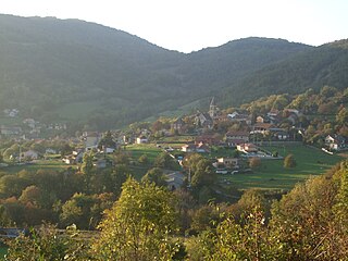
Méjannes-le-Clap is a commune in the Gard department in southern France. It is located 30 km north east of Alès, close to the river Cèze. It is a centre for outdoor activities and environmental tourism.

<span class="mw-page-title-main">Génolhac</span> Commune in Occitania, France

Génolhac is a commune in the Gard department in southern France.

<span class="mw-page-title-main">Steenvoorde</span> Commune in Hauts-de-France, France

Steenvoorde is a commune in the Nord department in northern France. Once part of the Seventeen Provinces of the Low Countries, Steenvoorde was the site of the beginning of the Beeldenstorm, or "Iconoclastic Fury." Today the city is known for its Géants du Nord, sculptures of giants that can be admired in summer festivals.

<span class="mw-page-title-main">Cappelle-en-Pévèle</span> Commune in Hauts-de-France, France

Cappelle-en-Pévèle is a commune in the Nord department in northern France.

<span class="mw-page-title-main">Saint-Étienne-du-Bois, Ain</span> Commune in Auvergne-Rhône-Alpes, France

Saint-Étienne-du-Bois is a commune in the Ain department, eastern France.

<span class="mw-page-title-main">Merdrignac</span> Commune in Brittany, France

Merdrignac is a commune in the Côtes-d'Armor department of Brittany in northwestern France.

<span class="mw-page-title-main">Laragne-Montéglin</span> Commune in Provence-Alpes-Côte dAzur, France

Laragne-Montéglin is a commune in the Hautes-Alpes department in southeastern France.

<span class="mw-page-title-main">Saint-Hilaire-sur-Helpe</span> Commune in Hauts-de-France, France

Saint-Hilaire-sur-Helpe is a commune in the Nord department in northern France.

<span class="mw-page-title-main">Geishouse</span> Commune in Grand Est, France

Geishouse is a commune in the Haut-Rhin department in Grand Est in north-eastern France.

<span class="mw-page-title-main">Bazus-Aure</span> Commune in Occitania, France

Bazus-Aure is a commune in the Hautes-Pyrénées department in southwestern France.

<span class="mw-page-title-main">Murviel-lès-Béziers</span> Commune in Occitania, France

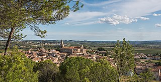
Murviel-lès-Béziers is a commune in the Hérault department in the Occitanie region in southern France.

<span class="mw-page-title-main">Artigues, Hautes-Pyrénées</span> Commune in Occitania, France

Artigues is a commune in the Hautes-Pyrénées department in southwestern France.

<span class="mw-page-title-main">Rocheservière</span> Commune in Pays de la Loire, France

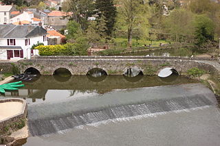
Rocheservière is a commune in the Vendée department in the Pays de la Loire region in western France. The Battle of Rocheservière was fought nearby in 1815.

<span class="mw-page-title-main">Challes-les-Eaux</span> Commune in Auvergne-Rhône-Alpes, France

Challes-les-Eaux, known as Triviers until 1872, is a commune in the Savoie department in the Auvergne-Rhône-Alpes region in Southeastern France. Chambéry Aerodrome is located in the commune.

Les Achards is a commune in the department of Vendée, western France. The municipality was established on 1 January 2017 by merger of the former communes of La Mothe-Achard and La Chapelle-Achard.

References

  1. "Répertoire national des élus: les maires". data.gouv.fr, Plateforme ouverte des données publiques françaises (in French). 2 December 2020.
  2. "Populations légales 2021" (in French). The National Institute of Statistics and Economic Studies. 28 December 2023.
  3. INSEE commune file
  4. "Fiche Climatologique Statistiques 1981-2010 et records" (PDF) (in French). Météo-France . Retrieved 7 September 2022.
  5. Population en historique depuis 1968, INSEE
  6. "Partnerstädte". Sondershausen. Retrieved 4 May 2014.