Related Research Articles

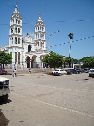
Badiraguato is a small city and seat of the Badiraguato Municipality in the Mexican state of Sinaloa. It stands at 25°21′47″N107°33′06″W. According to 2010 census, the city reported 3,725 inhabitants. The hamlet of La Tuna, located 110 kilometres to the North of the city, is the birthplace of Joaquín "El Chapo" Guzmán, for a long time one of Mexico's most powerful drug lords.

Mocorito is the municipality seat of the Municipality of Mocorito in the Mexican state of Sinaloa.
Navolato is a city in the Mexican state of Sinaloa. It is located in the central coastal part of the state bordering the Gulf of California and serves as the municipal seat for the surrounding municipality of the same name.

Salvador Alvarado Municipality is a municipality in the Mexican state of Sinaloa. It stands at 25°08′09″N107°51′45″W.
Sinaloa de Leyva is a town in the Mexican state of Sinaloa. Its geographical location is 25°36′25″N107°33′18″W. The honorific "de Leyva" commemorates Gabriel Leyva Solano, an early supporter of Francisco I. Madero in the Mexican Revolution who was born there. Sinaloa serves as the municipal seat for the surrounding municipality (municipio) of Sinaloa, Sinaloa. The municipality reported 88,282 inhabitants in the 2010 census. It is a former capital of the state of Sinaloa.

Altata is a small town in Navolato Municipality connected to the Pacific Ocean, located about 45 miles west of Culiacán, Sinaloa in Mexico by Freeway 30.
Pedro Almíndez Chirino was a conquistador born in Úbeda and member of several councils that governed New Spain while Hernán Cortés was traveling to Honduras, in 1525-26. Almíndez was an ally of Gonzalo de Salazar; the events of this period are recounted in that article.

Bešenovo is a village in Serbia. It is located in the Sremska Mitrovica municipality, in the Syrmia District, Vojvodina province. The village has a Serb ethnic majority and the population numbers 965 people. Near the village is Bešenovo monastery, one of 16 Serb Orthodox monasteries on the Fruška Gora mountain.

Perico is a municipality and town in the Matanzas Province of Cuba. It is located south of Marti, north of Colón and east of Jovellanos.

Rincón De Los Montes is a hamlet in the Mexican state of Sinaloa. Its geographical location is 25°15′13″N107°32′36″W.
Dusheti is a municipality of Georgia, in the region of Mtskheta-Mtianeti. It has a population of 25,659 and an area of 2,981.5 km2. Municipality main town is Dusheti.

Atlahuilco is a municipality in the Mexican state of Veracruz. It is located about 131 km from state capital Xalapa. It has a surface of 64.98 km2. It is located at 18°42′N97°05′W.
San Miguel Suchixtepec is a town and municipality in Oaxaca in south-western Mexico. The municipality covers an area of 107.17 km². It is part of the Miahuatlán District in the south of the Sierra Sur Region.
Springfeld is an unincorporated community in Saskatchewan. According to a 2016 Census, Springfeld, also referred to as Springfield, is home to 878 residents.

Municipality of Badiraguato is a municipality in the Mexican state of Sinaloa in northwestern Mexico. The seat of the municipality is in the small town of Badiraguato.
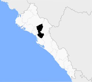
Municipality of Mocorito is a municipality in the Mexican state of Sinaloa in northwestern Mexico. It is bordered to the north by the municipality of Sinaloa, to the south by Navolato, to the southeast by Culiacán, to the east by Badiraguato and to the west with Salvador Alvarado and Angostura. It encompasses a total of 2,800.6 km² and represents 4.9% of the territory of Sinaloa. According to the 2020 census it had a population of 40,358, compromising 270 total localities. Major localities include Pericos, Mocorito, and Caimanero.

Municipality of Navolato is a municipality in the Mexican state of Sinaloa in northwestern Mexico.
Las Flores is located in the municipality of Culiacán in the state of Sinaloa. It has a population of 345 people and it is 92 meters above sea level.

Río Bravo Municipality is one of the municipalities in the Mexican state of Tamaulipas. The seat is at Río Bravo, Tamaulipas.

SS Pennsylvania Sun was a United States tanker that was damaged by U-571, 125 miles (201 km) West of Key West, Florida in the Gulf of Mexico, while traveling from Port Arthur, Texas, to Belfast, United Kingdom. She was repaired and went back in service in 1943, she was eventually scrapped in 1963.
References

25°04′59″N107°42′00″W / 25.083°N 107.700°W
| | This article about a location in the Mexican state of Sinaloa is a stub. You can help Wikipedia by expanding it. |