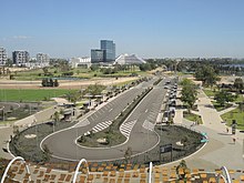
Perth Stadium bus station

Last updated

Perth Stadium Bus Station E37 Perth Stadium Open Day 132 (cropped).JPG
Perth Stadium Bus Station

Perth Stadium bus station is a Transperth bus station, located at the southern edge of Perth Stadium in Burswood, Western Australia. [1] It has 22 stands [2] and is served by eight Transperth special event routes.

Contents

Bus routes

A route 661 bus to Elizabeth Quay at the bus station E37 Perth Stadium Open Day 184.JPG
A route 661 bus to Elizabeth Quay at the bus station

As of 2019, ten bus routes service Perth Stadium Bus Station. [3] These routes connect suburbs without train lines, [4] and only operate before and after events at Perth stadium.

With the opening of the Matagarup Bridge on 14 July 2018, route 661 [lower-alpha 1] was adjusted to service the bus stands near Matagarup Bridge on Nelson Avenue, East Perth. The opening of the bridge also caused the other suburban bus routes to change their bus stands at the bus station. [6]

As of 13 March 2019, the route 655 had introduced to adding in the bus services to Kalamunda via Belmont and Forrestfield. While the route 661 no longer runs in circular and start and terminates at Brookfield Place in Perth CBD, and moved back the terminus from Matagarup Bridge bus stands to Perth Stadium Bus Station to make the room at Nelson Avenue for Taxis and on-demand public transport. Those changes are effective from 24 March 2019. [7]

As of November 2023, The Armadale line shutdown has seen the withdrawal of the 661 with its last service on the last day of the Coldplay concert on 19th November. Instead more Red CATs will run to service the Matagarup Bridge instead. Additionally, a new route 651 will run from Armadale Station to Perth Stadium Bus Station, along with 652 and 653's terminus being shifted to the Matagarup Bridge.

StopRouteDestination / descriptionNotes
[27728] Stands 1, 2 & 3659 Fremantle Station via Canning Highway and Canning Bridge bus station [8] [9]
[27731] Stands 4 & 5658Hamilton Hill via Kardinya Park and Booragoon bus station [9] [10]
[27733] Stands 6 & 7655 Kalamunda Bus Station via Belmont, Forrestfield and High Wycombe Station [9] [11]
[27735] Stands 8 & 9657 Curtin University Bus Station via Curtin Central Bus Station [9] [12]
[27737] Stands 10 & 11656Canning Vale via Bentley Plaza [9] [13]
[27739] Stands 12 & 13654Ellenbrook Town Centre via Bassendean Station and Henley Brook Bus Station [9] [14]
[27741] Stands 14 & 15652 Mirrabooka bus station via Alexander Drive [9] [15]
[27743] Stands 16 & 17653 Morley bus station via Beaufort Street [9] [16]
[27745] Stands 18, 19 & 20650 Karrinyup bus station via Innaloo [9] [17]
[27748] Stands 21 & 22661 Brookfield Place, Perth CBD [9] [18]

Notes

  1. Route 661 previously connected Elizabeth Quay Bus Station to Perth Stadium Bus Station [5]

Related Research Articles

<span class="mw-page-title-main">Armadale line</span> Suburban rail line in Perth, Western Australia

The Armadale line is a suburban railway service in Perth, Western Australia, operated by the Public Transport Authority as part of the Transperth system. The Armadale line is 30.4 kilometres (18.9 mi) long, and starts at Perth station, heading south-east of there to serve Perth's south-eastern suburbs, terminating at Armadale station.

<span class="mw-page-title-main">Perth railway station</span> Railway station in Perth, Western Australia

Perth railway station is the largest station on the Transperth network, serving the central business district of Perth, Western Australia. It serves as an interchange between the Airport, Armadale, Fremantle, Midland, and Thornlie lines as well as Transwa's Australind service. It is also directly connected to Perth Underground railway station, which has the Joondalup line and Mandurah line.

<span class="mw-page-title-main">Armadale railway station, Perth</span> Railway station in Perth, Western Australia

Armadale railway station is located on the South Western Railway, 30 kilometres from Perth station serving the suburb of Armadale, Brookdale and Haynes. It is the terminating point for Transperth Armadale line services and a calling point for Transwa Australind services.

<span class="mw-page-title-main">Challis railway station</span> Railway station in Perth, Western Australia

Challis railway station is a suburban railway station in Kelmscott, a suburb of Perth, Western Australia. It is on the Armadale line which is part of the Transperth network, and is 27.3 kilometres (17.0 mi) southwest of Perth station and 3.1 kilometres (1.9 mi) north of Armadale station. The station opened on 29 October 1973, as did the adjacent Sherwood station, filling the large gap between Armadale station and Kelmscott station. It consists of two side platforms with a pedestrian level crossing. It is not fully accessible due to steep ramps and wide gaps at the pedestrian level crossing.

<span class="mw-page-title-main">Kelmscott railway station</span> Railway station in Perth, Western Australia

Kelmscott railway station is located on the South Western Railway, 25.9 kilometres from Perth Station in the suburb of Kelmscott. It is served by Armadale Line services which are part of the Transperth network.

<span class="mw-page-title-main">Seaforth railway station</span> Railway station in Perth, Western Australia

Seaforth railway station is a suburban railway station in Gosnells, a suburb of Perth, Western Australia. It is on the Armadale line which is part of the Transperth network, and is 22.6 kilometres (14.0 mi) southwest of Perth station and 7.8 kilometres (4.8 mi) north of Armadale station. The station opened on 4 May 1948 with low level platforms. High level platforms were added in 1968. The station consists of two side platforms with a pedestrian level crossing. It is not fully accessible due to steep ramps and a lack of tactile paving.

<span class="mw-page-title-main">Cannington railway station</span> Railway station in Perth, Western Australia

Cannington railway station is located on the Armadale and Thornlie lines, serving the suburb of Cannington south of Perth, Western Australia. It is located 12.2 kilometres (7.6 mi) from Perth Station, and is part of the Transperth commuter rail network. It temporarily closed on 20 November 2023 as part of the Victoria Park-Canning Level Crossing Removal Project.

<span class="mw-page-title-main">Oats Street railway station</span> Railway station in Perth, Western Australia

Oats Street railway station is a temporarily-closed Transperth suburban railway station in Western Australia, located in the Perth suburbs of Carlisle and East Victoria Park. The station was served by the Armadale and Thornlie lines prior to its closure in November 2023.

<span class="mw-page-title-main">Warwick railway station, Perth</span> Railway station in Perth, Western Australia

Warwick railway station is a railway station on the Transperth network. It is located on the Joondalup line, 13 kilometres (8.1 mi) from Perth station serving the suburb of Warwick.

<span class="mw-page-title-main">Burswood, Western Australia</span> Suburb of Perth, Western Australia

Burswood is an inner southeastern suburb of Perth, Western Australia, located immediately across the Swan River from Perth's central business district (CBD). Its local government area is the Town of Victoria Park. Burswood is the location of the State Tennis Centre, Perth Stadium, Belmont Park Racecourse, and the Crown Perth casino and hotel complex.

<span class="mw-page-title-main">Warnbro railway station</span> Railway station in Perth, Western Australia

Warnbro railway station is a commuter railway station in Warnbro, a suburb of Perth, Western Australia. It is on the Mandurah line, which is part of the Transperth commuter rail network, and is located immediately south-east of the interchange of Safety Bay Road and Ennis Avenue. It has two side platforms, linked by a pedestrian overpass accessed by stairs, a lift, and escalators. Services run every 10 minutes during peak, and every 15 minutes between peak. The journey to Perth Underground station is 47.5 kilometres (29.5 mi), and takes 38 minutes. The journey to Mandurah railway station is 23.3 kilometres (14.5 mi), and takes 13 minutes. The station has a bus interchange with seven bus stands and 12 regular bus routes.

<span class="mw-page-title-main">Railways in Perth</span> Public transport system serving Perth, Western Australia

Railways in Perth, the capital city of Western Australia, have existed since 1881, when the Eastern Railway was opened between Fremantle and Guildford. Today, Perth has seven Transperth commuter rail lines and 76 stations.

<span class="mw-page-title-main">Transperth</span> Public transport system serving Perth, Western Australia

Transperth is the public transport system for Perth and surrounding areas in Western Australia. It is managed by the Public Transport Authority (PTA), a state government organisation, and consists of train, bus and ferry services. Bus operations are contracted out to Swan Transit, Path Transit and Transdev. Ferry operations are contracted out to Captain Cook Cruises. Train operations are done by the PTA through their Transperth Train Operations division.

<span class="mw-page-title-main">Perth Stadium</span> Stadium in Perth, Western Australia

Perth Stadium, currently known as Optus Stadium for sponsorship reasons, is a multi-purpose stadium in Perth, Western Australia, located in the suburb of Burswood. It was completed in late 2017 and officially opened on 21 January 2018. The stadium's total capacity is 61,266, including standing room, making it the third-largest stadium in Australia. The stadium can be extended up to 65,000 seats for rectangular sports.

<span class="mw-page-title-main">Perth Stadium railway station</span> Railway station in Perth, Western Australia

Perth Stadium railway station is a railway station in Burswood, Western Australia, next to Perth Stadium. With six platforms, the station is the second largest on the Transperth network, after Perth railway station.

<span class="mw-page-title-main">Matagarup Bridge</span> Pedestrian bridge in Perth, Western Australia

Matagarup Bridge is a suspension pedestrian bridge crossing over the Swan River in Perth, Western Australia. Situated approximately half-way between Heirisson Island and the Goongoongup Bridge, it provides pedestrian access between Burswood and East Perth. The bridge connects visitors to the Burswood Peninsula, including the Perth Stadium, with public transport and car parks in East Perth and the Perth central business district.

<span class="mw-page-title-main">Perth Busport</span> Underground bus station in Perth, Western Australia

Perth Busport is an underground bus station, located underneath Wellington Street, Perth, Western Australia. It was officially opened by then Premier of Western Australia Colin Barnett and then Minister for Transport Dean Nalder on 13 July 2016.

MV <i>Tricia</i> Swan River ferry in Perth, Western Australia

MV Tricia is a ferry owned by the Public Transport Authority and operated under contract by Captain Cook Cruises on Transperth services on the Swan River in Perth, Western Australia. It was named by public vote after the longest-residing member of Perth Zoo, Tricia the Asian elephant.

<span class="mw-page-title-main">Buses in Perth</span> Public transport system serving Perth, Western Australia

Buses in Perth, the capital city of Western Australia, are run under the Transperth brand. The system is owned and managed by the Public Transport Authority and operations are contracted out to private operators: Swan Transit, Path Transit and Transdev.

References

  1. Transperth. "Map of Perth Stadium Bus Station". Government of Western Australia. Archived from the original on 23 January 2018. Retrieved 22 January 2018.
  2. Perpitch, Nicolas (19 January 2018). "How to get to Perth Stadium: Train, bus, car or walk — the best options to get there and home". ABC News. Australian Broadcasting Corporation. Archived from the original on 22 January 2018. Retrieved 22 January 2018.Additional archives: 22 January 2018 .
  3. Transperth. "Optus Stadium". Government of Western Australia. Archived from the original on 22 January 2018. Retrieved 13 March 2019.Additional archives: 22 January 2018 .
  4. Johns, David (22 January 2018). "How to get to Optus Stadium in Perth using public transport: bus and train times". Southern Gazette. Community News Group. Archived from the original on 23 January 2018. Retrieved 23 January 2018.Additional archives: 23 January 2018 .
  5. Transperth. "Route 661". Government of Western Australia. Retrieved 22 January 2018.
  6. "Transperth Optus Stadium". Transperth. 14 July 2018.
  7. Optus Stadium transport options expand for start of AFL season Archived 16 April 2019 at the Wayback Machine , Rita Saffioti, Government of Western Australia Media Statements, 13 March 2019, accessed 13 March 2019.
  8. Transperth. "Route 659" (PDF). Government of Western Australia. Retrieved 13 March 2019.
  9. 1 2 3 4 5 6 7 8 9 10 Transperth. "Perth Stadium Bus Station Stand Allocations" (PDF). Government of Western Australia. Archived (PDF) from the original on 8 June 2022. Retrieved 13 March 2019.
  10. Transperth. "Route 658" (PDF). Government of Western Australia. Retrieved 13 March 2019.
  11. Transperth. "Route 655" (PDF). Government of Western Australia. Retrieved 13 March 2019.
  12. Transperth. "Route 657" (PDF). Government of Western Australia. Retrieved 13 March 2019.
  13. Transperth. "Route 656" (PDF). Government of Western Australia. Retrieved 13 March 2019.
  14. Transperth. "Route 654" (PDF). Government of Western Australia. Retrieved 13 March 2019.
  15. Transperth. "Route 652" (PDF). Government of Western Australia. Retrieved 13 March 2019.
  16. Transperth. "Route 653" (PDF). Government of Western Australia. Retrieved 13 March 2019.
  17. Transperth. "Route 650" (PDF). Government of Western Australia. Retrieved 13 March 2019.
  18. Transperth. "Route 661" (PDF). Government of Western Australia. Retrieved 13 March 2019.

31°57′14″S115°53′24″E / 31.954°S 115.890°E / -31.954; 115.890