An abbey is a type of monastery used by members of a religious order under the governance of an abbot or abbess. Abbeys provide a complex of buildings and land for religious activities, work, and housing of Christian monks and nuns.

The Abbey of Saint Gall is a dissolved abbey (747–1805) in a Catholic religious complex in the city of St. Gallen in Switzerland. The Carolingian-era monastery existed from 719, founded by Saint Othmar on the spot where Saint Gall had erected his hermitage. It became an independent principality between 9th and 13th centuries, and was for many centuries one of the chief Benedictine abbeys in Europe. The library of the Abbey is one of the oldest monastic libraries in the world.

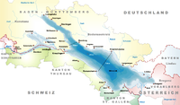
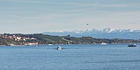
Lake Constance refers to three bodies of water on the Rhine at the northern foot of the Alps: Upper Lake Constance (Obersee), Lower Lake Constance (Untersee), and a connecting stretch of the Rhine, called the Lake Rhine (Seerhein). These waterbodies lie within the Lake Constance Basin in the Alpine Foreland through which the Rhine flows. The nearby Mindelsee is not considered part of Lake Constance.

Morden is a district and town in south London, England, within the London Borough of Merton, in the ceremonial county of Greater London. It adjoins Merton Park and Wimbledon to the north, Mitcham to the east, Sutton to the south and Worcester Park to the west, and is around 8 miles (13 km) south-southwest of Charing Cross. Prior to the creation of Greater London in 1965, for local government purposes, Morden was in the administrative and historic county of Surrey.

Reichenau is a village in the municipality of Tamins in the Canton of Graubünden, Switzerland, where the two Rhine tributaries Vorderrhein and Hinterrhein meet, forming the Alpine Rhine.

Ramsey is a market town and civil parish in the Huntingdonshire district of Cambridgeshire, England. The town is about 9 miles (14 km) north of Huntingdon. Ramsey parish includes the settlements of Ramsey Forty Foot, Ramsey Heights, Ramsey Mereside, Ramsey Hollow and Ramsey St Mary's.

Homebush is a suburb in the Inner West of Sydney in the state of New South Wales, Australia. It is located 12 kilometres west of the Sydney central business district, in the local government area of the Municipality of Strathfield.

Reichenau Island is an island in Lake Constance in Southern Germany. It lies almost due west of the city of Konstanz, between the Gnadensee and the Untersee, two parts of Lake Constance. With a total land surface of 4.3 km2 (1.7 sq mi) and a circumference of 11 km (6.8 mi), the island is 4.5 km (2.8 mi) long and 1.5 km (0.93 mi) wide at its greatest extent. The highest point, the Hochwart, stands some 43 m (141 ft) above the lake surface and 438.7 m (1,439 ft) above mean sea level.
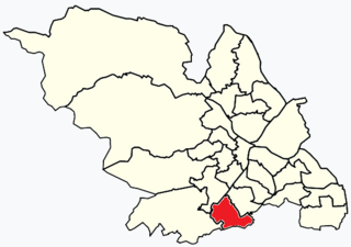
Beauchief and Greenhill ward—which includes the districts of Batemoor, Beauchief, Chancet Wood, Greenhill, Jordanthorpe, Lowedges and Meadowhead—is one of the 28 electoral wards in the City of Sheffield, England. It is in the southern part of the city and covers an area of 2.4 square miles (6.2 km2). The population of the ward in 2016 was estimated to be 19,669 people in 9,209 houses.
Liss is a village and civil parish in the East Hampshire district of Hampshire, 3.3 miles (5.3 km) north-east of Petersfield, on the A3 road, on the West Sussex border. It covers 3,567 acres (14 km2) of semi-rural countryside in the South Downs National Park. Liss railway station is on the Portsmouth Direct line. The village comprises an old village at West Liss and a modern village round the 19th-century station. They are divided by the River Rother. Suburbs later spread towards Liss Forest.

Ottonian art is a style in pre-romanesque German art, covering also some works from the Low Countries, northern Italy and eastern France. It was named by the art historian Hubert Janitschek after the Ottonian dynasty which ruled Germany and Northern Italy between 919 and 1024 under the kings Henry I, Otto I, Otto II, Otto III and Henry II. With Ottonian architecture, it is a key component of the Ottonian Renaissance. However, the style neither began nor ended to neatly coincide with the rule of the dynasty. It emerged some decades into their rule and persisted past the Ottonian emperors into the reigns of the early Salian dynasty, which lacks an artistic "style label" of its own. In the traditional scheme of art history, Ottonian art follows Carolingian art and precedes Romanesque art, though the transitions at both ends of the period are gradual rather than sudden. Like the former and unlike the latter, it was very largely a style restricted to a few of the small cities of the period, and important monasteries, as well as the court circles of the emperor and his leading vassals.
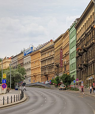
The New Town is a quarter in the city of Prague in the Czech Republic. New Town is the youngest and largest of the five independent towns that today comprise the historic center of modern Prague. New Town was founded in 1348 by Charles IV just outside the city walls to the east and south of the Old Town and encompassed an area of 7.5 km²; about three times the size of the Old Town. The population of Prague in 1378 was well over 40,000, perhaps as much as twice that, making it the 4th most populated city north of the Alps and, by area, the 3rd largest city in Europe. Although New Town can trace its current layout to its construction in the 14th century, only few churches and administrative buildings from this time survive. There are many secular and educational buildings in New Town, but also especially magnificent gothic and baroque churches. These nevertheless are not the main drawing points for tourists. New Town's most famous landmark is Wenceslas Square, which was originally built as a horsemarket and now functions as a center of commerce and tourism. In the 15th century, the Novoměstská radnice, or New Town Hall, was the site of the first of the three defenestrations of Prague.

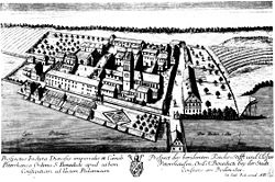
Petershausen Abbey was a Benedictine imperial abbey at Petershausen, now a district of Konstanz in Baden-Württemberg, Germany.

Darley Abbey is a former historic mill village, now a suburb of the city of Derby, in the ceremonial county of Derbyshire, England. It is located approximately 1.4 miles (2.3 km) north of the city centre, on the west bank of the River Derwent, and forms part of the Darley ward along with Little Chester and the West End. The settlement dates back to the medieval era, when it was the site of an Augustinian monastery. In the 18th century, the Evans family developed their planned industrial mill village in the area; Darley Abbey is now part of the Derwent Valley Mills World Heritage Site.

Reichenau an der Rax is a market town in the Austrian state of Lower Austria, situated at the foot of the Rax mountain range on the Schwarza river, a headstream of the Leitha.

Uhldingen-Mühlhofen is a town at the northern shore of Lake Constance, Germany between Überlingen and Meersburg. The town is a popular holiday destination and home to the Pfahlbauten open-air museum in Unteruhldingen and the Birnau basilica.

Ermatingen is a municipality in the district of Kreuzlingen in the canton of Thurgau in Switzerland.

The Seerhein is a river about 4.3 km (2.7 mi) long, in the basin of Lake Constance. It is the outflow of the Upper Lake Constance and the main tributary of the Lower Lake Constance. The water level of the Lower Lake is about 30 cm (12 in) below the level of the Upper Lake. It is considered part of the River Rhine, which flows into Lake Constance as the Alpine Rhine and flows out of the Lower Lake as the High Rhine.

The Dominican Island or Constance Island is an island in Lake Constance immediately east of the city of Constance. With an area of 1.8 hectares, it is one of the smaller islands in the lake. The island is separated from the city center by a six-metre-wide (20 ft) channel, and connected to it by a bridge. The island is dominated by the Steigenberger hotel, which is housed in the former Dominican convent.

The Saint James Scots Monastery in Constance, Germany was a Benedictine monastery, which, like the other Scots monasteries, was founded by Irish monks in the course of the second phase of the Hiberno-Scottish mission. It was situated to the west of the historic city wall near the banks of the Rhine on what is known today as Schottenstraße.
