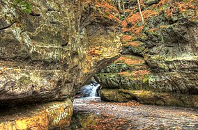
Westboro is a town in Taylor County, Wisconsin, United States. The population was 660 at the 2000 census. The census-designated place of Westboro is located in the town. The unincorporated community of Queenstown is also located in the town.

Cedar Breaks National Monument is a U.S. National Monument located in the U.S. state of Utah near Cedar City. Cedar Breaks is a natural amphitheater, stretching across 3 miles (4.8 km), with a depth of over 2,000 feet (610 m). The elevation of the rim of the amphitheater is over 10,000 feet (3,000 m) above sea level. Rising above the rim is the prominent Brian Head, the peak of which lies a short distance outside of the National Monument boundary.

The Dells of the Wisconsin River, also called the Wisconsin Dells, meaning “valley”, is a 5-mile (8-km) gorge on the Wisconsin River in south-central Wisconsin, USA. It is noted for its scenic beauty, in particular for its unique Cambrian sandstone rock formations and tributary canyons. The formations are divided into the "Upper Dells" and the "Lower Dells" by the Kilbourn Dam.
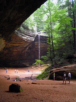
Hocking Hills State Park is a state park in the Hocking Hills region of Hocking County, Ohio, United States. In some areas the park adjoins the Hocking State Forest. Within the park are over 25 miles (40 km) of hiking trails, rock formations, waterfalls, and recess caves. The trails are open from dawn to dusk, all year round, including holidays.
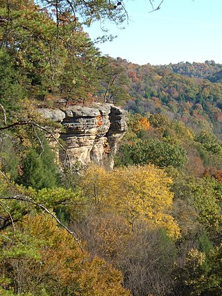
The Hocking Hills is a deeply dissected area of the Allegheny Plateau in Appalachian Ohio, primarily in Hocking County, that features cliffs, gorges, rock shelters, and waterfalls. The relatively extreme topography in this area is due to the Blackhand Sandstone, a particular formation that is thick, hard and weather-resistant, and so forms high cliffs and narrow, deep gorges.

The Driftless Area, a topographical and cultural region in the American Midwest, comprises southwestern Wisconsin, southeastern Minnesota, northeastern Iowa, and the extreme northwestern corner of Illinois.

Banning State Park is a state park of Minnesota, USA, stretched along 10 miles (16 km) of the Kettle River near Sandstone in Pine County. The centerpiece of the park is 1.5 miles (2.4 km) of churning rapids, some up to Class IV. The daring kayakers and canoeists who shoot Blueberry Slide, Mother's Delight, Dragon's Tooth, Little Banning, and Hell's Gate each spring attract spectators to the park. Landbound visitors can hike along the state's first Wild and Scenic River amid dramatic sandstone rock formations, large potholes carved by the river, and the remains of an historic quarry. Other features are Wolf Creek Falls and Robinson Ice Cave. The park is located directly off Interstate 35. Banning State Park is open daily from 8am until 10pm. Each vehicle entering the park requires an up to date permit which can be purchased online or at the park office.
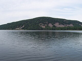
Devil's Lake is a lake in the South Range of the Baraboo Range, about two miles south of Baraboo, Wisconsin, in Sauk County, Wisconsin, United States. It has no surface outlets, so by some definitions, it is endorheic; however, it possibly drains by underground channels into the Baraboo River, which would make the lake cryptorheic. The lake is one of the primary attractions of Devil's Lake State Park. It is also a popular recreation destination for watercraft, fishing, hiking, and climbing.

Carnarvon Gorge is located in the Southern Brigalow Belt bioregion in Central Queensland (Australia), 593 km northwest of Brisbane. Primarily created by water erosion, Carnarvon Gorge is around 30 kilometres long, located in Carnarvon National Park, and six hundred metres deep at the mouth. It is the most visited feature within Carnarvon National Park due to the diversity of experiences it contains and the ease with which it can be accessed. The closest towns are Injune and Rolleston.

Little Pine State Park is a Pennsylvania state park on 2,158 acres (873 ha) in Cummings Township, Lycoming County, Pennsylvania in the United States. Little Pine State park is along 4.2 miles (6.8 km) of Little Pine Creek, a tributary of Pine Creek, in the midst of the Tiadaghton State Forest. A dam on the creek has created a lake covering 94 acres (38 ha) for fishing, boating, and swimming. The park is on Pennsylvania Route 4001, 4 miles (6.4 km) northeast of the unincorporated village of Waterville or 8 miles (13 km) southwest of the village of English Center. The nearest borough is Jersey Shore, Pennsylvania, about 15 miles (24 km) south at the mouth of Pine Creek on the West Branch Susquehanna River.
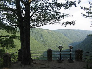
Colton Point State Park is a 368-acre (149 ha) Pennsylvania state park in Tioga County, Pennsylvania, in the United States. It is on the west side of the Pine Creek Gorge, also known as the Grand Canyon of Pennsylvania, which is 800 feet (240 m) deep and nearly 4,000 feet (1,200 m) across at this location. The park extends from the creek in the bottom of the gorge up to the rim and across part of the plateau to the west. Colton Point State Park is known for its views of the Pine Creek Gorge, and offers opportunities for picnicking, hiking, fishing and hunting, whitewater boating, and camping. Colton Point is surrounded by Tioga State Forest and its sister park, Leonard Harrison State Park, on the east rim. The park is on a state forest road in Shippen Township 5 miles (8 km) south of U.S. Route 6.
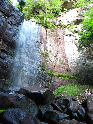
Bad Branch Falls State Nature Preserve is a forested gorge covering 2,639 acres near Whitesburg, KY in Letcher County, Kentucky. The deep and narrow gorge, adjacent to the Jefferson National Forest is carved into the face of Pine Mountain. Sandstone boulders and cliffs along with riglines and knobs provide views into the Appalachia area. The terrain is landscaped with streams, rivers, and a 60-foot waterfall. With a variety of habitat types, this nature preserve is home to many unique and unknown species of flora and fauna.

The Appalachian–Blue Ridge forests are an ecoregion in the Temperate broadleaf and mixed forests Biome, in the Eastern United States. The ecoregion is located in the central and southern Appalachian Mountains, including the Ridge-and-Valley Appalachians and the Blue Ridge Mountains. It covers an area of about 61,500 square miles (159,000 km2) in: northeast Alabama and Georgia, northwest South Carolina, eastern Tennessee, western North Carolina, Virginia, Maryland, and central West Virginia and Pennsylvania; and small extensions into Kentucky, New Jersey, and New York.

Mirror Lake State Park is a 2,179-acre (882 ha) Wisconsin state park in the Wisconsin Dells region. The process of establishing the park began in 1962 and the park officially opened on August 19, 1966. It contains Mirror Lake, a narrow reservoir with steep sandstone sides up to 50 feet (15 m) tall. The lake has a surface area of 137 acres (55 ha) and an average depth of 10 to 14 feet. Recessed out of the wind, the water of Mirror Lake is usually calm and often as glassy-smooth as a mirror, hence the name. Situated in a major tourist area, the state park has an extensive campground and other visitor amenities. Also located within the park is the Seth Peterson Cottage, a Frank Lloyd Wright-designed building available for public rental.

The Baraboo Range is a syncline located in Columbia and Sauk Counties, Wisconsin. It consists of highly eroded Precambrian metamorphic rock. It is about 25 miles (40 km) long and varies from 5 to 10 miles (16 km) in width. The Wisconsin River, previously traveling in a north to south direction, turns to the east just north of the range before making its turn to the west towards the Upper Mississippi River. The eastern end of the range was glaciated during the Wisconsinian glaciation, while the western half was not, and consequently, marks the eastern boundary of Wisconsin's Driftless Area.

Rocky Arbor State Park is a 244-acre (99 ha) Wisconsin state park in the Wisconsin Dells region. The park was established in 1932 to protect sandstone outcrops eroded into picturesque walls and ledges.

The Canyons of the Escalante is a collective name for the erosional landforms created by the Escalante River and its tributaries—the Escalante River Basin. Located in southern Utah in the western United States, these sandstone features include high vertical canyon walls, numerous slot canyons, waterpockets, domes, hoodoos, natural arches and bridges. This area—extending over 1,500 square miles (3,885 km2) and rising in elevation from 3,600 ft (1,097 m) to over 11,000 ft (3,353 m)—is one of the three main sections of the Grand Staircase–Escalante National Monument, and also a part of the Glen Canyon National Recreation Area, with Capitol Reef National Park being adjacent to the east.

Spearfish Canyon is a deep but narrow gorge carved by Spearfish Creek located in Lawrence County, South Dakota, U.S., just south of Spearfish. The canyon is located within the Black Hills, located on the northern edge of the Black Hills National Forest. The Spearfish Canyon Scenic Byway travels through the Canyon from Spearfish to Cheyenne Crossing along U.S. Route 14A. The highway follows an old railroad grade that was abandoned after massive flooding in 1933.

Parfrey's Glen, located within Devil's Lake State Park, is a Wisconsin Department of Natural Resources-designated State Natural Area. The glen is a deep gorge cut through the sandstone of the south flank of the Baraboo Hills. It was the first State Natural Area to be designated in Wisconsin. The valley was named for Robert Parfrey.
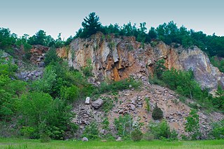
Ableman's Gorge is a 127 acres (51 ha) Wisconsin State Natural Area located near Rock Springs, Wisconsin. This 200 to 400-foot wide and 200-foot high gorge is cut by about 1 mile (1.6 km) of the Baraboo River in an "L" shape. The Natural Area is named after George Ableman, who settled Rock Springs in 1851 and named the community after the gorge area.
