Phillips, Oklahoma

Last updated

Phillips, Oklahoma
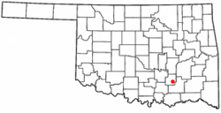
OKMap-doton-Phillips.PNG
Location of Phillips, Oklahoma
Coordinates: 34°30′15″N96°13′23″W / 34.50417°N 96.22306°W / 34.50417; -96.22306
Country United States
State Oklahoma
County Coal
Area
[1]
  Total0.53 sq mi (1.37 km2)
  Land0.53 sq mi (1.36 km2)
  Water0.00 sq mi (0.01 km2)
Elevation
[2]
594 ft (181 m)
Population
 (2020)
  Total122
  Density232.38/sq mi (89.75/km2)
Time zone UTC-6 (Central (CST))
  Summer (DST) UTC-5 (CDT)
ZIP code
74538
Area code 580
FIPS code 40-58500 [3]
GNIS feature ID2413128 [2]

Phillips is a town in Coal County, Oklahoma, United States. The population was 135 at the 2010 census. [4]

Contents

History

A post office was established at Phillips, Indian Territory on April 2, 1892. It closed on April 2, 1927. It was named for Henry L. Phillips, a coal mine operator. [5]

At the time of its founding, Phillips was located in Atoka County, a part of the Pushmataha District of the Choctaw Nation. [6]

Geography

Phillips is located in southeastern Coal County. U.S. Route 75 passes through the town, leading north 2.5 miles (4.0 km) to Coalgate, the county seat, and south 2.5 miles (4.0 km) to Lehigh.

According to the United States Census Bureau, the town has a total area of 0.50 square miles (1.3 km2), all land. [4]

Demographics

Historical population
CensusPop.Note
1910 680
1920 97242.9%
1930 176−81.9%
1940 21220.5%
1950 181−14.6%
1960 91−49.7%
1970 10616.5%
1980 17867.9%
1990 161−9.6%
2000 150−6.8%
2010 135−10.0%
2020 122−9.6%
U.S. Decennial Census [7]

As of the census [3] of 2000, there were 150 people, 58 households, and 41 families residing in the town. The population density was 286.1 inhabitants per square mile (110.5/km2). There were 64 housing units at an average density of 122.1 per square mile (47.1/km2). The racial makeup of the town was 65.33% White, 20.00% Native American, and 14.67% from two or more races. Hispanic or Latino of any race were 0.67% of the population.

There were 58 households, out of which 34.5% had children under the age of 18 living with them, 50.0% were married couples living together, 17.2% had a female householder with no husband present, and 27.6% were non-families. 24.1% of all households were made up of individuals, and 10.3% had someone living alone who was 65 years of age or older. The average household size was 2.59 and the average family size was 3.05.

In the town, the population was spread out, with 28.0% under the age of 18, 8.7% from 18 to 24, 30.7% from 25 to 44, 22.7% from 45 to 64, and 10.0% who were 65 years of age or older. The median age was 34 years. For every 100 females, there were 111.3 males. For every 100 females age 18 and over, there were 100.0 males.

The median income for a household in the town was $33,750, and the median income for a family was $36,667. Males had a median income of $47,500 versus $23,750 for females. The per capita income for the town was $13,439. There were 27.1% of families and 21.9% of the population living below the poverty line, including 15.6% of under eighteens and 12.5% of those over 64.

Related Research Articles

<span class="mw-page-title-main">Essex, Illinois</span> Village in Illinois, United States

Essex is a village in Kankakee County, Illinois, United States. The population was 802 at the 2010 census, up from 554 at the 2000 census. It is included in the Kankakee-Bradley, Illinois Metropolitan Statistical Area.

<span class="mw-page-title-main">Centrahoma, Oklahoma</span> City in Oklahoma, United States

Centrahoma is a rural small town in Coal County, Oklahoma, United States. The population was 97 at the 2010 census.

<span class="mw-page-title-main">Bradley, Oklahoma</span> Town in Oklahoma, United States

Bradley is a town in Grady County, Oklahoma, United States. The population was 78 at the 2020 United States census.

<span class="mw-page-title-main">Ninnekah, Oklahoma</span> Town in Oklahoma, United States

Ninnekah is a town in Grady County, Oklahoma, United States. The population was 775 at the 2020 census, a 22.7% decrease from 2010.

<span class="mw-page-title-main">Norge, Oklahoma</span> Town in Oklahoma, United States

Norge is a town in Grady County, Oklahoma, United States. The population was 129 at the 2020 census, a 11% decrease from 2010.

<span class="mw-page-title-main">Howe, Oklahoma</span> Town in Oklahoma, United States

Howe is a town in Le Flore County, Oklahoma, United States. It is part of the Fort Smith, Arkansas-Oklahoma Metropolitan Statistical Area. The population was 802 at the 2010 census, a gain of 15.1 percent over the figure of 697 recorded in 2000. The town was once noted for producing coal and coke, but today is chiefly supported by agriculture.

<span class="mw-page-title-main">Panama, Oklahoma</span> Town in Oklahoma, United States

Panama is a town in Le Flore County, Oklahoma, United States. It is part of the Fort Smith, Arkansas-Oklahoma Metropolitan Statistical Area. The population was 1,413 at the 2010 census.

<span class="mw-page-title-main">Shady Point, Oklahoma</span> Town in Oklahoma, United States

Shady Point, sometimes referred to as Shadypoint, is a town in Le Flore County, Oklahoma, United States. It is part of the Fort Smith, Arkansas-Oklahoma Metropolitan Statistical Area. The population was 1,026 at the 2010 census, a 21.0 percent increase over the figure of 848 recorded in 2000.

<span class="mw-page-title-main">Kendrick, Oklahoma</span> Town in Oklahoma, United States

Kendrick is a town in Lincoln County, Oklahoma, United States. The population was 139 at the 2010 census.

<span class="mw-page-title-main">Lake Aluma, Oklahoma</span> Town in Oklahoma, United States

Lake Aluma is a town in Oklahoma County, Oklahoma, United States, and a part of the Oklahoma City Metropolitan Area. The population was 88 at the 2010 census.

<span class="mw-page-title-main">Dewar, Oklahoma</span> Town in Oklahoma, United States

Dewar is a town in Okmulgee County, Oklahoma, United States. The population was 763 at the 2020 census. Founded in 1909 by workers for the Missouri, Oklahoma and Gulf Railway (MO&G), it was named for William Peter Dewar, a railroad official. It incorporated in 1909.

<span class="mw-page-title-main">Schulter, Oklahoma</span> Town in Oklahoma, United States

Schulter is a town in Okmulgee County, Oklahoma, United States. The population was 422 at the time of the 2020 census.

Pittsburg is a town in Pittsburg County, Oklahoma, United States. The population was 280 at the 2000 census.

<span class="mw-page-title-main">Savanna, Oklahoma</span> Town in Oklahoma, United States

Savanna is a town in Pittsburg County, Oklahoma, United States. The population was 686 at the 2010 census, a decline of 6.0 percent from the figure of 730 recorded in 2000. It is the hometown of former Harlem Globetrotter and 2014 NAIA Dunk Champion Tyler Inman.

<span class="mw-page-title-main">Tribbey, Oklahoma</span> Town in Oklahoma, United States

Tribbey is a town in Pottawatomie County, Oklahoma, United States.The community was named for Alpheus M. Tribbey, landowner. The population was 337 by the 2020 United States census.

<span class="mw-page-title-main">Sylvester, West Virginia</span> Town in West Virginia, United States

Sylvester is a town in Boone County, West Virginia, United States, along the Big Coal River. The population was 166 at the 2020 census. Sylvester was incorporated on April 11, 1952, by the Boone County Circuit Court. Sylvester bears the name of a family of settlers.

<span class="mw-page-title-main">Whitesville, West Virginia</span> Town in West Virginia, United States

Whitesville is a town and former coal town in Boone County, West Virginia, United States, along the Big Coal River. The population was 361 at the 2020 census. Whitesville was incorporated on August 15, 1935, by the Boone County Circuit Court. The town derives its name from B. W. White, a pioneer settler. Whitesville was formerly known as Jarrold's Valley and Pritchard City.

<span class="mw-page-title-main">Bramwell, West Virginia</span> Town in West Virginia, United States

Bramwell is a town in Mercer County, West Virginia, United States, along the Bluestone River. The population was 277 at the 2020 census. It is part of the Bluefield, WV-VA micropolitan area which has a population of 107,578.

<span class="mw-page-title-main">Bancroft, West Virginia</span> Town in West Virginia, United States

Bancroft is a town in Putnam County, West Virginia, United States, along the Kanawha River. The population was 389 at the 2020 census. It is part of the Huntington–Ashland metropolitan area.

<span class="mw-page-title-main">Fair Oaks, Oklahoma</span> Town in Oklahoma, United States

Fair Oaks is a town in Rogers and Wagoner counties in the U.S. state of Oklahoma. The population was 103 at the 2010 census, a 15.6 percent decline from the figure of 122 recorded in 2000. It is a suburb of Tulsa.

References

  1. "ArcGIS REST Services Directory". United States Census Bureau. Retrieved September 20, 2022.
  2. 1 2 U.S. Geological Survey Geographic Names Information System: Phillips, Oklahoma
  3. 1 2 "U.S. Census website". United States Census Bureau . Retrieved January 31, 2008.
  4. 1 2 "Geographic Identifiers: 2010 Demographic Profile Data (G001): Phillips town, Oklahoma". U.S. Census Bureau, American Factfinder. Archived from the original on March 9, 2015. Retrieved March 4, 2015.
  5. Shirk, George H. Oklahoma Place Names (Norman: University of Oklahoma, 1965), p. 166.
  6. Morris, John W. Historical Atlas of Oklahoma (Norman: University of Oklahoma, 1986), plate 38.
  7. "Census of Population and Housing". Census.gov. Retrieved June 4, 2015.