An impact crater is a depression in the surface of a solid astronomical body formed by the hypervelocity impact of a smaller object. In contrast to volcanic craters, which result from explosion or internal collapse, impact craters typically have raised rims and floors that are lower in elevation than the surrounding terrain. Impact craters are typically circular, though they can be elliptical in shape or even irregular due to events such as landslides. Impact craters range in size from microscopic craters seen on lunar rocks returned by the Apollo Program to simple bowl-shaped depressions and vast, complex, multi-ringed impact basins. Meteor Crater is a well-known example of a small impact crater on Earth.

The Bungle Bungle Range is a major landform and the main feature of the Purnululu National Park, situated in the Kimberley region of Western Australia.

Acraman impact structure is a deeply eroded impact crater in the Gawler Ranges of South Australia. Its location is marked by Lake Acraman, a circular ephemeral playa lake about 20 kilometres (12 mi) in diameter. The discovery of the impact structure and independent discovery of its ejecta were first reported in the journal Science in 1986 by George E. Williams. The evidence for impact includes the presence of shatter cones and shocked quartz in shattered bedrock on islands within Lake Acraman.
Connolly Basin is a 9 km-diameter impact crater located in the Gibson Desert of central Western Australia. It lies adjacent to the Talawana Track 45 km west of the junction with the Gary Highway, but is difficult to access due to the remoteness of the area. It was originally thought to be a diapir ; an impact origin was first proposed in 1985.,

Dalgaranga crater is a small meteorite impact crater located on Dalgaranga pastoral station 75 km (47 mi) northwest of Mount Magnet in Western Australia. It is only 24 m (79 ft) in diameter and 3 m (9.8 ft) deep, making it Australia's smallest impact crater. Though discovered in 1921, it was not reported in the scientific literature until 1938. The bedrock at the site is weathered Archaean granite of the Yilgarn Craton. The discovery of fragments of mesosiderite stony-iron meteorite around the crater confirms an impact origin, making this crater unique as the only one known to have been produced by a mesosiderite projectile.

Gosses Bluff is thought to be the eroded remnant of an impact crater. Known as Tnorala to the Western Arrernte people of the surrounding region, it is located in the southern Northern Territory, near the centre of Australia, about 175 km (109 mi) west of Alice Springs and about 212 km (132 mi) to the northeast of Uluru. It was named by Ernest Giles in 1872 after Australian explorer William Gosse's brother Henry, who was a member of William's expedition.
Kelly West is a deeply eroded impact crater situated in the central Northern Territory, Australia. It was discovered during Government geological mapping and first reported in 1973, the evidence for impact coming principally from an abundance of shatter cones at the site.

Lawn Hill ‘crater’ refers to an Ordovician impact structure, the eroded remnant of a former impact crater, situated approximately 220 km north-north-west of Mount Isa in northwestern Queensland, Australia. The site is marked by an 18 km diameter ring of dolomite hills. The origin of this circular feature was uncertain until the discovery of shatter cones and shocked quartz from uplifted rocks at the centre was reported in 1987.

Liverpool is a meteorite impact crater situated in Arnhem Land within the Northern Territory, Australia. It was named after the nearby Liverpool River. Liverpool is remote and difficult to access. The crater has a raised, near-circular rim averaging about 1.6 km in diameter. It was first noticed by geologists during reconnaissance geological mapping in the 1960s, and although an impact origin was considered possible, this was not confirmed until a more detailed study was undertaken in 1970.

Mount Toondina crater is an impact structure, the eroded remnant of a former impact crater, located in northern South Australia in the locality of Allandale Station about 24 km (15 mi) south of the town of Oodnadatta. Mount Toondina is the high point of a circular topographic feature rising out of an otherwise relatively flat desert area of the Eromanga Basin. An impact origin was first suggested in 1976, challenging the earlier diapir hypothesis, and strongly supported by subsequent studies. A geophysical survey using gravity methods indicates an internal structure typical of complex impact craters, including an uplifted centre, and suggests that the original crater was about 3–4 km in diameter. The crater must be younger than the Early Cretaceous age of the rocks in which it is situated, but otherwise is not well dated. It has clearly undergone significant erosion since the impact event.

Shoemaker is an impact structure, the deeply eroded remnant of a former impact crater, situated in arid central Western Australia, about 100 km (62 mi) north-northeast of Wiluna. It is named in honour of planetary geologist Eugene Shoemaker.
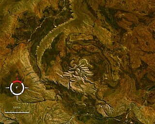
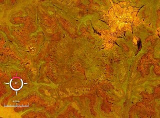
Spider is an impact structure, the deeply eroded remnant of a former impact crater, situated in the Kimberley region of northern Western Australia, 18 km east of the Mount Barnett Roadhouse on the Gibb River Road. Due to very rugged terrain the site is effectively inaccessible. The name is derived from the visually striking spider-like radiating ridges of quartzite prominently visible from the air or on satellite images.

Strangways is a large impact structure, the eroded remnant of a former impact crater, located in the Northern Territory of Australia about 65 kilometres (40 mi) east-south-east of the town of Mataranka. It was named after the nearby Strangways River. The location is remote and difficult to access. Its age has been determined as approximately 646 Ma.

Veevers crater is an impact crater located on a flat desert plain between the Great Sandy and Gibson Deserts in the centre of the state of Western Australia.

The Vredefort impact structure is the largest verified impact structure on Earth. The crater, which has since been eroded away, has been estimated at 170–300 kilometres (110–190 mi) across when it was formed. The remaining structure, comprising the deformed underlying bedrock, is located in present-day Free State province of South Africa. It is named after the town of Vredefort, which is near its centre. The structure's central uplift is known as the Vredefort Dome. The impact structure was formed during the Paleoproterozoic Era, 2.023 billion years ago. It is the second-oldest known impact structure on Earth, after Yarrabubba.

Kebira Crater is the name given to a circular topographic feature that was identified in 2007 by Farouk El-Baz and Eman Ghoneim using satellite imagery, Radarsat-1, and Shuttle Radar Topography Mission (SRTM) data in the Sahara desert. This feature straddles the border between Egypt and Libya. The name of this feature is derived from the Arabic word for "large", and also from its location near the Gilf Kebir region in southwest Egypt. Based solely on their interpretations of the remote sensing data, they argue that this feature is an exceptionally large, double-ringed, extraterrestrial impact crater. They suggest that the crater's original appearance has been obscured by wind and water erosion over time. Finally, they speculated that this feature might be the source of the yellow-green silica glass fragments, known as "Libyan desert glass", that can be found across part of Egypt's Libyan Desert. They neither conducted any fieldwork at this feature nor studied any samples collected from it. However, the Kebira Crater is currently not listed in the Earth Impact Database. Field trips to investigate the feature have found no supporting evidence. The "central uplift" clearly retains the horizontal bedding of the surrounding sandstone tableland, providing clear evidence against a possible impact origin.

Cleopatra is an impact crater on Venus, in Maxwell Montes. Cleopatra is a double-ring impact basin about 100 kilometers (62 mi) in diameter and 2.5 kilometers (1.6 mi) deep. A steep-walled, winding channel a few kilometers wide breaks through the rough terrain surrounding the crater rim. A large amount of lava originating in Cleopatra flowed through this channel and filled valleys in Fortuna Tessera. Cleopatra is superimposed on the structures of Maxwell Montes and appears to be undeformed, indicating that Cleopatra is relatively young. The crater is named after Egyptian queen Cleopatra VII.

Glikson crater is an impact structure, the eroded remnant of a former impact crater, situated in the Little Sandy Desert of central Western Australia. A possible impact structure was first reported in 1997, and named after Australian geologist A. Y. Glikson, attention to the site being drawn by the presence of a prominent 14 km diameter ring-shaped aeromagnetic anomaly. The area within the ring contains sparse outcrop of uplifted and deformed Neoproterozoic sandstone, but is largely covered by sand dunes. The recent discovery of shatter cones and microscopic shock effects is reliable evidence for an impact origin. Deformation of the sandstone consistent with an impact origin extends out to a diameter of 19 km, which is the best estimate for the original diameter of the original crater. The ring-shaped aeromagnetic anomaly was probably caused by disruption of a horizontal layer of magnetic igneous rock, known as a sill, by the impact event. Nearby outcrops of dolerite have been dated at 508 ± 5 Ma (Middle Cambrian), and if this is the same rock causing the aeromagnetic anomaly, then the impact must be younger, probably of Paleozoic age.

The Beethoven quadrangle is located in the equatorial region of Mercury, in the center of the area imaged by Mariner 10. Most pictures of the quadrangle were obtained at high sun angles as the Mariner 10 spacecraft receded from the planet. Geologic map units are described and classified on the basis of morphology, texture, and albedo, and they are assigned relative ages based on stratigraphic relations and on visual comparisons of the density of superposed craters. Crater ages are established by relative freshness of appearance, as indicated by topographic sharpness of their rim crests and degree of preservation of interior and exterior features such as crater floors, walls, and ejecta aprons. Generally, topography appears highly subdued because of the sun angle, and boundaries between map units are not clearly defined.

The surface of Venus is dominated by geologic features that include volcanoes, large impact craters, and aeolian erosion and sedimentation landforms. Venus has a topography reflecting its single, strong crustal plate, with a unimodal elevation distribution that preserves geologic structures for long periods of time. Studies of the Venusian surface are based on imaging, radar, and altimetry data collected from several exploratory space probes, particularly Magellan, since 1961. Despite its similarities to Earth in size, mass, density, and possibly composition, Venus has a unique geology that is unlike Earth's. Although much older than Earth's, the surface of Venus is relatively young compared to other terrestrial planets, possibly due to a global-scale resurfacing event that buried much of the previous rock record. Venus is believed to have approximately the same bulk elemental composition as Earth, due to the physical similarities, but the exact composition is unknown. The surface conditions on Venus are more extreme than on Earth, with temperatures ranging from 453 to 473 °C and pressures of 95 bar. Venus lacks water, which makes crustal rock stronger and helps preserve surface features. The features observed provide evidence for the geological processes at work. Twenty feature types have been categorized thus far. These classes include local features, such as craters, coronae, and undae, as well as regional-scale features, such as planitiae, plana, and tesserae.