
The Ashburnham Center Historic District is a historic district encompassing the core of the village center of Ashburnham, Massachusetts in the United States. It is a well-preserved industrial village that experienced its most significant period of growth in the mid-19th century. The district was added to the National Register of Historic Places in 1999.

The Lunenburg Historic District is a historic district encompassing the historic center of Lunenburg, Massachusetts. The district is centered on a stretch of Main Street which connects two triangular intersections. It includes many of the town's oldest buildings, including the c. 1724 Cushing House, and the c. 1730 Stillman Stone House. Three of the town's most significant institutional buildings were built before 1850: the town hall, the Congregational church, and the Methodist church. The district was added to the National Register of Historic Places in 1988.

The Center Village District encompasses the historic village center of Lancaster, Massachusetts. Settled in 1643, it has few traces of its early history, but is now a well-kept rural town center with a predominantly residential and civic character. It includes the First Church of Christ, Lancaster, which is a U.S. National Historic Landmark, and was listed on the National Register of Historic Places in 1977.

The Millis Center Historic District is an historic district on Curve, Daniels, Exchange, Irving, Lavender, Main, and Union Streets in Millis, Massachusetts. It encompasses the historic mid-to-late-19th century village center of the town, including the residential area north of Main Street, two 19th-century industrial complexes, and civic and institutional buildings. It was added to the National Register of Historic Places in 2007.

The Upper Historic District is a historic district encompassing the historic center of Washington, Massachusetts. Centered on the junction of Washington Mountain Road and Branch Road, the town center flourished from the town's establishment in the 1750s until the center of the town's business moved closer to the newly lain railroad in the 1830s. The district includes the old town hall, cemetery, common, and pound, as well as a number of residences. A meeting house (church) and schoolhouse once stood in the area, but the 1792 church was destroyed by lightning in 1859, and the schoolhouse is no longer extant. The district was added to the National Register of Historic Places in 1987. It was listed as part of the Washington Multiple Property Submission (MPS).

The Ashfield Plain Historic District is a historic district roughly, along Main and South Streets and adjacent parts of Buckland and Norton Hill Roads in Ashfield, Massachusetts. It encompasses the village center of the town, which has acted as a civic and commercial center since the late 18th century. Its architectural heritage dates back to that time, but is now dominated by buildings from the late 19th and early 20th centuries. The district was listed on the National Register of Historic Places in 1991.

The West Hatfield Historic District encompasses the historic rural village center of West Hatfield, Massachusetts. It is centered on the junction of West Street with Linseed Road and Church Avenue, and developed in the 19th century as a railroad-driven agricultural transportation center, populated mainly by immigrants. The district was listed on the National Register of Historic Places in 2005.
The Ware Center Historic District encompasses the historic early center of Ware, Massachusetts. Centered at the junction of Massachusetts Route 9 with Greenwich Plains Road, it is a linear district extending about 0.5 miles (0.80 km) along Route 9 in either direction. Most of the structures in the district were built between 1760 and 1860, although there are some 20th century intrusions. The area was the center of town civic and commercial activity until the 1820s, when villages serving industry became more important. The district was listed on the National Register of Historic Places in 1986.
The Southampton Center Historic District encompasses the densely built center of the otherwise predominantly rural town of Southampton, Massachusetts. The district extends from Fomer Road in the south, along High Street and College Highway to Maple Street, and includes a line of houses along East Street from College to Elm. This area is the historic heart of the town, being first laid out in the 1730s. The district includes, in addition to a number of 18th- and 19th-century residences, the town's only church, the town hall, and the old public library. The district was listed on the National Register of Historic Places in 1991.

The Chester Center Historic District is a historic district encompassing the historic center of Chester, Massachusetts. The area was first laid out by Chester's first settlers in 1763. It remained the center of commerce and civic life in the rural agricultural community until railroads were built in other areas of the town in the 1840s. The village center declined in importance as economic activity moved to areas more readily accessible to the railroad, and the town hall was eventually moved to Chester Factories. The district includes properties on Skyline Trail near the intersection of Bromley and Lyman Roads, and features Greek Revival, colonial, and Federal architecture. It was listed on the National Register of Historic Places in 1988.

The Bedford Center Historic District encompasses the historic heart of the town of Bedford, Massachusetts. It extends along Great Road between Bacon and Concord Roads, and includes primarily residential areas on adjacent side streets. The area includes the town's main civic buildings, its first cemetery, and a diverse array of residential architecture spanning more than two centuries. The district was listed on the National Register of Historic Places in 1977; its boundaries were adjusted in 2014 and its period of significance extended.

Boxborough Old Town Center is a historic district encompassing the historic center of Boxborough, Massachusetts. It consists of a cluster of properties that lie primarily along Hill Road, extending from point a short way north of its junction with Schoolhouse Lane to a bend in road just south Middle Street. The 52 contributing properties range in date from the 1770s to the early 20th century, spanning much of the town's history. The town was bypassed by significant economic development in the 19th century, and has retained much of its rural charm, despite growing suburbanization in the second half of the 20th century. This particular area constituted the civic heart of the town until about 1900, when the current town hall was built in a more central location. It includes the town's oldest cemetery, adjacent to the site of its first meeting house. It also has one the town's five surviving one-room schoolhouses, including a privy which was used into the mid-20th century. The district was listed on the National Register of Historic Places in 2006.

The Kendal Green Historic District is a rural residential district running along North Avenue in Weston, Massachusetts. It extends for about three-quarters of a mile, and includes elements representative of the development of Weston from a rural agricultural community to a residential suburb of Boston. In addition to a variety of predominantly residential and agricultural properties, it includes two formerly industrial sites important in Weston's history: the site of the Hobbs Tannery, and that of the Hook and Hastings Organ Factory. The district was listed on the National Register of Historic Places in 2000.
The Arlington Center Historic District includes the civic and commercial heart of Arlington, Massachusetts. It runs along the town's main commercial district, Massachusetts Avenue, from Jason Street to Franklin Street, and includes adjacent 19th- and early 20th-century residential areas roughly bounded by Jason Street, Pleasant Street, and Gray Street. The district was listed on the National Register of Historic Places in 1974.

The Centre Village Historic District encompasses the historic central business district of Southbridge, Massachusetts. The district includes properties on Main Street, roughly between Elm and Goddard Streets. The central area represents a fairly well preserved Late Victorian commercial center. It was added to the National Register of Historic Places in 1979.

The Front Street Historic District in Exeter, New Hampshire, encompasses a portion of the town's historic center. The district extends from Swasey Pavilion, at the junction of Front and Water streets, southwesterly along Front Street to Gale Park, about five blocks. Front Street is one of Exeter's oldest roads, and is lined with a series of 18th and 19th-century civic, religious, and residential structures, many of which are well preserved. The district was listed on the National Register of Historic Places (NRHP) in 1973.

The Oxford Main Street Historic District is a national historic district encompassing the historic center of Oxford, Massachusetts. The 95-acre (38 ha) district extends along Main Street from Huguenot Street in the south to Front Street in the north. Its oldest buildings are residential houses built in the late 19th century, while most of the properties were built in the 19th century, with Greek Revival architecture predominating. The oldest commercial building, the John Wetherell Store, was built c. 1817, and now houses offices. The district includes four churches, including the 1793 Universalist church and 1829 First Congregational Church, and a number of municipal buildings, including the town hall, two schools, and the 1903 Classical Revival Charles Larned Memorial Library.

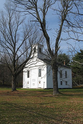
The Moore's Corner Historic District of Leverett, Massachusetts, encompasses the historic rural mill village of Moore's Corner. Centered on the intersection of North Leverett Road with Dudleyville Road, Church Hill Road, and Rattlesnake Gutter Road, it includes 15 houses and several other buildings, mainly from the village's mid-19th century peak as a modest rural village center. The district was listed on the National Register of Historic Places in 2014.

The Plainfield Village Historic District encompasses a significant portion of the village of Plainfield, Vermont. Located in northernmost Plainfield on United States Route 2, the village grew in the 19th century as a mill town and service community for the surround agricultural areas, and has a well-preserved collection of Greek Revival and Italianate architecture. It was listed on the National Register of Historic Places in 1983.

The Dunstable Center Historic District encompasses the town center of Dunstable, Massachusetts. Centered at the junction Main, High, and Pleasant Streets, this area has served as the town center since 1791, when its church was moved here. The district, now home to a broad array of residential and civic architecture, was listed on the National Register of Historic Places in 2002.


