
Taney County is a county located in the southwestern portion of the U.S. state of Missouri. As of the 2010 census, the population was 51,675. Its county seat is Forsyth. It is included in the Branson, Missouri, Micropolitan Statistical Area.

Bradleyville is an unincorporated community in northeastern Taney County, Missouri, United States. It is located at the intersection of Route 76 and Route 125 above the west bank of Beaver Creek. Bradleyville is part of the Branson, Missouri Micropolitan Statistical Area.
Almartha is an unincorporated community in northern Ozark County, Missouri, United States. It is located approximately thirteen miles north of Gainesville and four miles southeast of Wasola on Route 95. The village is located in a valley on a tributary of Spring Creek. Several homes are located there. The old mill and current fish hatchery of Rockbridge lies downstream on Spring Creek, about six miles to the east.
Isabella is an unincorporated community in Ozark County, Missouri, United States. It is located approximately thirteen miles west of Gainesville and two miles east of Theodosia and Bull Shoals Lake along U.S. Highway 160. Isabella has a post office with the ZIP code 65676.

Thornfield is an unincorporated community in Ozark County, Missouri, United States. It is located 15 miles (24 km) northwest of Gainesville, on Route 95 at the Little North Fork of the White River on the edge of the Mark Twain National Forest between Wasola to the northeast and Longrun to the southwest. Hammond, the site of the historic Hammond Mill, lies on the Little North Fork 2.5 miles (4.0 km) southeast of Thornfield. Thornfield has a post office with ZIP code 65762.
Tecumseh is an unincorporated community in eastern Ozark County in southern Missouri, United States. It is located on the North Fork River at the north end of Norfork Lake, approximately ten miles east of Gainesville and 32 miles west of West Plains on U.S. Highway 160. Tecumseh has a post office with ZIP code 65760.
Hardenville is an unincorporated community in eastern Ozark County in southern Missouri, United States. It is located on U.S. Highway 160, approximately five miles east of Gainesville and five miles west of Tecumseh, which is at the north end of Norfork Lake. The community is located on an Ozark ridge at an elevation of 963 feet (294 m).

Brixey is an unincorporated community in northern Ozark County, Missouri, United States. It is located 1.6 miles (2.6 km) south of Route 95 on Route N or approximately 10 miles (16 km) north of Gainesville.

McClurg is an unincorporated community in extreme northeastern Taney County, Missouri, United States. It is located on Missouri Supplemental Route W, approximately three miles east of Brownbranch or twenty miles (32 km) northeast of Forsyth. McClurg is part of the Branson, Missouri Micropolitan Statistical Area.
Powersite is an unincorporated community in Taney County, Missouri, United States. It is located across Lake Taneycomo from Forsyth on the southeast end of Powersite Dam. The community is part of the Branson, Missouri Micropolitan Statistical Area.

Walnut Shade is an unincorporated community in Taney County, Missouri, United States. It is located approximately six miles northwest of Forsyth on U.S. Route 160. The town sits at the confluence of Bull and Bear Creeks. Walnut Shade is part of the Branson, Missouri Micropolitan Statistical Area.
Kirbyville is a village in Taney County, Missouri, United States. The population was 207 at the 2010 census. It is part of the Branson, Missouri Micropolitan Statistical Area.
Smallett is an unincorporated community in southern Douglas County, Missouri, United States. It is located approximately nine miles south of Ava and is located on Missouri Supplemental Route A. It previously had its own post office from 1888-1967 with ZIP code 65750, but mail is now served by the post office in Ava. Some say Smallett was named for its first postmaster, James Small, while others believe the name honors another early settler.
Cedar Creek or Cedarcreek is an unincorporated community in Taney County, Missouri, United States. It is located approximately fifteen miles southeast of Branson at the intersection of Missouri Supplemental Routes M and KK. The stream Cedar Creek lies about three miles north on route M. The community is part of the Branson, Missouri Micropolitan Statistical Area.

Hilda is an unincorporated community in Taney County, Missouri, United States. It is located on U.S. Route 160 two miles east of the Kissee Mills recreation area on the Beaver Creek arm of Bull Shoals Lake and approximately fifteen miles east of Branson. The Hilda Lookout Tower in approximately one mile south on Lime Kiln Mountain. Hilda is part of the Branson Micropolitan Statistical Area.

Knob Lick is an unincorporated community in southern Saint Francois County, Missouri, United States. It is located on Missouri Route DD, just east of U.S. Route 67, approximately eight miles south of Farmington.
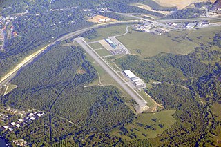
M. Graham Clark Downtown Airport is a county-owned, public-use airport in Taney County, Missouri, United States. It is located one nautical mile (2 km) south of the central business district of Branson, Missouri, one nautical mile (2 km) northeast of Point Lookout, Missouri, and a few yards west of the old downtown area of Hollister, Missouri. It was formerly known as M. Graham Clark Field – Taney County Airport.
Eastview is an extinct town in northeastern Taney County, in the Ozarks of southwest Missouri. The location is along a ridge occupied by Farm Road 147 which is a portion of the scenic Glade Top Trail within the Mark Twain National Forest.
Garber is an unincorporated community in western Taney County in the Ozarks of southern Missouri. Garber is located along the Missouri Pacific Railroad line and Roark Creek, approximately four miles northwest of Branson.
Nance is an extinct town in eastern Taney County, in the Ozarks of southwest Missouri. The GNIS classifies it as a populated place. The townsite sits above the east bank of the west fork of Big Creek about one mile north of U.S. Route 160 and about 1.7 miles west of the Taney - Ozark county line. The site is at an elevation of 876 feet.

